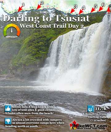
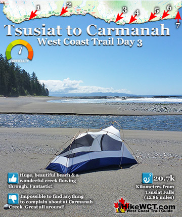
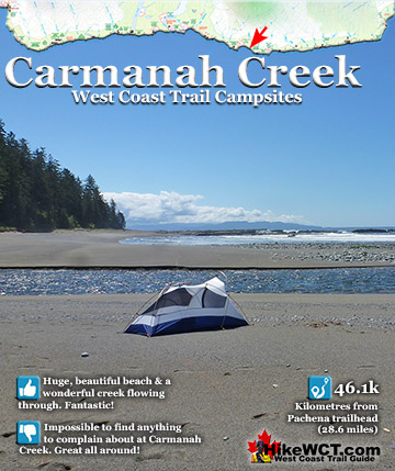
![]() After camping at Tsusiat Falls and Carmanah Creek, you start to fall in love with every new campsite. Tsusiat Falls with its sweeping ocean views with the occasional passing whales to its crashing falls just steps from your tent. At Carmanah Creek you have a terrific beach that goes on and on. On a sunny day it is a stunning West Coast Trail paradise very hard to leave.
After camping at Tsusiat Falls and Carmanah Creek, you start to fall in love with every new campsite. Tsusiat Falls with its sweeping ocean views with the occasional passing whales to its crashing falls just steps from your tent. At Carmanah Creek you have a terrific beach that goes on and on. On a sunny day it is a stunning West Coast Trail paradise very hard to leave.
 Carmanah Beach is paradise on a sunny day!
- Beautiful, easy beach hiking for much of the day
- Cable car crossing at Carmanah & Walbran
- Bonilla Falls is an easily missed, amazing place
- Bonilla Creek has amazing sunrises & sunsets
- Carmanah, Bonilla & Walbran are skipped by most!
- Shipwreck debris at Bonilla Point from the Puritan
- Walbran campsite is comparatively deserted
- Walbran Creek & Beach are very nice
 If the beach was white sand it would be perfect!
Hike the West Coast Trail
![]() Prologue
Prologue ![]() 1: The West Coast Trail
1: The West Coast Trail ![]() 2: When to Hike & Fees
2: When to Hike & Fees ![]() 3: Trailheads
3: Trailheads ![]() 4: Getting There
4: Getting There ![]() 5: Considerations
5: Considerations ![]() 6: Campsites
6: Campsites ![]() 7: Shipwrecks
7: Shipwrecks ![]() 8: Routes
8: Routes ![]() Day 1 Pachena to Darling
Day 1 Pachena to Darling ![]() Day 2 Darling to Tsusiat
Day 2 Darling to Tsusiat ![]() Day 3 Tsusiat to Carmanah
Day 3 Tsusiat to Carmanah ![]() Day 4 Carmanah to Walbran
Day 4 Carmanah to Walbran ![]() Day 5 Walbran to Cullite
Day 5 Walbran to Cullite ![]() Day 6 Cullite to Camper
Day 6 Cullite to Camper ![]() Day 7 Camper to Thrasher
Day 7 Camper to Thrasher ![]() Michigan Creek at 12k
Michigan Creek at 12k ![]() Darling River at 14k
Darling River at 14k ![]() Orange Juice Creek at 15k
Orange Juice Creek at 15k ![]() Tsocowis Creek at 16.5k
Tsocowis Creek at 16.5k ![]() Klanawa River at 23k
Klanawa River at 23k ![]() Tsusiat Falls at 25k
Tsusiat Falls at 25k ![]() Cribs Creek at 42k
Cribs Creek at 42k ![]() Carmanah Creek at 46k
Carmanah Creek at 46k ![]() Bonilla Creek at 48k
Bonilla Creek at 48k ![]() Walbran Creek at 53k
Walbran Creek at 53k ![]() Cullite Cove at 58k
Cullite Cove at 58k ![]() Camper Bay at 62k
Camper Bay at 62k ![]() Thrasher Cove at 70k
Thrasher Cove at 70k
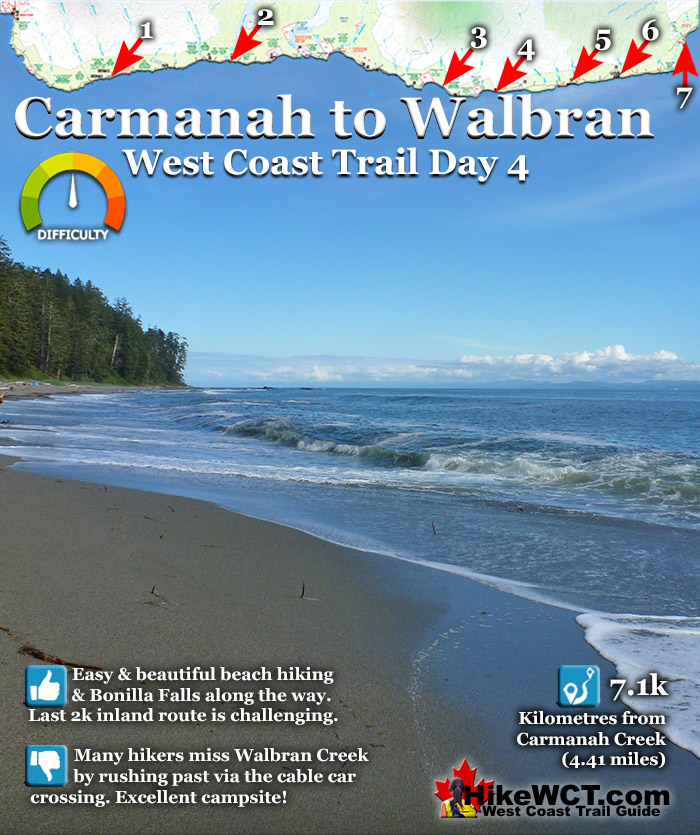
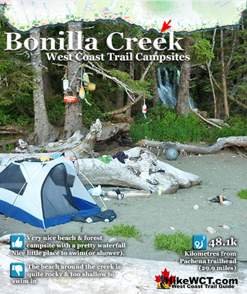
As you continue hiking south, you have some good news and bad news. The bad news is the West Coast Trail starts getting harder, a lot harder. You get a nice 6 kilometres of beautiful beach hiking, then plunge back into the forest. The ladders become very frequent and increasingly long. If you are hiking early in the season, you will bog down in knee deep sections of mud and find your pace reduced to about 1 kilometre an hour! The good news is that there is a string of excellent campsites quite close together on the horizon. Bonilla Creek campsite is just two kilometres past Carmanah Creek and an excellent campsite in its own right. It is easy to hike past Bonilla Creek and not give it a second glance. The creek is a bit shallow, rocky and reddish coloured from the tannins leached from the forest. Runoff water from tree roots and decaying vegetation colours most creeks and rivers along the West Coast Trail a beer or tea colour. If you follow Bonilla Creek to Bonilla Falls you will find a cute little world that feels hidden. The campsite that is revealed in the forest next to the falls stretches for about 100 metres and is packed with curiosities. From wooden carvings and art crafted from flotsam, to extraordinary hammock that must have been crafted from an old fishing net. Added to that you have a very pretty waterfall with a small pool that begs you to jump into. If you were to camp here, you get some sensational sunsets with an array of deep blue to vibrant orange and the sun disappears behind the horizon.
If you do continue past Bonilla Creek you have some easy and very nice beach hiking followed by a kilometre or two of tough, wilderness hiking before you reach the very long cable car crossing across Walbran Creek. Walbran Creek is wide and shallow, but still plenty deep for a great swim. As with Bonilla Creek, most hikers don't give the Walbran Campsite a second glance. In fact few West Coast Trail hikers give it a glance at all, owing to a tough detour from the main trail. This small detour keeps Walbran relatively deserted. And what a wonderful place to have to yourself! Walbran Creek feels like a secret hideaway and even though it is just 7 kilometres from Carmanah Creek, it is highly recommended to spend the night.

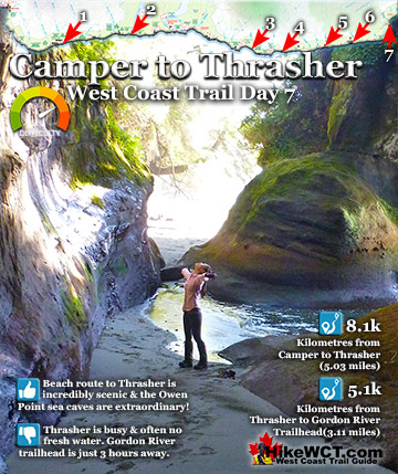
After Walbran Creek, then next campsite is Cullite Cove, just 5 kilometres away. Once again, you should plan a night at this excellent campsite. The 5 kilometres between Walbran Creek and Cullite Cove are some of the most challenging and exhilarating hours you will encounter on the West Coast Trail. Logan Creek at 56km is the insane collection of ladders down to the long and narrow bridge crossing, followed by the ridiculously elaborate set of ladders up the other side. You will have seen pictures of this crossing before setting out on the West Coast Trail, but they wouldn't have prepared you for the stunning length of both the bridge crossing and the network of tall ladders on either side. It is on this tough section of trail you should remind yourself about the warning at the orientation before you set off. They urge you to take your time and not push yourself to hike too far, too fast. The good news is that you don't have to. Excellent and ever changing campsites are many, and kilometres between them are few!
Leaving Carmanah Creek: West Coast Trail Day 4
Carmanah Creek is a beautiful spot on the West Coast Trail and even leaving it is amazing. You start off by climbing the tall ladder up to the cable car platform. There are several cable car crossings along the West Coast Trail and they are all fun. On most, you tend to pause halfway across and marvel at the beautiful view. The Carmanah Creek view is one of the best. The creek cuts through the sand beach to the ocean. If you are lucky enough to cross in the evening you get a fantastic sunset view as the sun descends down behind the Pacific.

Bonilla Point at 48km on the West Coast Trail
The two kilometres between Camanah Creek and Bonilla Point is along a continuously nice, sandy beach. Low tide exposes the rocky reef that is quite messy and ugly compared to the tidy and smooth sandy beach. Bonilla Point has this funny little island in the midst of the barren reef. The island is covered in what must be the hardiest vegetation on the planet as well as two beautifully resilient trees. Both trees are angled in various directions along their trunks as they have endured decades of winter storm battering.

Refuge Rock at Bonilla Point
The closer you get to this little island, appropriately named Refuge Rock, the more impressive the trees become. One is extending out the side of the island, which from this angle appears like a giant boulder. The tree even appears to have roots dangling down from it searching for the ground.

Beautiful Bonilla Falls
Just a couple hundred metres past the resilient island you see a small, tannin coloured stream cutting through the beach to the ocean. Following it to the edge of the forest you see Bonilla Falls pouring over a short cliff out of the rainforest.

Bonilla Falls is located in a strikingly beautiful place. Standing next to the falls you are exactly where the rainforest and beach meet. Glance to the right and you see nothing but beach extending to the ocean. Glance to the left and you find yourself inside an amazingly lush rainforest that you immediately realize is the often missed and very under appreciated Bonilla Falls campsite.

Bonilla Creek Campsite at 48km
![]() The Bonilla Creek campsite is easy to miss, as it looks very unassuming from the beach as most hikers pass by. Bonilla Falls, however is nestled against a small cliff at the edge of a suddenly deep forest. And the forest hides a nice little world, somewhat sheltered from the elements. An outhouse sits up at the far end, and several tent clearings stretch to the beach where you find a wonderful hammock cobbled together over the years out of old fishing nets and ropes. A bit surreal in such a remote feeling place, but it is so elaborate that it makes you look around for permanent residents! You won't find any permanent human residents, however, you will encounter some wildlife as there always seems to be a bear or two walking the shoreline between Bonilla Point and Carmanah Creek in the early morning hours.
The Bonilla Creek campsite is easy to miss, as it looks very unassuming from the beach as most hikers pass by. Bonilla Falls, however is nestled against a small cliff at the edge of a suddenly deep forest. And the forest hides a nice little world, somewhat sheltered from the elements. An outhouse sits up at the far end, and several tent clearings stretch to the beach where you find a wonderful hammock cobbled together over the years out of old fishing nets and ropes. A bit surreal in such a remote feeling place, but it is so elaborate that it makes you look around for permanent residents! You won't find any permanent human residents, however, you will encounter some wildlife as there always seems to be a bear or two walking the shoreline between Bonilla Point and Carmanah Creek in the early morning hours.

Wild and Extraordinary Bonilla Creek Campsite
The campsite at Bonilla Creek has some beautiful characteristics. First the cute, Bonilla Falls have a perfect little pool to swim in and wash off the days hiking grime. Second, the campsite is quite good with lots of varied places to put up a tent as well as some driftwood structures out on the beach. Third, the sunsets are sensational here. Bright orange, with the narrow islands in the distance topped by improbable looking trees. Added to that, you have a relatively quiet campsite compared to other West Coast Trail campsites.

On a sunny day the forest lights up neon green and sunbeams cut through the forest and reflect in so many directions you can quite tell what direction they are coming from. The campsite is a striking combination of rainforest and beach. Most of the time you are walking on sand, yet all around you are trees and huge, fallen trees covered in bright green moss. Standing in the trees you feel strangely protected from the elements and almost like you are indoors. A few steps away and you emerge from the jungle and into the wide open and beach stretching to the horizon.

Variety of Tent Locations
There are quite a few clearings for your tent, both in the forest and out along the edge of the beach. There are so many perfect tent spots that you can't quite believe it. What a fantastic place.

Beautiful Sunset at Bonilla Falls
If you decide to spend the night at Bonilla Falls, you will be in for a spectacular sunset over Refuge Rock in the middle of the reef.

Bonilla Point and Refuge Rock in 1975
Decades of crashing waves have cut away and smoothed Refuge Rock. This is an old picture of Bonilla Point and Refuge Rock from 1975.

As the sun sinks into the Pacific the sky goes from blue to yellow, to orange and finally red with Refuge Rock a wonderful silhouette.

Leaving Bonilla and the Puritan Shipwreck at 48.5km
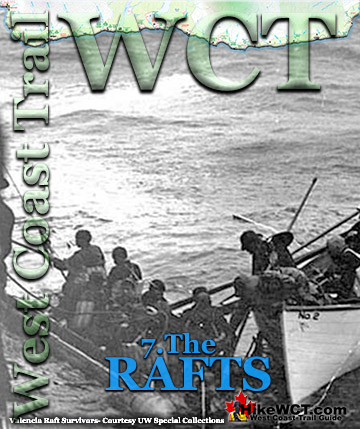
![]() The Puritan was a 4 masted schooner of 614 tons sailing inbound from San Francisco in ballast. She was heading for Port Gamble in Washington to pick up a load of lumber when the crew failed to account for the strong current in the Juan de Fuca Strait. Owing to the thick fog and heavy seas, the Puritan stumbled blindly into the rocks of Bonilla Point. The crew of 10 made the same mistake that hundreds of crews before them made. They didn't reckon their course with the notorious, strong current of the Juan de Fuca Strait. The current pushed them far northwest of their perceived position. Unable to see due to the thick fog, stormy weather and darkness of night the Puritan was pushed into the rocky Bonilla Point. The record shows that she was wrecked at 5am on November 13, 1896. The crew decided to wait for daybreak to figure out their escape. When the morning finally came, a lone Indian found them and battling the surf, managed to run a rope from the ship to the shore. The crew used the life-line to escape the crumbling ship. The Puritan, continuously bashed by the sea until on the following day she was laying her masts in the surf, and quickly began breaking up. The crew made their way to the Carmanah Point Lighthouse and later ferried to Victoria. For his heroic efforts, the Indian was reportedly rewarded. Today hiking the West Coast Trail, you will find some of the ship's remains on the outer reef.
The Puritan was a 4 masted schooner of 614 tons sailing inbound from San Francisco in ballast. She was heading for Port Gamble in Washington to pick up a load of lumber when the crew failed to account for the strong current in the Juan de Fuca Strait. Owing to the thick fog and heavy seas, the Puritan stumbled blindly into the rocks of Bonilla Point. The crew of 10 made the same mistake that hundreds of crews before them made. They didn't reckon their course with the notorious, strong current of the Juan de Fuca Strait. The current pushed them far northwest of their perceived position. Unable to see due to the thick fog, stormy weather and darkness of night the Puritan was pushed into the rocky Bonilla Point. The record shows that she was wrecked at 5am on November 13, 1896. The crew decided to wait for daybreak to figure out their escape. When the morning finally came, a lone Indian found them and battling the surf, managed to run a rope from the ship to the shore. The crew used the life-line to escape the crumbling ship. The Puritan, continuously bashed by the sea until on the following day she was laying her masts in the surf, and quickly began breaking up. The crew made their way to the Carmanah Point Lighthouse and later ferried to Victoria. For his heroic efforts, the Indian was reportedly rewarded. Today hiking the West Coast Trail, you will find some of the ship's remains on the outer reef.

The Wempe Brothers Shipwreck at 49.4km
![]() The Wempe Brothers was a 4 masted schooner just 70 tons heavier than the Puritan, that wrecked here a century ago. The Wempe Brothers was sailing in from San Pedro, California in ballast. She was heading for Puget Sound to pick up lumber when she was claimed by the Graveyard of the Pacific. The crew of 10 experienced very stormy weather as she neared the Cape Flattery lighthouse and entrance to Juan de Fuca Strait. Light winds and thick fog carried them towards the strait, however the fast current pulled them irresistibly north towards the coast of Vancouver Island. The Wempe Brothers was carried so close to Carmanah Point Lighthouse that the lighthouse lights were reported to be reflected on the ships sails and hull. The crew had no idea they were so far out of their intended position and the sudden appearance of a lighthouse must have been terrifying. The wind was dead calm so sailing to safety was not an option. The crew managed to drop two anchors in a desperate effort to halt the ship before colliding with the shore. It was too late, however, as the Wempe Brothers was carried onto the beach at 5am on October 28th, 1903. This is a picture of the beach where Wempe Brothers wrecked.
The Wempe Brothers was a 4 masted schooner just 70 tons heavier than the Puritan, that wrecked here a century ago. The Wempe Brothers was sailing in from San Pedro, California in ballast. She was heading for Puget Sound to pick up lumber when she was claimed by the Graveyard of the Pacific. The crew of 10 experienced very stormy weather as she neared the Cape Flattery lighthouse and entrance to Juan de Fuca Strait. Light winds and thick fog carried them towards the strait, however the fast current pulled them irresistibly north towards the coast of Vancouver Island. The Wempe Brothers was carried so close to Carmanah Point Lighthouse that the lighthouse lights were reported to be reflected on the ships sails and hull. The crew had no idea they were so far out of their intended position and the sudden appearance of a lighthouse must have been terrifying. The wind was dead calm so sailing to safety was not an option. The crew managed to drop two anchors in a desperate effort to halt the ship before colliding with the shore. It was too late, however, as the Wempe Brothers was carried onto the beach at 5am on October 28th, 1903. This is a picture of the beach where Wempe Brothers wrecked.

Beautiful Beach at 50km


Skull Near 50km on the West Coast Trail


Upside Down Beach Tree Near 50km

Vancouver Point View from Beach Near 50km

Insane West Coast Trail Ladders Near Vancouver Point
Just past the 51km mark of the West Coast Trail the easy beach walking ends and this tremendously huge set of ladders takes you high up into the rainforest. Through the trees you can see Vancouver Point stretch out from the rocky shore. There is also a beach route that you can take which is much easier than the crazy forest route. The beach route involves wading or possibly swimming across Walbran Creek as there is no bridge. The forest route leads to the cable car crossing high above Walbran Creek.

The view from the top of the ladders is Vancouver Point.

Brutal Forest Trail to Walbran Creek
The forest trail that runs from about 51km to Walbran Creek at 53km is brutal with deadfall across the trail, big muddy section with missing boardwalk and a ridiculously huge tree wall at 52km.


Walbran Creek Campsite at 53km
![]() Walbran Creek at 53k is home to possibly the best, and most unappreciated campsites on the West Coast Trail. It encapsulates so much that makes the West Coast Trail truly wonderful. The expansive beach which seems purpose built for enjoyability is flanked by scenic cliffs and creek on one side, the pacific ocean on the other, and backed by the emerald coloured Walbran Creek that flows through the jungle valley spanned by a cable car crossing! Of the list of pro's and con's for Walbran Creek, the list is hopelessly lopsided to the pro's. Walbran Creek campsite is reached in the middle of the most challenging, invigorating, stunning, bewildering and breathtaking section of the West Coast Trail. The ladders you encounter heading either direction from the campsite are astounding in size. One after another you ascend and descend the most improbably long and slippery, wooden ladders that always feel solid and safe, despite their obvious age and weathering.
Walbran Creek at 53k is home to possibly the best, and most unappreciated campsites on the West Coast Trail. It encapsulates so much that makes the West Coast Trail truly wonderful. The expansive beach which seems purpose built for enjoyability is flanked by scenic cliffs and creek on one side, the pacific ocean on the other, and backed by the emerald coloured Walbran Creek that flows through the jungle valley spanned by a cable car crossing! Of the list of pro's and con's for Walbran Creek, the list is hopelessly lopsided to the pro's. Walbran Creek campsite is reached in the middle of the most challenging, invigorating, stunning, bewildering and breathtaking section of the West Coast Trail. The ladders you encounter heading either direction from the campsite are astounding in size. One after another you ascend and descend the most improbably long and slippery, wooden ladders that always feel solid and safe, despite their obvious age and weathering.

Walbran Cable Car Crossing at 53km
Even the cable car crossing is exhilarating. It is a very long one and this one in particular invites you to stop midway and take in the stunning view in either direction. Upstream the view is an emerald coloured creek(though it looks more like a river in size), flanked by a beautifully tangled rainforest jungle. The view in the other direction is of the Pacific Ocean framed by trees on either side. Though this image is pretty, it doesn't reveal the true beauty of the campsite that spills out along the beach, just out of view. For most, this cable car glimpse is the closest they get to the Walbran Creek campsite. Such a shame as they are passing a little piece of West Coast Trail paradise.


Beautiful Walbran Campsite
If you do venture down the short side trail to the campsite, almost entirely on the beach you will be instantly surprised by the beach of weather rounded rocks and maze of driftwood logs. Though a beautiful, sandy beach may be your ideal, a pebble beach is a close second. Clean and tidy, you don't get a sleeping bag full of sand. The driftwood logs are semi permanent and have been adjusted over time to create divided clearings. Little, marvelously segregated, sandy patches ideal for tents. You could be 10 metres from your neighbour and the wall of driftwood logs blocks the sight and sound you might get from others. So you have privacy, which you may not need as Walbran Creek is one of the less visited campsites on the West Coast Trail and where you may find dozens of tents at Tsusiat Falls or Camper Bay. At Walbran Creek you may encounter nobody!


Added to the serenity, you get the ever-present ocean view in front of you. The United States is easily visibly across Juan de Fuca Strait, and you can imagine the ships just a century ago reaching Cape Flattery, the point of land in the US, across from you extending into the Pacific. Often sailing up from San Francisco in calm weather, only to reach Cape Flattery and get hit by a winter storm that batters your ship and blinds you in fog. You then creep into what you think is Juan de Fuca Strait towards Puget Sound, Victoria or Vancouver, when in fact the strong current has brought you into the teeth of the Graveyard of the Pacific. Hundreds of ships were driven into the rocky flank of Vancouver Island and became victims of this treacherous corner of the world. This sinister past of course necessitated the creation of the West Coast Trail which would go on to save hundreds of shipwreck survivors and in 1970 become an officially defined national park.

Walbran Creek is Great for Swimming
At the end of a long day hiking the West Coast Trail, having a nice body of water to wash in.. or better yet jump into is always desired. Walbran Creek flows just steps from your tent, crystal clear, and very inviting. You can swim across the the opposite shore where you will find some small sea caves and a narrow, rocky shore. At the mouth of Walbran Creek, where it meets the ocean you will find a shallow area that is the beach route on the West Coast Trail heading north. It does involve crossing water deeper than most feel comfortable with, so you don't often see people use this route. Also, it avoids the very enjoyable cable car crossing. If you are brave and keen to plunge into the wild Pacific Ocean, you are just steps from that too. You walk straight into the ocean and meet some big breakers. Feel what all the shipwreck survivors felt, scrambling to safety after emerging from the Graveyard of the Pacific. You can plunge into the ocean, then plunge into Walbran Creek moments later as they are separated by a narrow section of beach.


West Coast Trail Day 5: Walbran to Cullite
The West Coast Trail by Day

West Coast Trail Campsites
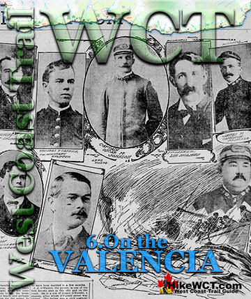
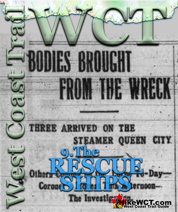
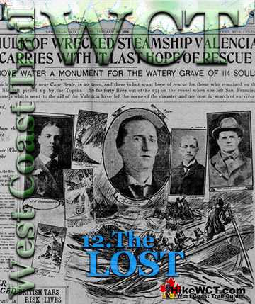
The Valencia Disaster
Explore BC Hiking Destinations!
The West Coast Trail
Victoria Hiking Trails
Clayoquot Hiking Trails
Whistler Hiking Trails

Squamish Hiking Trails

Vancouver Hiking Trails