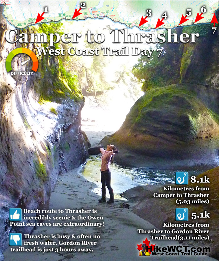
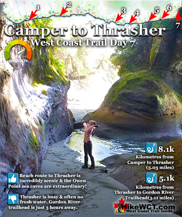
![]() Day 7 on the West Coast Trail from Camper Bay to Thrasher Cove or further along to the Gordon River trailhead gives you two route options. After three kilometres of very challenging rainforest hiking from Camper Bay, you come to a beach access route that branches off the main trail. From this point near 65km you can hike along the coast all the way to Thrasher Cove, or hike this section completely inland.
Day 7 on the West Coast Trail from Camper Bay to Thrasher Cove or further along to the Gordon River trailhead gives you two route options. After three kilometres of very challenging rainforest hiking from Camper Bay, you come to a beach access route that branches off the main trail. From this point near 65km you can hike along the coast all the way to Thrasher Cove, or hike this section completely inland.
 Cable car at Camper to start your day!
- Amazing beach route starts at 65k
- Rock shelf full of tidal pool sea life
- Rock shelf is slippery, yet easy hiking
- Extraordinary ocean eroded cliff faces
- Flowers at 150 Yard Creek are stunning
- Off the radar campsite at 150 Yard Creek
- Owen Point sea caves are beautiful
 Can only hike beach route at mid to low tide
- Fresh water sources are hard to find
Hike the West Coast Trail
![]() Prologue
Prologue ![]() 1: The West Coast Trail
1: The West Coast Trail ![]() 2: When to Hike & Fees
2: When to Hike & Fees ![]() 3: Trailheads
3: Trailheads ![]() 4: Getting There
4: Getting There ![]() 5: Considerations
5: Considerations ![]() 6: Campsites
6: Campsites ![]() 7: Shipwrecks
7: Shipwrecks ![]() 8: Routes
8: Routes ![]() Day 1 Pachena to Darling
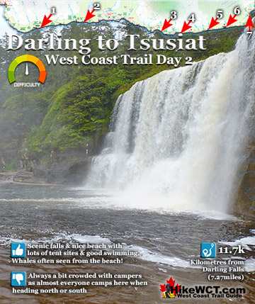
Day 1 Pachena to Darling ![]() Day 2 Darling to Tsusiat
Day 2 Darling to Tsusiat ![]() Day 3 Tsusiat to Carmanah
Day 3 Tsusiat to Carmanah ![]() Day 4 Carmanah to Walbran
Day 4 Carmanah to Walbran ![]() Day 5 Walbran to Cullite
Day 5 Walbran to Cullite ![]() Day 6 Cullite to Camper
Day 6 Cullite to Camper ![]() Day 7 Camper to Thrasher
Day 7 Camper to Thrasher ![]() Michigan Creek at 12k
Michigan Creek at 12k ![]() Darling River at 14k
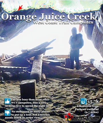
Darling River at 14k ![]() Orange Juice Creek at 15k
Orange Juice Creek at 15k ![]() Tsocowis Creek at 16.5k
Tsocowis Creek at 16.5k ![]() Klanawa River at 23k
Klanawa River at 23k ![]() Tsusiat Falls at 25k
Tsusiat Falls at 25k ![]() Cribs Creek at 42k
Cribs Creek at 42k ![]() Carmanah Creek at 46k
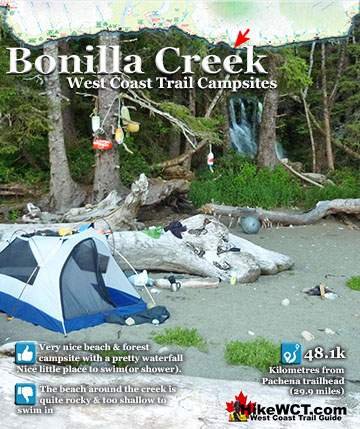
Carmanah Creek at 46k ![]() Bonilla Creek at 48k
Bonilla Creek at 48k ![]() Walbran Creek at 53k
Walbran Creek at 53k ![]() Cullite Cove at 58k
Cullite Cove at 58k ![]() Camper Bay at 62k
Camper Bay at 62k ![]() Thrasher Cove at 70k
Thrasher Cove at 70k
The difference between these two routes is considerable and the beach route is better in almost all respects. The inland route is challenging, much like the previous few kilometres, but not quite as tough. You don't see much of interest and it is a bit of an endurance test all the way to the Thrasher Cove trail down to the beach at 70k. The beach route, however, is one dramatically changing coastal shelf after another. This rocky shelf coastal route is a sharp contrast to the sandy beaches of previous days of the West Coast Trail. They are quite beautiful and you find yourself hiking across one massive and very flat, rock surface and suddenly it ends at a vertical drop to the ocean of a dozen metres. After taking in the breathtaking view, you realize you have to hike toward the treeline and skirt the bay to get to the other side. This happens a lot, and each one is a marvelous game of which way should we go? One wrong turn and you come to a dead end chasm only a couple metres wide, but wide enough to circle back around to a route that doesn't offer the chance of falling several metres into the swirling torrent of water below! Many of the the sections along the ocean have tidal pools full of sea life. These sections have the hazard of slippery sections that catch you off guard and send you crashing backwards with your pack breaking your fall if you are lucky.
Constantly Interesting Erosion Carved Coast
Some sections are pretty slimy and not terribly scenic, but much of the route is a dramatically changing glimpses of ocean views and bizarre erosion-formed curiosities. The abrupt rock cliffs that separate most of the route from the forest a dozen metres above is a geological work of art. Relentless waves have carved the rock into a slope upwards then curves into an overhang with the rainforest spilling over. Some massive trees in the forest above are being cut away from the forest and are ominously leaning toward the ocean.

Stunning West Coast Trail Rock Shelf Road
Sections of the flat rocky coastline are mysteriously banded. You you have a raised section, almost like a road, running parallel to the coast. Past it you have a dozen metres of flat rock about a metre lower, then another raised band further out by the ocean waves. These curious ridges entice you to follow them further and further out, but almost always leave you splashing through knee deep, ocean water sections to regain the route. When you received your tide table instructions on your West Coast Trail orientation session, this section of trail was a big reason being aware of tides is so important. You have to hike this beautiful, coastal route when the tides are low. The problem is that there is quite a lot to see on the way and you have to give yourself plenty of time and plenty of leeway to get through safely.

The Last Two Campsites on the West Coast Trail
![]() The two campsites at this end of the West Coast Trail are not the best. Camper Bay is always very busy and Thrasher Cove is less busy, but much smaller, so can accommodate far fewer campers comfortably. Added to that Thrasher Cove is often lacking fresh water as the streams often run dry after periods of dry weather, especially mid to late summer. If you are adventurous and inclined to camp away from the crowds you will a nice place for your tent near 150 Yard Creek, just past 66k on the West Coast Trail map. You likely will find no trace of previous campers, however you will find a very nice little sandy beach, perfect to set up camp. 150 Yard Creek is easy to miss if you are not looking for it. The water often flows over the rock shelf to the ocean as a paper thin sheet of water. One tell-tale sign you have found 150 Yard Creek is the stunning forest of yellow flowers that cover the rock face surrounding the creek. The flowers catch your attention so much, that you barely notice the thin layer of water that is 150 Yard Creek.
The two campsites at this end of the West Coast Trail are not the best. Camper Bay is always very busy and Thrasher Cove is less busy, but much smaller, so can accommodate far fewer campers comfortably. Added to that Thrasher Cove is often lacking fresh water as the streams often run dry after periods of dry weather, especially mid to late summer. If you are adventurous and inclined to camp away from the crowds you will a nice place for your tent near 150 Yard Creek, just past 66k on the West Coast Trail map. You likely will find no trace of previous campers, however you will find a very nice little sandy beach, perfect to set up camp. 150 Yard Creek is easy to miss if you are not looking for it. The water often flows over the rock shelf to the ocean as a paper thin sheet of water. One tell-tale sign you have found 150 Yard Creek is the stunning forest of yellow flowers that cover the rock face surrounding the creek. The flowers catch your attention so much, that you barely notice the thin layer of water that is 150 Yard Creek.

Best Sights on Day 7 Camper to Thrasher
![]() 150 Yard Creek is just one of the many memorably sights on this coastal route, but the most stunning highlight is about to come. The sea caves at Owen Point are a wonderfully eroded and often vividly coloured little world nestled along the edge of the point. If you are lucky and explore them on a sunny day, you will find the sides of the caves glowing bright green and orange. What an amazing little place carved by centuries of ocean waves. On a beautiful day on the West Coast Trail, this spot might find its way to the top of your list of memorable moments from the trail. The Owen Point sea caves are reason enough to hike the coastal route over the inland route. The inland route is lacking in comparable highlights and Owen Point is just one of many spots that are amazing on the coast route. As long as you judge your tide tables correctly, you will have a safe and very enjoyable day hiking the endlessly surprising West Coast Trail.
150 Yard Creek is just one of the many memorably sights on this coastal route, but the most stunning highlight is about to come. The sea caves at Owen Point are a wonderfully eroded and often vividly coloured little world nestled along the edge of the point. If you are lucky and explore them on a sunny day, you will find the sides of the caves glowing bright green and orange. What an amazing little place carved by centuries of ocean waves. On a beautiful day on the West Coast Trail, this spot might find its way to the top of your list of memorable moments from the trail. The Owen Point sea caves are reason enough to hike the coastal route over the inland route. The inland route is lacking in comparable highlights and Owen Point is just one of many spots that are amazing on the coast route. As long as you judge your tide tables correctly, you will have a safe and very enjoyable day hiking the endlessly surprising West Coast Trail.

Day 7: Camper Bay to Thrasher Cove on the West Coast Trail
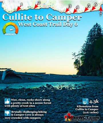
![]() The trail from Camper Bay in both directions is pretty brutal with ladders and erratic terrain, so you and your fellow hikers with be exhausted. Cullite Cove is just 4 kilometres down the West Coast Trail at kilometre 58. One of the nicest campsites you will find, it has everything, a lovely wooded area with clearings for tents and campfires. Stunning views all around. A terrific, rocky beach, beautifully hemmed in by beautiful cliffs on either side. Cullite Creek pours into the cove, making for a stunning, albeit freezing swim into the surf. The campsite here is often very quiet as everybody seems to camp at Camper Bay just 4 kilometres away and doesn't even drop down the short detour off the main trail to Cullite Cove.
The trail from Camper Bay in both directions is pretty brutal with ladders and erratic terrain, so you and your fellow hikers with be exhausted. Cullite Cove is just 4 kilometres down the West Coast Trail at kilometre 58. One of the nicest campsites you will find, it has everything, a lovely wooded area with clearings for tents and campfires. Stunning views all around. A terrific, rocky beach, beautifully hemmed in by beautiful cliffs on either side. Cullite Creek pours into the cove, making for a stunning, albeit freezing swim into the surf. The campsite here is often very quiet as everybody seems to camp at Camper Bay just 4 kilometres away and doesn't even drop down the short detour off the main trail to Cullite Cove.

The Camper Creek Cable Car Crossing
![]() Day 7 of the West Coast Trail starts off with a fun cable car crossing across Camper Creek. This is the last cable car crossing and takes you to the very challenging rainforest trail on your way to Thrasher Cove and beyond that, the West Coast Trail trailhead at Gordon River in Port Renfrew. Cable cars have been used on the West Coast Trail long before it was called the West Coast Trail. They are much easier, cheaper and faster to build that a bridge and pretty easy to maintain. If a cable car gets damaged from a storm over the winter it is much easier to repair than a damaged bridge. Compared to a bridge, cable cars are way more fun and it is hard not to feel a kid like excitement when you arrive at one on the West Coast Trail. There are five amazing cable car crossings on the West Coast Trail, Camper Creek, Cullite Creek, Walbran Creek, Carmanah Creek and Klanawa River. This one a Camper Creek is the shortest one, but still an amazing way to start your day hiking.
Day 7 of the West Coast Trail starts off with a fun cable car crossing across Camper Creek. This is the last cable car crossing and takes you to the very challenging rainforest trail on your way to Thrasher Cove and beyond that, the West Coast Trail trailhead at Gordon River in Port Renfrew. Cable cars have been used on the West Coast Trail long before it was called the West Coast Trail. They are much easier, cheaper and faster to build that a bridge and pretty easy to maintain. If a cable car gets damaged from a storm over the winter it is much easier to repair than a damaged bridge. Compared to a bridge, cable cars are way more fun and it is hard not to feel a kid like excitement when you arrive at one on the West Coast Trail. There are five amazing cable car crossings on the West Coast Trail, Camper Creek, Cullite Creek, Walbran Creek, Carmanah Creek and Klanawa River. This one a Camper Creek is the shortest one, but still an amazing way to start your day hiking.

Beautiful Rainforest Ramp at 63km
The rainforest is wonderfully erratic and though it is very challenging, the beauty of the forest is pretty amazing. Almost everything you see is bright green with moss covering the mangled trees laying everywhere. One of the fantastic characteristics of the West Coast Trail is hiking through the chaos of criss-crossing deadfall and the funny ways the trail has been built to get through it. This one is particularly wonderful in its simplicity. Instead of chain sawing the trees out of the way, they have used one of the trees like a ladder bridge to climb over the beautiful tangle of fallen trees. This is so much better looking and fun than seeing the industrial look of chain sawed logs. This creative solution has turned this mess of deadfall into a gorgeous rainforest exhibit.

Rainforest Destruction Near 63km
There are so many bizarre and beautiful rainforest destruction exhibits on the West Coast Trail. With the trail located on the stormy west coast of Vancouver Island the wild and comparatively untouched wilderness is battered into a beautiful mess of extraordinary wonders. Like the tree pictured here positioned in such a bizarre way wedged above the creek. The roots are inexplicably worn away and it takes a moment for you to realize that this creek must become a raging torrent in the winter and reach a level that matches the erosion on the tree roots and along the lower edge of the trunk. One a nice spring day like this the tree trunk is suspended just above the slow moving, bizarre coloured creek. The dark brown colour of many of the creeks on the West Coast Trail is something you never quite get used to. The strange colour is a natural result of tannins leaching into the water that seeps into the creeks. Perfectly safe to drink despite its unappetizing appearance.

More Rainforest Destruction at 64km
The rainforest carnage is pretty constant on this leg of the West Coast Trail and continues being hilariously bizarre. This strange deadfall exhibit is one tree jutting out of the forest with another section of a tree trunk seemingly welded onto it forming a T shape. Trying to figure this one out is pretty hard. Evidently the tangled mess of trees had this one propped up by other deadfall under it. Pressed onto it for years it appears to have molded onto it and when the supporting deadfall fell away it remained stuck in this T shape. The trail now passes under it, fantastic!

William Tell Shipwreck at 64.2km
![]() The William Tell was a 1153 ton, 3 masted ship that wrecked in the Graveyard of the Pacific on December 23rd, 1865. She sailed straight into the reef in front of what is now the 64 kilometre mark of the West Coast Trail. The William Tell was built in New York in 1850. She sailed in the North Atlantic for a few years before branching out to more distant ports. On her final voyage in 1865, she was inbound from South Africa in ballast, heading to a port in the Puget Sound. She managed to sail into Juan de Fuca Strait, however stormy weather and strong currents moved her considerably far west. Blindly sailing in thick fog and the darkness of night, the William Tell smashed into the reef between Owen Point and Camper Bay. The crew of 22 men managed to scramble safely to shore and made their way to Owen Point where they lit signal fires. Their fires were spotted from the harbour of Port San Juan(Port Renfrew). They were picked up and later brought back to Victoria by a local trading schooner.
The William Tell was a 1153 ton, 3 masted ship that wrecked in the Graveyard of the Pacific on December 23rd, 1865. She sailed straight into the reef in front of what is now the 64 kilometre mark of the West Coast Trail. The William Tell was built in New York in 1850. She sailed in the North Atlantic for a few years before branching out to more distant ports. On her final voyage in 1865, she was inbound from South Africa in ballast, heading to a port in the Puget Sound. She managed to sail into Juan de Fuca Strait, however stormy weather and strong currents moved her considerably far west. Blindly sailing in thick fog and the darkness of night, the William Tell smashed into the reef between Owen Point and Camper Bay. The crew of 22 men managed to scramble safely to shore and made their way to Owen Point where they lit signal fires. Their fires were spotted from the harbour of Port San Juan(Port Renfrew). They were picked up and later brought back to Victoria by a local trading schooner.

Escape the Brutal Rainforest at 65km
The rainforest trail from Camper Creek to the end of the trail at 75km is brutal. Insane rainforest hiking, never in a straight line and never flat. You are constantly turning sharply and always hiking up or skidding down something steep. Finally at 65km you get a beach hiking option as well as a forest trail option. The two run roughly parallel and meet just past Thrasher Cove at 70km. The Beach hiking option is highly recommended to avoid the arduous inland route and to see the gorgeous rock shelf coastline and amazing caves at Owen Point at 67k. This route does have a tricky section at Owen Point where you really have to think about the tides. Must be below 6 feet to get around the point without jumping into ocean knee deep water! Past Owen Point you also have a nice sandy beach section to Thrasher Cove at 70k. The end of the trail is only 5km away, though the trail is a very challenging, slow going rainforest trek, so expect to take 3 hours and beware of the early closing ferry crossing at the Gordon River trailhead(usually 430pm).

Rock Shelf Hiking at 66km
The rock shelf along this section of the West Coast Trail is constantly changing with amazing contours of wave carved rock. The footing is often slimy and slippery, but a welcome relief from the difficult rainforest you just battled for the last couple hours. The route along the coast bends continuously and you are constantly surprised by every new view. One minute you are hugging close to the edge of a tall, steep, smooth cliff and the next minute you are in the wide open on top of a broad expanse of rock jutting way out into the crashing ocean. All along the way one thing never changes, the incredible forest stretching over the barren rock cliffs and plateaus. Such as stark contrast with the lush, green and alive rainforest pouring over the lifeless, wave polished rock.

Dinosaur Sized Driftwood on the West Coast Trail
All along the West Coast Trail you get impressive reminders of the power of winter storms that rage along this coastline. Monstrously huge trees worn smooth from months of churning in the ocean are tossed high up on the shore. They make you feel quite tiny when you pass close to them and find that they are enormous and the roots dwarf you in size. Another winter storm will pull this one back out to sea and throw it back onto another beach in some far off place.

Carved Rock Shelf on the West Coast Trail
The contours of the rock shelf you are hiking across is always changing and forms weird contours. Different bands of rock in the shelf evidently erode at different rates resulting in odd contours mixed with jagged ridges. On a wet and rainy day these sections of the beach route is incredibly slippery, but on a nice, sunny day it is not slippery and the scenery is beautiful.

Beautiful Undercut Rock Shelf Near 66km

150 Yard Creek at 66.2km


Owen Point at 67km
Owen Point, at about the 67km mark on the West Coast Trail is home to a stunningly colourful, and well hidden area of sandstone caves carved out by the ocean. Centuries of crashing waves have gouged out huge, circular openings in the cliffs jutting out into the ocean. If the tide is low enough you can walk through a gap in the rock face and walk in behind one of the huge openings, like a giant window to the Pacific Ocean.

Forest Route Owen Point
Arriving at Owen Point from the north is pretty impressive as the caves are stumbled upon quite unexpectedly. Hiking along the rocky coast along the jagged shelf that barely rises above the water, you come to a tiny, mysterious looking beach exit to the forest. You only notice it by the thin, old rope dangling down a slope and disappearing into the forest beside a tree with a couple old floats hanging from it. These beach exits on the West Coast Trail are common of course, but this one is very different. It is steep, narrow and looks hardly used, so you start to think that it is a side trail to a viewpoint or something.

Amazing Forest Route Exit Owen Point
Into the deep rainforest you start to wonder where you are going as the overgrown and bendy route takes you deep into the dark forest completely blocking out the ocean you have been walking along for the last hour. Suddenly the ocean reappears as the narrow trail descends down toward the ocean.

You catch site of the hostile, rocky reef with a weirdly idyllic little island in the middle with a few hardy trees huddled together like survivors of a shipwreck. Is it rare that you find a ship friendly beach along the West Coast Trail and the Graveyard of the Pacific.

Forest Exit On Top of Owen Point Cave!
The smooth sandstone cliff slopes down toward the hidden little beach that lays outside the narrow, gap entrance to the Owen Point cave.

Owen Point Cave Outside
The thin trail descends quickly down to another rock shelf very different than the jagged one you've gotten used to. This rock shelf is clay like and smooth, sloping up from the swirling ocean several metres below. The rock shelf narrows and you look over the edge to see the ocean a few metres below swirling down the disappearing cliff. A few metres on and you begin descending down the smooth sandstone toward a sandy beach that has just come into view. It is only then that you realize that you have not just passed over a cliff, but a sea cave, the Owen Point sea cave.

Route Down to the Beach
A couple very old and thin old buoy ropes help you rappel down to Owen Beach. Rappel is an exaggeration, but they do help a lot, especially after rain when the green slimy slope is slippery. The wonderful shape of Owen Point is interesting. The relentless tide has eroded the sides so they are rounded, making it look like the bow of a ship jutting into the ocean.

Owen Point Cave Entrance
The gap in the cliffs leading into, or rather behind the Owen Point sea cave. By the looks of it, the cliffs are constantly eroding and making this area bigger and hopefully even more impressive.

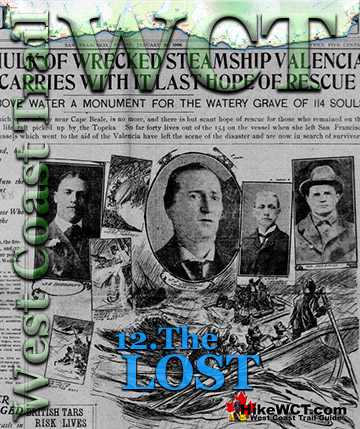
Looking out to the open ocean the cave has the feel of a pirate movie or shipwreck saga. When someone eventually makes a movie about the Valencia shipwreck, which seems inevitable as the events were extraordinary, this place would be a wonderful setting for a lifeboat coming ashore. There was a story told by some locals in the years after the Valencia shipwreck of finding a lifeboat full of skeletons in a cave near the wreck. Michael Neitzel, author of The Final Voyage of the Valencia is currently in the process of making a documentary about the Valencia.

Owen Point Cave Ocean View

Impossibly Beautiful Owen Point Cave at 67km West Coast Trail
It is amazing to see the rainforest pouring out of every crevasse and angle of the rock. The smooth rock that is plant free is polished by the ocean, far inside hidden from the sun.

Deep Inside Owen Point Cave
As you back up to the end of the cave it arches over your head and you get an impressive look at the beautiful curves in the rock carved out by the ocean.

Cave View of Owen Island
Through the narrow gap you get your first view from the inside of the cave. Dark and rounded smooth sandstone gives off a greenish glow from the neon slime the coats some of the walls. You get the ominous feeling that you are inside a whale, looking out of its enormous mouth. Looking down the water flows calmly in and out, crashing lightly over the half submerged little reef at the opening of the cave. A couple hundred metres beyond you see the smooth, lifeless table top of Owen Island.

Owen Point Cave Exit View
On a sunny day the little Owen Point beach is spectacular. Directly ahead is the Port of San Juan, the ocean channel that leads to Port Renfrew. Botanical Beach is just beyond in the distance to the far right of the picture. The smooth, green slope on the right is the route down to the beach from Owen Point where you just crossed over the Owen Point cave. All around you is the bright green glow from sunlight reflecting off the rock and rainforest behind and above you. Though the sunny day in May is only 17c, this protected oasis feels much warmer. The West Coast Trail has countless hidden corners of paradise like this. On first glance they are a far cry from the perfect white sandy beaches of Hawaii, but they have a different kind of captivating beauty about them. Maybe it is the messy, randomness about them. Rocky reefs and boulders jutting out of the ocean. An explosion of rainforest at your back arching above your head. And the constant curiosity you get while hiking along the West Coast Trail, when you never quite know what hides around the next bend in the beach or trail. When you are constantly surprised by one new beach radically different than the last, you can't help but be caught off guard and captivated by the hostile beauty of your newly discovered little corner of paradise.

Owen Beach Trees Hiding the Cave Entrance
Looking back at Owen Point and the big Owen Point cave you just emerged from, you find it completely hidden by the rainforest spilling over the cliffs. The shadowy gap nearest the rocky slope in the left side of the picture below is where the cave hides.

Little Islands Near 68km West Coast Trail
The little island in the distance from Owen Point is actually two tiny islands.

Rocky Beach Route Near 69km
The rocky coastline takes on a new appearance at 69km. More boulders and no smooth rock anywhere.

Thrasher Cove Campsite at 70k
![]() Thrasher Cove has a lot of good aspects as well as some bad. In terms of good, the beach is very pretty and quite interesting. Not a broad and long beach, the beach at Thrasher Cove is quite varied with rock outcrops and constant bends. You can easily keep yourself amused by wandering down the beach, poking your head around every new corner. Back at the campsite, the beach tent sites are backed by an alarmingly abrupt ascent to the main trail. The outhouses at Thrasher Cove are perched up in the trees above the beach and looking around, you feel the embrace of the trees all around giving just narrow glimpses of the ocean. As for bad, Thrasher Cove is generally crowded with fellow campers, and you may find yourselves elbow to elbow with a dozen or more tents in an increasingly confined area. The problem, of course is the narrow beach and abrupt cliff at your back. This does, however, give you a wonderful feeling of how the West Coast Trail truly is. Wild rainforest behind you with ladders attached to the steep terrain and a beautiful ocean in front of you.
Thrasher Cove has a lot of good aspects as well as some bad. In terms of good, the beach is very pretty and quite interesting. Not a broad and long beach, the beach at Thrasher Cove is quite varied with rock outcrops and constant bends. You can easily keep yourself amused by wandering down the beach, poking your head around every new corner. Back at the campsite, the beach tent sites are backed by an alarmingly abrupt ascent to the main trail. The outhouses at Thrasher Cove are perched up in the trees above the beach and looking around, you feel the embrace of the trees all around giving just narrow glimpses of the ocean. As for bad, Thrasher Cove is generally crowded with fellow campers, and you may find yourselves elbow to elbow with a dozen or more tents in an increasingly confined area. The problem, of course is the narrow beach and abrupt cliff at your back. This does, however, give you a wonderful feeling of how the West Coast Trail truly is. Wild rainforest behind you with ladders attached to the steep terrain and a beautiful ocean in front of you.
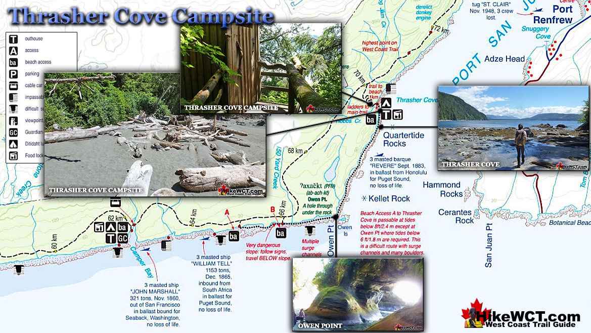
Thrasher Cove Beach Campsite at 69km
Thrasher Cove has a nice sandy beach and a small creek nearby. It is just 6 kilometres from the Gordon River trailhead that it seems like a good campsite to skip. One drawback is that it is too close to civilization and you see passing boats all the time.

Thrasher Cove Ladders Up Into the Rainforest
Thrasher Cove has a very impressive ladder network that ascends quickly up the most lush rainforest. The ladders go up a very steep cliff to the plateau way up in the forest where the forest trails branch off. The terrain is so steep that the outhouse for the campsite is located on the only small area of flat ground on the edge of a cliff. This might be the best outhouse in the world. First class West Coast Trail style, immersed in amazing rainforest and a beautiful ocean view through the trees.


Camper Cove to Gordon River Trailhead in One Day
Many West Coast Trail hikers continue past Thrasher Cove and continue to the Gordon River trailhead. The distance is a little over 5 kilometres and all of it a challenging inland trail. Lots of ups and downs, mud and ladders. Not nearly as difficult as the previous days between Walbran Creek and Camper Bay. Aside from Thrasher Cove being usually crowded and lacking in fresh water, it feels too close to the end(or start) of the trail. If you are hiking south, it feels strange to not just continue to the end and celebrate with a nice meal and possibly a comfy bed later. If you are hiking north, stopping to camp at Thrasher Cove doesn't feel like you have covered much of the trail. Not least because you stare across to Port Renfrew from the campsite!
There are two very important considerations to keep in mind if you hike Camper Bay to Thrasher in one day. It is highly recommended to hike the beach route as it is considerably easier and stunningly beautiful. You are at the mercy of the Gordon River ferry crossing schedule. Theoretically if you miss the last ferry across you can get stranded. You don't want to make it all the way to the end and miss your ride across to civilization. There are pretty regular boats passing by, especially in the summer and in the evening. So getting a ride across can't be that difficult, but you by no means can count on that. Check the ferry crossing schedule that you will get when you start the trail. In the past years he finishes at about 430pm everyday.
If you are hiking from the Gordon River trailhead to Camper Bay on your first night, you have to know the tides. You can't take the beautiful beach route from Thrasher to Camper Bay when the tide is high. So about half of every day the route is blocked by impassible sections of ocean. You can easily hike the land route and not worry about the tides, but the land route is not as interesting or scenic. If you can't make the beach route on your first day, then camping at Thrasher Cove would be well worth it. The beach route is very nice and you can take your time and enjoy the countless views and sights.
Last 5km from Thrasher Cove to Gordon River
The last 5 kilometres from Thrasher Cove to Gordon River is fairly challenging with lots of ups and downs and ladders.

Donkey Engine at 71km
Another abandoned donkey engine appears at 71km. These big machines pulled steel cables attached to cut trees and pulled them out of the forest to trucks or ships nearby.

Crazy West Coast Trail Ladders at 72km
The huge ladders are an amazing part of the West Coast Trail and there is always some excitement when you reach one, wondering where it goes.

More Crazy West Coast Trail Ladders at 73km
The last big ladder at 73km is hilarious with its abrupt end and descent into the forest below.

Bridge Over Deep Ravine at 73km
The bridge at 73km crosses a deep ravine and you start to wonder how many bridges you have crossed in the previous 73km to get here.

The End of the West Coast Trail at 75km
The wonderfully abrupt end to the West Coast Trail at Gordon River. You have to raise a signal buoy to attract the attention of the boatman across the river. When he spots it he motors over and ferries you across to the Port Renfrew side of the river.

West Coast Trail Day 1: Pachena to Darling
The West Coast Trail by Day

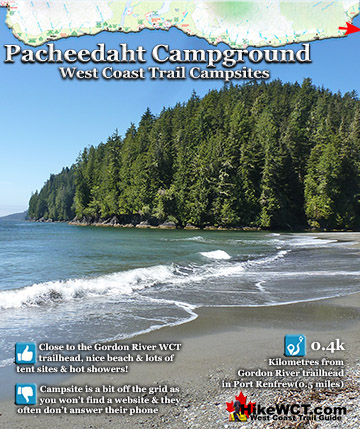
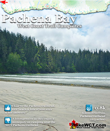
West Coast Trail Campsites
The Valencia Disaster
Explore BC Hiking Destinations!
The West Coast Trail
Victoria Hiking Trails
Clayoquot Hiking Trails
Whistler Hiking Trails
Squamish Hiking Trails

Vancouver Hiking Trails