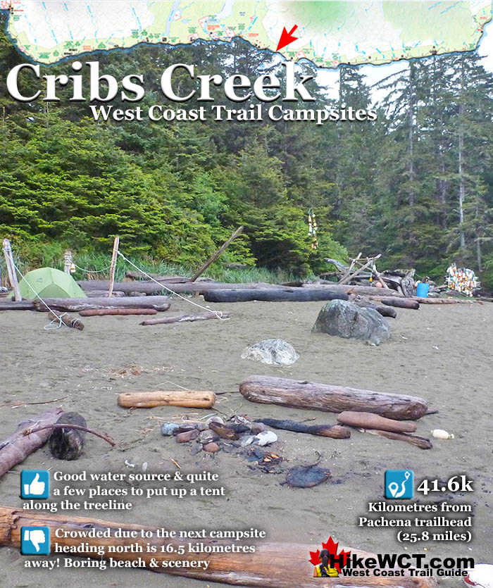
![]() Cribs Creek at 42k of the West Coast Trail is a beautiful, clean, and surprisingly emerald coloured creek that flows through the messy, beach campsite. The pretty creek is about the only nice part about this campsite. The beach is not great, it smells of ageing seaweed, the sandy beach has patches of grass and bushes that give it a messy feel.
Cribs Creek at 42k of the West Coast Trail is a beautiful, clean, and surprisingly emerald coloured creek that flows through the messy, beach campsite. The pretty creek is about the only nice part about this campsite. The beach is not great, it smells of ageing seaweed, the sandy beach has patches of grass and bushes that give it a messy feel.
 Cribs Creek is quite nice, flowing through the campsite
- Decent sandy beach perfect for a campfire
- Popular campsite lets you meet lots of WCT hikers
- Next campsite heading north is 17k away!
 Always overcrowded with tents and hikers
- The beach is ugly compared to other WCT beaches
- Beach tent sites are limited and bunched together
- Rocky shoreline is not inviting to walk along
- Firewood is scarce late in the season
- Crowded campsite ruins the serenity of the beach
West Coast Trail Campsites
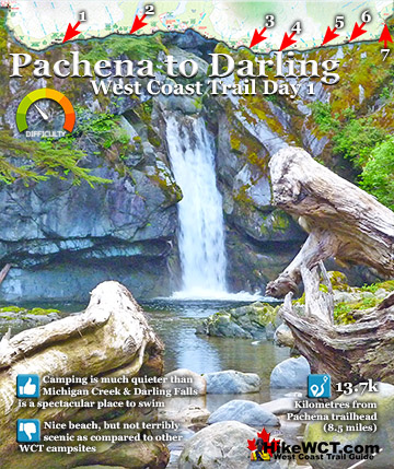
![]() Michigan Creek at 12km
Michigan Creek at 12km ![]() Darling River at 14km
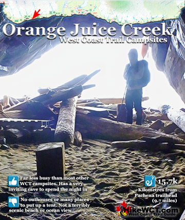
Darling River at 14km ![]() Orange Juice Creek at 15km
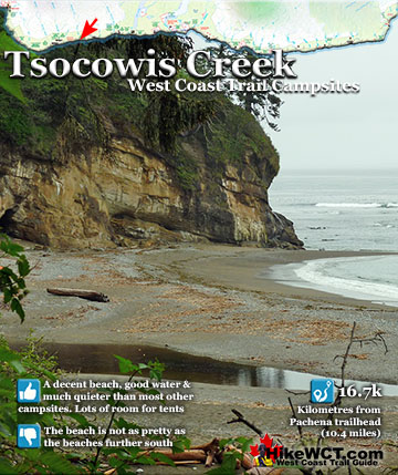
Orange Juice Creek at 15km ![]() Tsocowis Creek at 16.5km
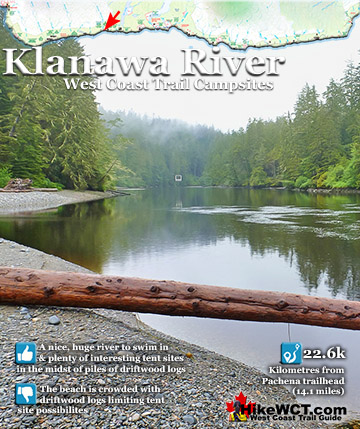
Tsocowis Creek at 16.5km ![]() Klanawa River at 23km
Klanawa River at 23km ![]() Tsusiat Falls at 25km
Tsusiat Falls at 25km ![]() Cribs Creek at 42km
Cribs Creek at 42km ![]() Carmanah Creek at 46km
Carmanah Creek at 46km ![]() Bonilla Creek at 48km
Bonilla Creek at 48km ![]() Walbran Creek at 53km
Walbran Creek at 53km ![]() Cullite Cove at 58km
Cullite Cove at 58km ![]() Camper Bay at 62km
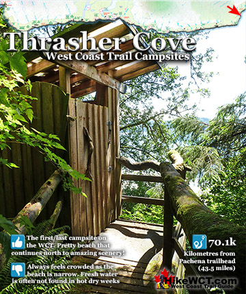
Camper Bay at 62km ![]() Thrasher Cove at 70km
Thrasher Cove at 70km
Unlike many other beaches on the West Coast Trail where you have long sandy beaches carved out by the ocean in giant arcs. At Cribs Creek, you find an irregular and not very attractive beach setting. Still, a nice atmosphere can be created. A lively campfire and a West Coast Trail sunset turns this mediocre beach into decent place to get some rest. Certainly the biggest drawback to Cribs Creek is how busy it always is. Owing to its great distance to the next campsite to the north, Tsusiat Falls, everyone seems to camp here. And they camp here after quite a long day of hiking. Unlike Tsusiat Falls campers, who tend to marvel at the ocean view or stunning waterfalls, at Cribs Creek you find campers busy and focussed on camping and cooking. Skipping Cribs creek as a campsite is recommended. Carmanah Creek campsite is just 4 kilometres away and considerably nicer and quieter. You should try your best to exclude Cribs Creek from one of your campsites on the West Coast Trail. The Carmanah Creek campsite is infinitely nicer if you can manage the extra 4 kilometres of relatively easy beach walking.

Shipwrecks Near Cribs Creek on the West Coast Trail
The Santa Rita Shipwreck Near KM37
![]() Near the 37 kilometre mark on the West Coast Trail you will pass the Santa Rita, a 100 year old shipwreck hidden under the waves. The Santa Rita was a steel steam schooner, built in San Francisco in 1913. On February 15th, 1923 at 520am, this 235 foot long, 1600 ton ship collided head on with the the small island reef just a few hundred metres from the beach. The Santa Rita was sailing in from San Pedro, California, in ballast for a port in the Puget Sound. In stormy weather and blindly navigating in poor visibility, the Carmanah Point Lighthouse was mistaken for the Cape Flattery Lighthouse on Tatoosh Island. The Carmanah Point Lighthouse is along the West Coast Trail and the Cape Flattery Lighthouse is 24.5 kilometres across Juan de Fuca Strait in the United States! The crew turned into what they thought was Juan de Fuca Strait and keeping the Cape Flattery Lighthouse on their right. Unfortunately they were about 20 kilometres north of what they thought, and were in fact keeping the Carmanah Point Lighthouse to their right and sailing directly at Vancouver Island. At 520am on February 15th, 1923 the Santa Rita collided head on into a small offshore reef just a few hundred metres from the West Coast Trail. The large ship, must have been sailing at quite a speed owing to the crew's reckoning that they were entering Juan de Fuca Strait. The sudden impact must have been horrific, loud, and completely unwarned. In the next few hours the entire crew of 30 escaped the wreck via breeches buoy. A breeches buoy is a rope based rescue system where a line runs from the ship to the shore and survivors ride in a flotation ring and leg harness.
Near the 37 kilometre mark on the West Coast Trail you will pass the Santa Rita, a 100 year old shipwreck hidden under the waves. The Santa Rita was a steel steam schooner, built in San Francisco in 1913. On February 15th, 1923 at 520am, this 235 foot long, 1600 ton ship collided head on with the the small island reef just a few hundred metres from the beach. The Santa Rita was sailing in from San Pedro, California, in ballast for a port in the Puget Sound. In stormy weather and blindly navigating in poor visibility, the Carmanah Point Lighthouse was mistaken for the Cape Flattery Lighthouse on Tatoosh Island. The Carmanah Point Lighthouse is along the West Coast Trail and the Cape Flattery Lighthouse is 24.5 kilometres across Juan de Fuca Strait in the United States! The crew turned into what they thought was Juan de Fuca Strait and keeping the Cape Flattery Lighthouse on their right. Unfortunately they were about 20 kilometres north of what they thought, and were in fact keeping the Carmanah Point Lighthouse to their right and sailing directly at Vancouver Island. At 520am on February 15th, 1923 the Santa Rita collided head on into a small offshore reef just a few hundred metres from the West Coast Trail. The large ship, must have been sailing at quite a speed owing to the crew's reckoning that they were entering Juan de Fuca Strait. The sudden impact must have been horrific, loud, and completely unwarned. In the next few hours the entire crew of 30 escaped the wreck via breeches buoy. A breeches buoy is a rope based rescue system where a line runs from the ship to the shore and survivors ride in a flotation ring and leg harness.
Santa Rita shipwreck continued here...
The Dare Shipwreck Near KM39
![]() You will pass the Dare shipwreck near the 39 kilometre mark of the West Coast Trail. The Graveyard of the Pacific claimed this 3 masted, 269 ton schooner on December 23rd, 1890. The Dare sailed out of San Francisco in ballast for Tacoma to take on a load of lumber. In the middle of the winter, stormy season along this coast, the Dare was caught in a typically brutal storm. The crew fought the high winds and tumultuous seas driving them towards the unforgiving shore of Vancouver Island. The Dare was smashed on the rock shore just three kilometres west of Carmanah Point Lighthouse. The crew, unhurt from the impact of the ship was able to get ashore relatively easily. Luckily for the crew they were soon met by Indians who resided just down the beach. The good folks that ferry West Coast Trail hikers across Nitinaht Narrows are descendants of the rescuers of the crew of the Dare. They were transported to Victoria by canoe by the natives. Their ship was left smashed on the rocks and what could be salvaged or looted was taken away. Today there are no visible remnants of the Dare shipwreck except one marvellous reminder of this brutal coastline, the ship's anchor. The ship crashed onto the rocks quite a distance from the present location of the anchor. However with no other shipwreck contenders in the area, the anchor West Coast Trail hikers stumble pas here is almost certainly the anchor from the Dare. You will see it just past the 38 kilometre mark of the trail laying on the rocks in plain view. Dare Point begins just as you pass the anchor(if hiking from the Pachena trailhead). Further along you will come to Dare Beach, a nice, though narrow patch of beach in an area almost entirely rocky, unforgiving coastline.
You will pass the Dare shipwreck near the 39 kilometre mark of the West Coast Trail. The Graveyard of the Pacific claimed this 3 masted, 269 ton schooner on December 23rd, 1890. The Dare sailed out of San Francisco in ballast for Tacoma to take on a load of lumber. In the middle of the winter, stormy season along this coast, the Dare was caught in a typically brutal storm. The crew fought the high winds and tumultuous seas driving them towards the unforgiving shore of Vancouver Island. The Dare was smashed on the rock shore just three kilometres west of Carmanah Point Lighthouse. The crew, unhurt from the impact of the ship was able to get ashore relatively easily. Luckily for the crew they were soon met by Indians who resided just down the beach. The good folks that ferry West Coast Trail hikers across Nitinaht Narrows are descendants of the rescuers of the crew of the Dare. They were transported to Victoria by canoe by the natives. Their ship was left smashed on the rocks and what could be salvaged or looted was taken away. Today there are no visible remnants of the Dare shipwreck except one marvellous reminder of this brutal coastline, the ship's anchor. The ship crashed onto the rocks quite a distance from the present location of the anchor. However with no other shipwreck contenders in the area, the anchor West Coast Trail hikers stumble pas here is almost certainly the anchor from the Dare. You will see it just past the 38 kilometre mark of the trail laying on the rocks in plain view. Dare Point begins just as you pass the anchor(if hiking from the Pachena trailhead). Further along you will come to Dare Beach, a nice, though narrow patch of beach in an area almost entirely rocky, unforgiving coastline.
Dare shipwreck continued here...
The Lizzie Marshall Shipwreck Near KM47
![]() Near KM47 along the West Coast Trail you will pass the final resting place of the Lizzie Marshall. On February 7th, 1884, this 434 ton American ship headed out of San Francisco to an unspecified port in British Columbia. Two weeks later she approached Cape Flattery cloaked in a thick fog. Added to that, the wind died and the Lizzie Marshall drifted with the current. Her sails drenched and barely touched by the breeze, she wallowed along for hours until breakers were heard and Bonilla Point lay right in front of them. The crew dropped two anchors and prayed they would hold them off the perilously close rock shelf. The captain launched a lifeboat to row to Neah Bay, 15 miles away, in the hopes of finding a boat to haul them out of danger. Soon the fog cleared and a southwest gale blew in. Straining against the anchors, the Lizzie Marshall held for a while. However on the morning of February 22nd, the anchors began to drag. In a fit of desperation the crew cut the masts and rigging and dumped them overboard. The idea was to reduce the effect of the wind by lowering the ships profile. This had little effect and the wind continued to increase in strength. The anchor chains were straining against the intense weight of the ship and finally snapped. The Lizzie Marshall was swept broadside into the reef with the stern jammed in between a large gap in the rocks. The crew managed to claw their way across the reef to the shore safely. A short time later one of the crew attempted to get back to the ship to retrieve some of his belongings. He drowned in the attempt. Local native arrived on the scene and began scavenging the wreck as the crew watched from the shore. As they scavenged, their boat was smashed against the rocks, leaving them stranded as well. Eventually a tug arrived on the scene to rescue the crew and natives.
Near KM47 along the West Coast Trail you will pass the final resting place of the Lizzie Marshall. On February 7th, 1884, this 434 ton American ship headed out of San Francisco to an unspecified port in British Columbia. Two weeks later she approached Cape Flattery cloaked in a thick fog. Added to that, the wind died and the Lizzie Marshall drifted with the current. Her sails drenched and barely touched by the breeze, she wallowed along for hours until breakers were heard and Bonilla Point lay right in front of them. The crew dropped two anchors and prayed they would hold them off the perilously close rock shelf. The captain launched a lifeboat to row to Neah Bay, 15 miles away, in the hopes of finding a boat to haul them out of danger. Soon the fog cleared and a southwest gale blew in. Straining against the anchors, the Lizzie Marshall held for a while. However on the morning of February 22nd, the anchors began to drag. In a fit of desperation the crew cut the masts and rigging and dumped them overboard. The idea was to reduce the effect of the wind by lowering the ships profile. This had little effect and the wind continued to increase in strength. The anchor chains were straining against the intense weight of the ship and finally snapped. The Lizzie Marshall was swept broadside into the reef with the stern jammed in between a large gap in the rocks. The crew managed to claw their way across the reef to the shore safely. A short time later one of the crew attempted to get back to the ship to retrieve some of his belongings. He drowned in the attempt. Local native arrived on the scene and began scavenging the wreck as the crew watched from the shore. As they scavenged, their boat was smashed against the rocks, leaving them stranded as well. Eventually a tug arrived on the scene to rescue the crew and natives.
Lizzie Marshall shipwreck continued here...
The Puritan Shipwreck Near KM48.5
![]() The Puritan was a 4 masted schooner of 614 tons sailing inbound from San Francisco in ballast. She was heading for Port Gamble in Washington to pick up a load of lumber when the crew failed to account for the strong current in Juan de Fuca Strait. Owing to the thick fog and heavy seas, the Puritan stumbled blindly into the rocks of Bonilla Point. The crew of 10 made the same mistake that hundreds of crews before them made. They didn't reckon their course with the notorious, strong current of the Juan de Fuca Strait. The current pushed them far northwest of their perceived position. Unable to see due to the thick fog, stormy weather and darkness of night the Puritan was pushed into the rocky Bonilla Point. The record shows that she was wrecked at 5am on November 13, 1896. The crew decided to wait for daybreak to figure out their escape. When the morning finally came, a lone Indian found them and battling the surf, managed to run a rope from the ship to the shore. The crew used the life-line to escape the crumbling ship. The Puritan, continuously bashed by the sea until on the following day she was laying her masts in the surf, and quickly began breaking up. The crew made their way to the Carmanah Point Lighthouse and later ferried to Victoria. For his heroic efforts, the Indian was reportedly rewarded. Today hiking the West Coast Trail, you will find some of the ship's remains on the outer reef.
The Puritan was a 4 masted schooner of 614 tons sailing inbound from San Francisco in ballast. She was heading for Port Gamble in Washington to pick up a load of lumber when the crew failed to account for the strong current in Juan de Fuca Strait. Owing to the thick fog and heavy seas, the Puritan stumbled blindly into the rocks of Bonilla Point. The crew of 10 made the same mistake that hundreds of crews before them made. They didn't reckon their course with the notorious, strong current of the Juan de Fuca Strait. The current pushed them far northwest of their perceived position. Unable to see due to the thick fog, stormy weather and darkness of night the Puritan was pushed into the rocky Bonilla Point. The record shows that she was wrecked at 5am on November 13, 1896. The crew decided to wait for daybreak to figure out their escape. When the morning finally came, a lone Indian found them and battling the surf, managed to run a rope from the ship to the shore. The crew used the life-line to escape the crumbling ship. The Puritan, continuously bashed by the sea until on the following day she was laying her masts in the surf, and quickly began breaking up. The crew made their way to the Carmanah Point Lighthouse and later ferried to Victoria. For his heroic efforts, the Indian was reportedly rewarded. Today hiking the West Coast Trail, you will find some of the ship's remains on the outer reef.
Puritan shipwreck continued here...
The Wempe Brothers Shipwreck Near KM49.4
![]() The Wempe Brothers was a 4 masted schooner just 70 tons heavier than the Puritan, that wrecked here a century ago. The Wempe Brothers was sailing in from San Pedro, California in ballast. She was heading for Puget Sound to pick up lumber when she was claimed by the Graveyard of the Pacific. The crew of 10 experienced very stormy weather as she neared the Cape Flattery Lighthouse and entrance to Juan de Fuca Strait. Light winds and thick fog carried them towards the strait, however the fast current pulled them irresistibly north towards the coast of Vancouver Island. The Wempe Brothers was carried so close to Carmanah Point Lighthouse that the lighthouse lights were reported to be reflected on the ships sails and hull. The crew had no idea they were so far out of their intended position and the sudden appearance of a lighthouse must have been terrifying. The wind was dead calm so sailing to safety was not an option. The crew managed to drop two anchors in a desperate effort to halt the ship before colliding with the shore. It was too late, however, as the Wempe Brothers was carried onto the beach at 5am on October 28th, 1903.
The Wempe Brothers was a 4 masted schooner just 70 tons heavier than the Puritan, that wrecked here a century ago. The Wempe Brothers was sailing in from San Pedro, California in ballast. She was heading for Puget Sound to pick up lumber when she was claimed by the Graveyard of the Pacific. The crew of 10 experienced very stormy weather as she neared the Cape Flattery Lighthouse and entrance to Juan de Fuca Strait. Light winds and thick fog carried them towards the strait, however the fast current pulled them irresistibly north towards the coast of Vancouver Island. The Wempe Brothers was carried so close to Carmanah Point Lighthouse that the lighthouse lights were reported to be reflected on the ships sails and hull. The crew had no idea they were so far out of their intended position and the sudden appearance of a lighthouse must have been terrifying. The wind was dead calm so sailing to safety was not an option. The crew managed to drop two anchors in a desperate effort to halt the ship before colliding with the shore. It was too late, however, as the Wempe Brothers was carried onto the beach at 5am on October 28th, 1903.
Wempe Brothers shipwreck continued here...
![]() Santa Rita at 37k
Santa Rita at 37k ![]() Dare at 39k
Dare at 39k ![]() Lizzie Marshall at 47k
Lizzie Marshall at 47k ![]() Puritan at 48.5k
Puritan at 48.5k ![]() Wempe Brothers at 49.4k
Wempe Brothers at 49.4k
More West Coast Trail Campsites
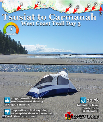
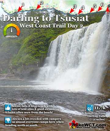
Tsusiat Falls Campsite at 25km
![]() One of the most popular and beautiful campsites along the West Coast Trail. Tsusiat Falls is one of the main highlights on the trail with its dramatically wide and beautifully picturesque appearance. You will find Tsusiat Falls at the base of an extraordinary array of ladders extending hundreds of metres up into the trees. Tsusiat Falls pours over an abrupt and wide cliff onto the sandy beach. The force of the water has dug out quite a large pool that flows in an ever changing channel through the sand to the ocean. It is quite common to see whales passing in the distance from the beach at Tsusiat. The beach is raised up a few metres from the ocean and affords you a better vantage point over the ocean than you get elsewhere. Tsusiat Falls campsite is wide and extends as far as you want to go down the beach. As everyone has seen pictures of it, everyone aims for it to spend the night. If you don't mind crowds then you'll love it. If you don't like crowds, you may have trouble finding a serene corner to camp. If you really want to find serenity, you might try camping at the far end of the beach where you will find quite a large sea cave. If you love waking up to whales in the distance and the beautiful roar of waterfalls nearby, then you will find that at Tsusiat. The campsite is well designed for crowds though as the hundreds of driftwood logs on the beach have fashioned partitioned areas randomly, where some sort of organized privacy exists.
One of the most popular and beautiful campsites along the West Coast Trail. Tsusiat Falls is one of the main highlights on the trail with its dramatically wide and beautifully picturesque appearance. You will find Tsusiat Falls at the base of an extraordinary array of ladders extending hundreds of metres up into the trees. Tsusiat Falls pours over an abrupt and wide cliff onto the sandy beach. The force of the water has dug out quite a large pool that flows in an ever changing channel through the sand to the ocean. It is quite common to see whales passing in the distance from the beach at Tsusiat. The beach is raised up a few metres from the ocean and affords you a better vantage point over the ocean than you get elsewhere. Tsusiat Falls campsite is wide and extends as far as you want to go down the beach. As everyone has seen pictures of it, everyone aims for it to spend the night. If you don't mind crowds then you'll love it. If you don't like crowds, you may have trouble finding a serene corner to camp. If you really want to find serenity, you might try camping at the far end of the beach where you will find quite a large sea cave. If you love waking up to whales in the distance and the beautiful roar of waterfalls nearby, then you will find that at Tsusiat. The campsite is well designed for crowds though as the hundreds of driftwood logs on the beach have fashioned partitioned areas randomly, where some sort of organized privacy exists.


Tsusiat Falls campsite continued here...
Carmanah Creek Campsite at 46km
![]() Carmanah Creek campsite is at the 46k mark of the West Coast Trail. The lovely and large Carmanah Creek slowly flows through this wonderfully massive and very beautiful beach. Plenty of room for plenty of tents. This is one of the beaches that makes you drop your pack, sit on the warm sand and gaze out at the ocean dumbfounded for minutes at a time. The West Coast Trail is something special! There is no shortage of great spots on the beach to put up your tent. You can even put up your tent along the river on the lovely sandy bank. Everybody camps at the unimpressive Cribs Creek campsite just 4 kilometres away, leaving Carmanah Creek a serene paradise. This is one of the campsites where you will want to stay for days, so you might want to include that in your itinerary!
Carmanah Creek campsite is at the 46k mark of the West Coast Trail. The lovely and large Carmanah Creek slowly flows through this wonderfully massive and very beautiful beach. Plenty of room for plenty of tents. This is one of the beaches that makes you drop your pack, sit on the warm sand and gaze out at the ocean dumbfounded for minutes at a time. The West Coast Trail is something special! There is no shortage of great spots on the beach to put up your tent. You can even put up your tent along the river on the lovely sandy bank. Everybody camps at the unimpressive Cribs Creek campsite just 4 kilometres away, leaving Carmanah Creek a serene paradise. This is one of the campsites where you will want to stay for days, so you might want to include that in your itinerary!


Carmanah Creek campsite continued here...
Bonilla Creek Campsite at 48km
![]() Bonilla Creek at 48k The Bonilla Creek campsite is easy to miss, as it looks very unassuming from the beach as most hikers pass by. Bonilla Falls, however is nestled against a small cliff at the edge of a suddenly deep forest. And the forest hides a nice little world, somewhat sheltered from the elements. An outhouse sits up at the far end, and several tent clearings stretch to the beach where you find a wonderful hammock cobbled together over the years out of old fishing nets and ropes. A bit surreal in such a remote feeling place, but it is so elaborate that it makes you look around for permanent residents! You won't find any permanent human residents, however, you will encounter some wildlife as there always seems to be a bear or two walking the shoreline between Bonilla Point and Carmanah Creek in the early morning hours. The campsite at Bonilla Creek has some beautiful characteristics. First the cute, Bonilla Falls have a perfect little pool to swim in and wash off the days hiking grime. Second, the campsite is quite good with lots of varied places to put up a tent as well as some driftwood structures out on the beach. Third, the sunsets are sensational here. Bright orange, with the narrow islands in the distance topped by improbable looking trees. Added to that, you have a relatively quiet campsite compared to other West Coast Trail campsites.
Bonilla Creek at 48k The Bonilla Creek campsite is easy to miss, as it looks very unassuming from the beach as most hikers pass by. Bonilla Falls, however is nestled against a small cliff at the edge of a suddenly deep forest. And the forest hides a nice little world, somewhat sheltered from the elements. An outhouse sits up at the far end, and several tent clearings stretch to the beach where you find a wonderful hammock cobbled together over the years out of old fishing nets and ropes. A bit surreal in such a remote feeling place, but it is so elaborate that it makes you look around for permanent residents! You won't find any permanent human residents, however, you will encounter some wildlife as there always seems to be a bear or two walking the shoreline between Bonilla Point and Carmanah Creek in the early morning hours. The campsite at Bonilla Creek has some beautiful characteristics. First the cute, Bonilla Falls have a perfect little pool to swim in and wash off the days hiking grime. Second, the campsite is quite good with lots of varied places to put up a tent as well as some driftwood structures out on the beach. Third, the sunsets are sensational here. Bright orange, with the narrow islands in the distance topped by improbable looking trees. Added to that, you have a relatively quiet campsite compared to other West Coast Trail campsites.


Bonilla Creek campsite continued here...
Best West Coast Trail Sights & Highlights

West Coast Trail Campsites
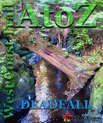
West Coast Trail A to Z
The West Coast Trail by Day

Explore BC Hiking Destinations!
The West Coast Trail
Victoria Hiking Trails

Clayoquot Hiking Trails

Whistler Hiking Trails
Squamish Hiking Trails

Vancouver Hiking Trails