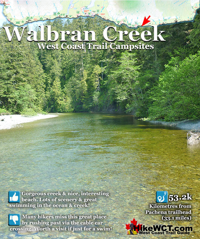
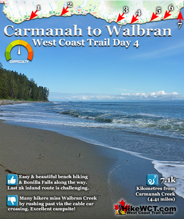
![]() Walbran Creek at 53k is home to possibly the best, and most unappreciated campsites on the West Coast Trail. The Walbran Creek campsite encapsulates so much that makes the West Coast Trail truly wonderful. The expansive beach which seems purpose built for enjoyability is flanked by scenic cliffs and creek on one side, the pacific ocean on the other, and backed by the emerald coloured Walbran Creek that flows through the jungle valley spanned by a cable car crossing!
Walbran Creek at 53k is home to possibly the best, and most unappreciated campsites on the West Coast Trail. The Walbran Creek campsite encapsulates so much that makes the West Coast Trail truly wonderful. The expansive beach which seems purpose built for enjoyability is flanked by scenic cliffs and creek on one side, the pacific ocean on the other, and backed by the emerald coloured Walbran Creek that flows through the jungle valley spanned by a cable car crossing!
 Nice, spacious beach and great ocean views
- Walbran Creek is big, beautiful and inviting
- Interesting beach with lots to explore
- Going for a swim is close and excellent
- Tent sites are often walled by driftwood
- Most hikers don't camp or even stop here!
- Finding a great tent site is easy
- Beach has a great view across to the US
- Cable car crossing is very fun and very long
 If the beach was white sand, it would be perfect
West Coast Trail Campsites
![]() Michigan Creek at 12km
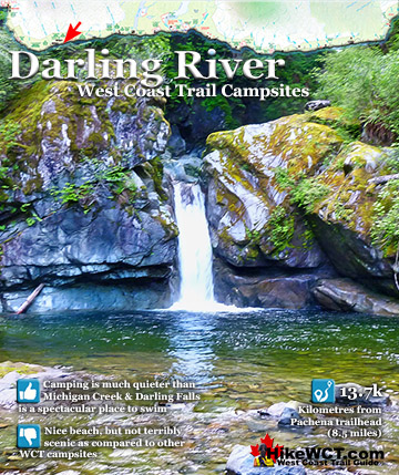
Michigan Creek at 12km ![]() Darling River at 14km
Darling River at 14km ![]() Orange Juice Creek at 15km
Orange Juice Creek at 15km ![]() Tsocowis Creek at 16.5km
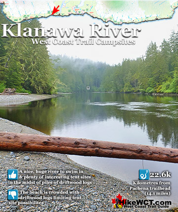
Tsocowis Creek at 16.5km ![]() Klanawa River at 23km
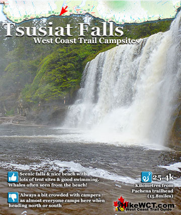
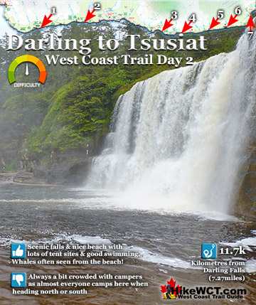
Klanawa River at 23km ![]() Tsusiat Falls at 25km
Tsusiat Falls at 25km ![]() Cribs Creek at 42km
Cribs Creek at 42km ![]() Carmanah Creek at 46km
Carmanah Creek at 46km ![]() Bonilla Creek at 48km
Bonilla Creek at 48km ![]() Walbran Creek at 53km
Walbran Creek at 53km ![]() Cullite Cove at 58km
Cullite Cove at 58km ![]() Camper Bay at 62km
Camper Bay at 62km ![]() Thrasher Cove at 70km
Thrasher Cove at 70km
Of the list of pro's and con's for Walbran Creek, the list is hopelessly lopsided to the pro's. Walbran Creek campsite is reached in the middle of the most challenging, invigorating, stunning, bewildering and breathtaking section of the West Coast Trail. The ladders you encounter heading either direction from the campsite are astounding in size. One after another you ascend and descend the most improbably long and slippery, wooden ladders that always feel solid and safe, despite their obvious age and weathering. Even the cable car crossing is exhilerating. It is a very long one and this one in particular invites you to stop midway and take in the stunning view in either direction. Upstream the view is an emerald coloured creek(though it looks more like a river in size), flanked by a beautifully tangled rainforest jungle on either side. The view in the other direction is of the Pacific Ocean framed by trees on either side. Though this image is pretty, it doesn't reveal the true beauty of the campsite that spills out along the beach, just out of view. For most, this cable car glimpse is the closest they get to the Walbran Creek campsite. Such a shame as they are passing a little piece of West Coast Trail paradise. If you do venture down the short side trail to the campsite, almost entirely on the beach you will be instantly surprised by the beach of weather rounded rocks and maze of driftwood logs. Though a beautiful, sandy beach may be your ideal, a pebble beach is a close second.
Beautiful Walbran Creek Campsite
![]() Clean and tidy, you don't get a sleeping bag full of sand. The driftwood logs are semi permanent and have been adjusted over time to create what might be called bedrooms. Little, marvelously segregated, sandy patches ideal for tents. You could be 10 metres from your neighbour and the wall of driftwood logs blocks the sight and sound you might get from others. So you have privacy, which you may not need as Walbran Creek is one of the less visited campsites on the West Coast Trail and where you may find dozens of tents at Tsusiat Falls or Camper Bay. At Walbran Creek you may encounter nobody!
Clean and tidy, you don't get a sleeping bag full of sand. The driftwood logs are semi permanent and have been adjusted over time to create what might be called bedrooms. Little, marvelously segregated, sandy patches ideal for tents. You could be 10 metres from your neighbour and the wall of driftwood logs blocks the sight and sound you might get from others. So you have privacy, which you may not need as Walbran Creek is one of the less visited campsites on the West Coast Trail and where you may find dozens of tents at Tsusiat Falls or Camper Bay. At Walbran Creek you may encounter nobody!

Added to the serenity, you get the ever-present ocean view in front of you. The United States is easily visibly across Juan de Fuca Strait, and you can imagine the ships just a century ago reaching Cape Flattery, the point of land in the US, across from you extending into the Pacific. Often sailing up from San Francisco in calm weather, only to reach Cape Flattery and get hit by a winter storm that batters your ship and blinds you in fog. You then creep into what you think is Juan de Fuca Strait towards Puget Sound, Victoria or Vancouver, when in fact the strong current has brought you into the teeth of the Graveyard of the Pacific. Hundreds of ships were driven into the rocky flank of Vancouver Island and became victims of this treacherous corner of the world. This sinister past of course necessitated the creation of the West Coast Trail which would go on to save hundreds of shipwreck survivors and in 1970 become an officially defined national park.

At the end of a long day hiking the West Coast Trail, having a nice body of water to wash in.. or better yet jump into is always desired. Walbran Creek flows just steps from your tent, crystal clear, and very inviting. You can swim across the the opposite shore where you will find some small sea caves and a narrow, rocky shore. At the mouth of Walbran Creek, where it meets the ocean you will find a shallow area that is the beach route on the West Coast Trail heading north. It does involve crossing water deeper than most feel comfortable with, so you don't often see people use this route. Also, it avoids the very enjoyable cable car crossing. If you are brave and keen to plunge into the wild Pacific Ocean, you are just steps from that too. You walk straight into the ocean and meet some big breakers. Feel what all the shipwreck survivors felt, scrambling to safety after emerging from the Graveyard of the Pacific. You can plunge into the ocean, then plunge into Walbran Creek moments later as they are separated by a narrow section of beach. 
Shipwrecks Near Walbran Creek on the West Coast Trail
The Puritan Shipwreck at 48.5km
![]() The Puritan was a 4 masted schooner of 614 tons sailing inbound from San Francisco in ballast. She was heading for Port Gamble in Washington to pick up a load of lumber when the crew failed to account for the strong current in the Juan de Fuca Strait. Owing to the thick fog and heavy seas, the Puritan stumbled blindly into the rocks of Bonilla Point. The crew of 10 made the same mistake that hundreds of crews before them made. They didn't reckon their course with the notorious, strong current of the Juan de Fuca Strait. The current pushed them far northwest of their perceived position. Unable to see due to the thick fog, stormy weather and darkness of night the Puritan was pushed into the rocky Bonilla Point. The record shows that she was wrecked at 5am on November 13, 1896. The crew decided to wait for daybreak to figure out their escape. When the morning finally came, a lone Indian found them and battling the surf, managed to run a rope from the ship to the shore. The crew used the life-line to escape the crumbling ship. The Puritan, continuously bashed by the sea until on the following day she was laying her masts in the surf, and quickly began breaking up. The crew made their way to the Carmanah lighthouse and later ferried to Victoria. For his heroic efforts, the Indian was reportedly rewarded. Today hiking the West Coast Trail, you will find some of the ship's remains on the outer reef.
The Puritan was a 4 masted schooner of 614 tons sailing inbound from San Francisco in ballast. She was heading for Port Gamble in Washington to pick up a load of lumber when the crew failed to account for the strong current in the Juan de Fuca Strait. Owing to the thick fog and heavy seas, the Puritan stumbled blindly into the rocks of Bonilla Point. The crew of 10 made the same mistake that hundreds of crews before them made. They didn't reckon their course with the notorious, strong current of the Juan de Fuca Strait. The current pushed them far northwest of their perceived position. Unable to see due to the thick fog, stormy weather and darkness of night the Puritan was pushed into the rocky Bonilla Point. The record shows that she was wrecked at 5am on November 13, 1896. The crew decided to wait for daybreak to figure out their escape. When the morning finally came, a lone Indian found them and battling the surf, managed to run a rope from the ship to the shore. The crew used the life-line to escape the crumbling ship. The Puritan, continuously bashed by the sea until on the following day she was laying her masts in the surf, and quickly began breaking up. The crew made their way to the Carmanah lighthouse and later ferried to Victoria. For his heroic efforts, the Indian was reportedly rewarded. Today hiking the West Coast Trail, you will find some of the ship's remains on the outer reef.
Puritan shipwreck continued here...
The Wempe Brothers Shipwreck at 49.4km
![]() The Wempe Brothers was a 4 masted schooner just 70 tons heavier than the Puritan, that wrecked here a century ago. The Wempe Brothers was sailing in from San Pedro, California in ballast. She was heading for Puget Sound to pick up lumber when she was claimed by the Graveyard of the Pacific. The crew of 10 experienced very stormy weather as she neared the Cape Flattery lighthouse and entrance to Juan de Fuca Strait. Light winds and thick fog carried them towards the strait, however the fast current pulled them irresistibly north towards the coast of Vancouver Island. The Wempe Brothers was carried so close to the Carmanah Point that the lighthouse lights were reported to be reflected on the ships sails and hull. The crew had no idea they were so far out of their intended position and the sudden appearance of a lighthouse must have been terrifying. The wind was dead calm so sailing to safety was not an option. The crew managed to drop two anchors in a desperate effort to halt the ship before colliding with the shore. It was too late, however, as the Wempe Brothers was carried onto the beach at 5am on October 28th, 1903.
The Wempe Brothers was a 4 masted schooner just 70 tons heavier than the Puritan, that wrecked here a century ago. The Wempe Brothers was sailing in from San Pedro, California in ballast. She was heading for Puget Sound to pick up lumber when she was claimed by the Graveyard of the Pacific. The crew of 10 experienced very stormy weather as she neared the Cape Flattery lighthouse and entrance to Juan de Fuca Strait. Light winds and thick fog carried them towards the strait, however the fast current pulled them irresistibly north towards the coast of Vancouver Island. The Wempe Brothers was carried so close to the Carmanah Point that the lighthouse lights were reported to be reflected on the ships sails and hull. The crew had no idea they were so far out of their intended position and the sudden appearance of a lighthouse must have been terrifying. The wind was dead calm so sailing to safety was not an option. The crew managed to drop two anchors in a desperate effort to halt the ship before colliding with the shore. It was too late, however, as the Wempe Brothers was carried onto the beach at 5am on October 28th, 1903.
Wempe Brothers shipwreck continued here...
The Duchess of Argyle Shipwreck at 58km
![]() The Duchess of Argyle met her end at the mouth of Cullite Cove back at the 58 kilometre mark of the West Coast Trail. She was a huge, four masted barque with an iron hull and watertight bulkheads. She was sailing in ballast from San Francisco on October 13th, 1887, bound for Vancouver. She would pick up lumber and sail for Melbourne, Australia. Sailing up the coast from San Francisco, the good weather turned bad on October 16th. For almost two weeks a powerful gale hammered the Duchess of Argyle. When the storm finally let up, Cape Flattery was sighted about 20 miles away. The ship, unable to find wind, floated with the current, inching towards Juan de Fuca Strait. Soon a small tug boat arrived to assist the enormous becalmed ship through the strait. They lowered sails and got the hawser aboard to connect the ships. The captain of the tug quickly realized that his vessel was too small to manage such a huge ship rolling in the seas. Cape Flattery was still about 14 miles distant and concealed by fog much of the time. The Duchess of Argyle wallowed in the current until midnight when a strong eastward gale gripped the ship once more. They sailed for Cape Flattery until the wind died again and on November 1st the fog lifted revealing Cape Flattery just 3 miles away. Suddenly the fog returned again, thicker than ever. They crawled forward slowly hoping for the fog to lift again. The fog didn't let up and at 315pm on November 3rd, breakers were heard...
The Duchess of Argyle met her end at the mouth of Cullite Cove back at the 58 kilometre mark of the West Coast Trail. She was a huge, four masted barque with an iron hull and watertight bulkheads. She was sailing in ballast from San Francisco on October 13th, 1887, bound for Vancouver. She would pick up lumber and sail for Melbourne, Australia. Sailing up the coast from San Francisco, the good weather turned bad on October 16th. For almost two weeks a powerful gale hammered the Duchess of Argyle. When the storm finally let up, Cape Flattery was sighted about 20 miles away. The ship, unable to find wind, floated with the current, inching towards Juan de Fuca Strait. Soon a small tug boat arrived to assist the enormous becalmed ship through the strait. They lowered sails and got the hawser aboard to connect the ships. The captain of the tug quickly realized that his vessel was too small to manage such a huge ship rolling in the seas. Cape Flattery was still about 14 miles distant and concealed by fog much of the time. The Duchess of Argyle wallowed in the current until midnight when a strong eastward gale gripped the ship once more. They sailed for Cape Flattery until the wind died again and on November 1st the fog lifted revealing Cape Flattery just 3 miles away. Suddenly the fog returned again, thicker than ever. They crawled forward slowly hoping for the fog to lift again. The fog didn't let up and at 315pm on November 3rd, breakers were heard...
Duchess of Argyle shipwreck continued here...
The John Marshall Shipwreck at 62.3km
![]() The John Marshall shipwreck is located under the waves just outside the mouth of Camper Bay at the 62 kilometre mark of the West Coast Trail. Owing to the great difficulty and slow progress hikers are forced to take on this section of the West Coast Trail, nearly everyone camps at Camper Creek. If you do, you will be sleeping near this shipwreck that occurred here in 1860. The John Marshall was an old eastern built, 3 masted ship of 321 tons. Sailing in from San Francisco with a crew of 10, she was heading to Seabeck, Washington in ballast to pick up a load of lumber. Off Cape Flattery the John Marshall met a raging storm that left her beached in front of Camper Bay. There seem to be few details of this shipwreck, however, local natives reported that two ships came ashore from the storm that night. It had been assumed that she foundered off Cape Flattery with no survivors. So it was quite a surprise to find her ashore at Camper Bay, with her hull visible at low tide and her masts, spars and rigging scattered on the beach. There are no details of deaths from this shipwreck, so it is assumed that there was no loss of life.
The John Marshall shipwreck is located under the waves just outside the mouth of Camper Bay at the 62 kilometre mark of the West Coast Trail. Owing to the great difficulty and slow progress hikers are forced to take on this section of the West Coast Trail, nearly everyone camps at Camper Creek. If you do, you will be sleeping near this shipwreck that occurred here in 1860. The John Marshall was an old eastern built, 3 masted ship of 321 tons. Sailing in from San Francisco with a crew of 10, she was heading to Seabeck, Washington in ballast to pick up a load of lumber. Off Cape Flattery the John Marshall met a raging storm that left her beached in front of Camper Bay. There seem to be few details of this shipwreck, however, local natives reported that two ships came ashore from the storm that night. It had been assumed that she foundered off Cape Flattery with no survivors. So it was quite a surprise to find her ashore at Camper Bay, with her hull visible at low tide and her masts, spars and rigging scattered on the beach. There are no details of deaths from this shipwreck, so it is assumed that there was no loss of life.
John Marshall shipwreck continued here...
The William Tell Shipwreck at 64.2km
![]() Less than a kilometre past the John Marshall shipwreck you will pass the William Tell shipwreck. Considerably larger than the John Marshall, the William Tell was a 1153 ton, 3 masted ship that wrecked in the Graveyard of the Pacific on December 23rd, 1865. She sailed straight into the reef in front of what is now the 64 kilometre mark of the West Coast Trail. The William Tell was built in New York in 1850. She sailed in the North Atlantic for a few years before branching out to more distant ports. On her final voyage in 1865, she was inbound from South Africa in ballast, heading to a port in the Puget Sound. She managed to sail into Juan de Fuca Strait, however stormy weather and strong currents moved her considerably far west. Blindly sailing in thick fog and the darkness of night, the William Tell smashed into the reef between Owen Point and Camper Bay. The crew of 22 men managed to scramble safely to shore and made their way to Owen Point where they lit signal fires. Their fires were spotted from the harbour of Port San Juan(Port Renfrew). They were picked up and later brought back to Victoria by a local trading schooner.
Less than a kilometre past the John Marshall shipwreck you will pass the William Tell shipwreck. Considerably larger than the John Marshall, the William Tell was a 1153 ton, 3 masted ship that wrecked in the Graveyard of the Pacific on December 23rd, 1865. She sailed straight into the reef in front of what is now the 64 kilometre mark of the West Coast Trail. The William Tell was built in New York in 1850. She sailed in the North Atlantic for a few years before branching out to more distant ports. On her final voyage in 1865, she was inbound from South Africa in ballast, heading to a port in the Puget Sound. She managed to sail into Juan de Fuca Strait, however stormy weather and strong currents moved her considerably far west. Blindly sailing in thick fog and the darkness of night, the William Tell smashed into the reef between Owen Point and Camper Bay. The crew of 22 men managed to scramble safely to shore and made their way to Owen Point where they lit signal fires. Their fires were spotted from the harbour of Port San Juan(Port Renfrew). They were picked up and later brought back to Victoria by a local trading schooner.
William Tell shipwreck continued here...
West Coast Trail Shipwrecks
![]() Alaskan at 4k
Alaskan at 4k ![]() Soquel at 5k
Soquel at 5k ![]() Sarah at 7k
Sarah at 7k ![]() Becherdass-Ambiadass at 8k
Becherdass-Ambiadass at 8k ![]() Michigan at 12k
Michigan at 12k ![]() Uzbekistan at 13.8k
Uzbekistan at 13.8k ![]() Varsity at 17.6k
Varsity at 17.6k ![]() Valencia at 18.3k
Valencia at 18.3k ![]() Janet Cowan at 19k
Janet Cowan at 19k ![]() Robert Lewers at 20k
Robert Lewers at 20k ![]() Woodside at 20.2k
Woodside at 20.2k ![]() Uncle John at 26.2k
Uncle John at 26.2k ![]() Vesta at 29k
Vesta at 29k ![]() Raita at 33k
Raita at 33k ![]() Skagit at 34.2k
Skagit at 34.2k ![]() Santa Rita at 37k
Santa Rita at 37k ![]() Dare at 39k
Dare at 39k ![]() Lizzie Marshall at 47k
Lizzie Marshall at 47k ![]() Puritan at 48.5k
Puritan at 48.5k ![]() Wempe Brothers at 49.4k
Wempe Brothers at 49.4k ![]() Duchess of Argyle at 58k
Duchess of Argyle at 58k ![]() John Marshall at 62.3k
John Marshall at 62.3k ![]() William Tell at 64.2
William Tell at 64.2 ![]() Revere at 69k
Revere at 69k ![]() Cyrus at 75k
Cyrus at 75k
More West Coast Trail Campsites
Carmanah Creek Campsite at 46km
![]() Carmanah Creek campsite is at the 46k mark of the West Coast Trail. The lovely and large Carmanah Creek slowly flows through this wonderfully massive and very beautiful beach. Plenty of room for plenty of tents. This is one of the beaches that makes you drop your pack, sit on the warm sand and gaze out at the ocean dumbfounded for minutes at a time. The West Coast Trail is something special! There is no shortage of great spots on the beach to put up your tent. You can even put up your tent along the river on the lovely sandy bank. Everybody camps at the unimpressive Cribs Creek campsite just 4 kilometres away, leaving Carmanah Creek a serene paradise. This is one of the campsites where you will want to stay for days, so you might want to include that in your itinerary!
Carmanah Creek campsite is at the 46k mark of the West Coast Trail. The lovely and large Carmanah Creek slowly flows through this wonderfully massive and very beautiful beach. Plenty of room for plenty of tents. This is one of the beaches that makes you drop your pack, sit on the warm sand and gaze out at the ocean dumbfounded for minutes at a time. The West Coast Trail is something special! There is no shortage of great spots on the beach to put up your tent. You can even put up your tent along the river on the lovely sandy bank. Everybody camps at the unimpressive Cribs Creek campsite just 4 kilometres away, leaving Carmanah Creek a serene paradise. This is one of the campsites where you will want to stay for days, so you might want to include that in your itinerary!


Carmanah Creek campsite continued here...
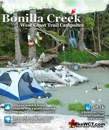
Bonilla Creek Campsite at 48km
![]() Bonilla Creek at 48k The Bonilla Creek campsite is easy to miss, as it looks very unassuming from the beach as most hikers pass by. Bonilla Falls, however is nestled against a small cliff at the edge of a suddenly deep forest. And the forest hides a nice little world, somewhat sheltered from the elements. An outhouse sits up at the far end, and several tent clearings stretch to the beach where you find a wonderful hammock cobbled together over the years out of old fishing nets and ropes. A bit surreal in such a remote feeling place, but it is so elaborate that it makes you look around for permanent residents! You won't find any permanent human residents, however, you will encounter some wildlife as there always seems to be a bear or two walking the shoreline between Bonilla Point and Carmanah Creek in the early morning hours. The campsite at Bonilla Creek has some beautiful characteristics. First the cute, Bonilla Falls have a perfect little pool to swim in and wash off the days hiking grime. Second, the campsite is quite good with lots of varied places to put up a tent as well as some driftwood structures out on the beach. Third, the sunsets are sensational here. Bright orange, with the narrow islands in the distance topped by improbable looking trees. Added to that, you have a relatively quiet campsite compared to other West Coast Trail campsites.
Bonilla Creek at 48k The Bonilla Creek campsite is easy to miss, as it looks very unassuming from the beach as most hikers pass by. Bonilla Falls, however is nestled against a small cliff at the edge of a suddenly deep forest. And the forest hides a nice little world, somewhat sheltered from the elements. An outhouse sits up at the far end, and several tent clearings stretch to the beach where you find a wonderful hammock cobbled together over the years out of old fishing nets and ropes. A bit surreal in such a remote feeling place, but it is so elaborate that it makes you look around for permanent residents! You won't find any permanent human residents, however, you will encounter some wildlife as there always seems to be a bear or two walking the shoreline between Bonilla Point and Carmanah Creek in the early morning hours. The campsite at Bonilla Creek has some beautiful characteristics. First the cute, Bonilla Falls have a perfect little pool to swim in and wash off the days hiking grime. Second, the campsite is quite good with lots of varied places to put up a tent as well as some driftwood structures out on the beach. Third, the sunsets are sensational here. Bright orange, with the narrow islands in the distance topped by improbable looking trees. Added to that, you have a relatively quiet campsite compared to other West Coast Trail campsites.


Bonilla Creek campsite continued here...
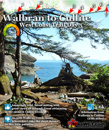
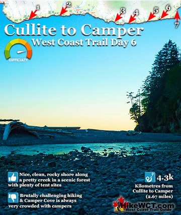
Cullite Cove Campsite at 58km
![]() Cullite Cove is a wonderful campsite on the West Coast Trail at the 58 kilometre mark. Yet another beautiful campsite you will find on the West Coast Trail. It has everything, a lovely wooded area with clearings for tents and campfires. Stunning views all around. A terrific, rocky beach, beautifully hemmed in by beautiful cliffs on either side. Cullite Creek pours into the cove, making for a stunning, albeit freezing swim into the surf. Cullite Cove is a close to perfect as a campsite can get. Cullite Creek is beautiful, crystal clear green, big and slow moving into Cullite Cove, a picture perfect beach hemmed in by majestic cliffs on both sides. Just off the beach, several campsites are laid out, hidden in the trees. Your first thought on seeing this site is to want to stay for a week. The campsite here is often very quiet as everybody seems to camp at Camper Bay just 4 kilometres away and doesn't even drop down the short detour off the main trail to Cullite Cove.
Cullite Cove is a wonderful campsite on the West Coast Trail at the 58 kilometre mark. Yet another beautiful campsite you will find on the West Coast Trail. It has everything, a lovely wooded area with clearings for tents and campfires. Stunning views all around. A terrific, rocky beach, beautifully hemmed in by beautiful cliffs on either side. Cullite Creek pours into the cove, making for a stunning, albeit freezing swim into the surf. Cullite Cove is a close to perfect as a campsite can get. Cullite Creek is beautiful, crystal clear green, big and slow moving into Cullite Cove, a picture perfect beach hemmed in by majestic cliffs on both sides. Just off the beach, several campsites are laid out, hidden in the trees. Your first thought on seeing this site is to want to stay for a week. The campsite here is often very quiet as everybody seems to camp at Camper Bay just 4 kilometres away and doesn't even drop down the short detour off the main trail to Cullite Cove.


Cullite Cove campsite continued here...
Camper Bay Campsite at 62km
![]() Camper Creek is beautiful, similar to Cullilte Cove there are cliffs on either side. The downside is crowding. It's the first really good campsite from the Port Renfrew(Gordon River trailhead) direction. Still, it's spacious and well laid out with the creek cutting along the edge and around to the ocean. Another downside is the proximity of Port Renfrew. It's hard to get the wilderness feeling when you can see boats pass every minute and cruise ships in the distance. Camper Bay is often home to quite a number of campers. You always find the campsite lined with tents along the treeline packed so close together as to hear each others conversations. A bit too cozy, but on the other hand, Camper Bay is a great place to socialize with fellow campers. The linear tent site arrangement make it necessary for you and others to walk past several tents to do almost anything. So you get fairly well acquainted with your fellow West Coast Trail hikers. The trail from Camper Bay in both directions is pretty brutal with ladders and erratic terrain, so you and your fellow campers with be exhausted. Cullite Cove is a wonderful campsite on the West Coast Trail at the 58 kilometre mark. One of the nicest campsites you will find on the West Coast Trail. It has everything, a lovely wooded area with clearings for tents and campfires. Stunning views all around. A terrific, rocky beach, beautifully hemmed in by beautiful cliffs on either side. Cullite Creek pours into the cove, making for a stunning, albeit freezing swim into the surf. The campsite here is often very quiet as everybody seems to camp at Camper Creek just 4 kilometres away and doesn't even drop down the short detour off the main trail to Cullite Cove.
Camper Creek is beautiful, similar to Cullilte Cove there are cliffs on either side. The downside is crowding. It's the first really good campsite from the Port Renfrew(Gordon River trailhead) direction. Still, it's spacious and well laid out with the creek cutting along the edge and around to the ocean. Another downside is the proximity of Port Renfrew. It's hard to get the wilderness feeling when you can see boats pass every minute and cruise ships in the distance. Camper Bay is often home to quite a number of campers. You always find the campsite lined with tents along the treeline packed so close together as to hear each others conversations. A bit too cozy, but on the other hand, Camper Bay is a great place to socialize with fellow campers. The linear tent site arrangement make it necessary for you and others to walk past several tents to do almost anything. So you get fairly well acquainted with your fellow West Coast Trail hikers. The trail from Camper Bay in both directions is pretty brutal with ladders and erratic terrain, so you and your fellow campers with be exhausted. Cullite Cove is a wonderful campsite on the West Coast Trail at the 58 kilometre mark. One of the nicest campsites you will find on the West Coast Trail. It has everything, a lovely wooded area with clearings for tents and campfires. Stunning views all around. A terrific, rocky beach, beautifully hemmed in by beautiful cliffs on either side. Cullite Creek pours into the cove, making for a stunning, albeit freezing swim into the surf. The campsite here is often very quiet as everybody seems to camp at Camper Creek just 4 kilometres away and doesn't even drop down the short detour off the main trail to Cullite Cove.


Camper Bay campsite continued here...
Best West Coast Trail Sights & Highlights

West Coast Trail Campsites
West Coast Trail A to Z
The West Coast Trail by Day

Explore BC Hiking Destinations!
The West Coast Trail
Victoria Hiking Trails

Clayoquot Hiking Trails
Whistler Hiking Trails
Squamish Hiking Trails

Vancouver Hiking Trails