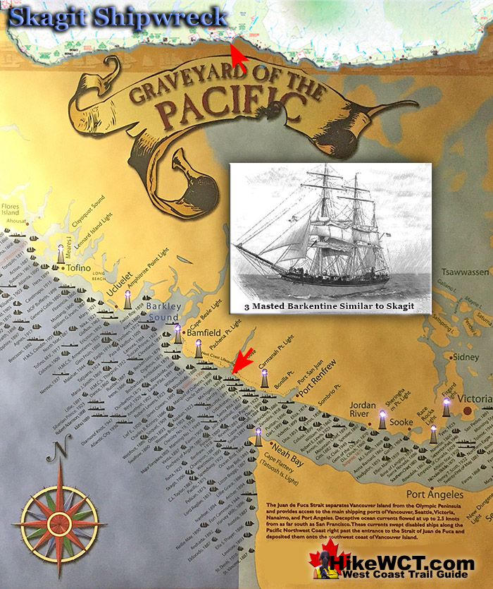
![]() The Skagit, a 3 masted barkentine of 506 tons was wrecked on the reef in front of Clo-oose on what is now the West Coast Trail. This 156 foot ship was built in Port Ludlow, Washington in 1883 and was primarily used to ship lumber down the coast to San Francisco. The Skagit was sailing in from San Francisco in ballast to Port Gamble, Washington to load lumber.
The Skagit, a 3 masted barkentine of 506 tons was wrecked on the reef in front of Clo-oose on what is now the West Coast Trail. This 156 foot ship was built in Port Ludlow, Washington in 1883 and was primarily used to ship lumber down the coast to San Francisco. The Skagit was sailing in from San Francisco in ballast to Port Gamble, Washington to load lumber.
 Alaskan Shipwreck at 4km
- Soquel Shipwreck at 5km
- Sarah Shipwreck at 7km
- Becherdass-Ambiadass Shipwreck at 8km
- Michigan Shipwreck at 12km
- Uzbekistan Shipwreck at 13.8km
- Varsity Shipwreck at 17.6km
- Valencia Shipwreck at 18.3km
- Janet Cowan Shipwreck at 19km
- Robert Lewers Shipwreck at 20km
- Woodside Shipwreck at 20.2km
- Uncle John Shipwreck at 26.2km
- Vesta Shipwreck at 29km
- Raita Shipwreck at 33km
- Skagit Shipwreck at 34.2km
- Santa Rita Shipwreck at 37km
- Dare Shipwreck at 39km
- Lizzie Marshall Shipwreck at 47km
- Puritan Shipwreck at 48.5km
- Wempe Brothers Shipwreck at 49.4km
- Duchess of Argyle Shipwreck at 58km
- John Marshall Shipwreck at 62.3km
- William Tell Shipwreck at 64.2km
- Revere Shipwreck at 69km
- Cyrus Shipwreck at 75km
The crew ran into a storm and massively misread her position. The crew sighted the light at Cape Flattery and believed it to be the light from the Umatilla lighthouse. The storm drove her on to the reef at 4am on October 25th, 1906. The impact of the ship hitting the rocks was so powerful that it killed the captain and cook. The remaining 8 crew members escaped by scrambling over the bow at daybreak and clawing their way to shore. They found help and shelter at Clo-oose and later brought down to Victoria. Today you will almost trip over one of the Skagit's anchors where it lays on the beach in the same spot as it has for a century. You will see it just past the Nitinaht Narrows ferry crossing, after you hike through the forest and emerge on the beach. The adventurous and determined may be able to find more remnants of the Skagit down at the foot of the reef, just below the low tide level.

More Shipwrecks Near the Skagit (KM34)
The Raita Shipwreck Near KM33
![]() There are a few shipwrecks fairly close to the Skagit shipwreck. The Raita shipwreck lays under the waves off Whyac Point, just a kilometre before the Skagit. The West Coast Trail is far inland on this section, however, so you will be passing the wreck site at quite a distance. The Raita was a French registered ship of of Papete, French Polynesia. She was loaded with lumber from Port Gamble, Washington heading to deliver it to Tahiti. Shortly after setting sail, she began taking on water. The strong winds and current overpowered the Raita and she was forced perilously close to Vancouver Island. In a desperate attempt to regain control, the crew began dumping their cargo into the sea and dropped her anchor. The winds picked up and snapped the anchor chain. The crew seeing the rocky shoreline coming near, launched a lifeboat and escaped. They managed to row safely to the Carmanah Point Lighthouse and were soon picked up by a passing CPR steamship. The Raita was bashed into the shore at Whyac Point, which at the time was known as Mission Point. At low tide she was high and dry on the rocks, completely out of the water. She was wrecked here on January 18th, 1925. Some of the old ship's hull timbers can still be seen today, a century later!
There are a few shipwrecks fairly close to the Skagit shipwreck. The Raita shipwreck lays under the waves off Whyac Point, just a kilometre before the Skagit. The West Coast Trail is far inland on this section, however, so you will be passing the wreck site at quite a distance. The Raita was a French registered ship of of Papete, French Polynesia. She was loaded with lumber from Port Gamble, Washington heading to deliver it to Tahiti. Shortly after setting sail, she began taking on water. The strong winds and current overpowered the Raita and she was forced perilously close to Vancouver Island. In a desperate attempt to regain control, the crew began dumping their cargo into the sea and dropped her anchor. The winds picked up and snapped the anchor chain. The crew seeing the rocky shoreline coming near, launched a lifeboat and escaped. They managed to row safely to the Carmanah Point Lighthouse and were soon picked up by a passing CPR steamship. The Raita was bashed into the shore at Whyac Point, which at the time was known as Mission Point. At low tide she was high and dry on the rocks, completely out of the water. She was wrecked here on January 18th, 1925. Some of the old ship's hull timbers can still be seen today, a century later!
Raita shipwreck continued here...
The Santa Rita Shipwreck Near KM37
![]() Past the Skagit you will come to the Santa Rita shipwreck. At about the 37 kilometre mark of the trail, look out to the ocean and you may spot a shallow reef that is a small island at low tide. This is where the Santa Rita, a steel steam ship collided with on an unlucky day in February, 1923. The Santa Rita was sailing in from San Pedro, California, in ballast for a port in the Puget Sound. In stormy weather and blindly navigating in poor visibility, the Carmanah Point Lighthouse was mistaken for the Cape Flattery Lighthouse on Tatoosh Island. The Carmanah Point Lighthouse is along the West Coast Trail and the Cape Flattery Lighthouse is 24.5 kilometres across Juan de Fuca Strait in the United States! The crew turned into what they thought was Juan de Fuca Strait and keeping the Cape Flattery Lighthouse on their right. Unfortunately they were about 20 kilometres north of what they thought, and were in fact keeping the Carmanah Point Lighthouse to their right and sailing directly at Vancouver Island. At 520am on February 15th, 1923 the Santa Rita collided head on into a small offshore reef just a few hundred metres from the West Coast Trail. The large ship, must have been sailing at quite a speed owing to the crew's reckoning that they were entering Juan de Fuca Strait. The sudden impact must have been horrific, loud, and completely unwarned. In the next few hours the entire crew of 30 escaped the wreck via breeches buoy. A breeches buoy is a rope based rescue system where a line runs from the ship to the shore and survivors ride in a flotation ring and leg harness.
Past the Skagit you will come to the Santa Rita shipwreck. At about the 37 kilometre mark of the trail, look out to the ocean and you may spot a shallow reef that is a small island at low tide. This is where the Santa Rita, a steel steam ship collided with on an unlucky day in February, 1923. The Santa Rita was sailing in from San Pedro, California, in ballast for a port in the Puget Sound. In stormy weather and blindly navigating in poor visibility, the Carmanah Point Lighthouse was mistaken for the Cape Flattery Lighthouse on Tatoosh Island. The Carmanah Point Lighthouse is along the West Coast Trail and the Cape Flattery Lighthouse is 24.5 kilometres across Juan de Fuca Strait in the United States! The crew turned into what they thought was Juan de Fuca Strait and keeping the Cape Flattery Lighthouse on their right. Unfortunately they were about 20 kilometres north of what they thought, and were in fact keeping the Carmanah Point Lighthouse to their right and sailing directly at Vancouver Island. At 520am on February 15th, 1923 the Santa Rita collided head on into a small offshore reef just a few hundred metres from the West Coast Trail. The large ship, must have been sailing at quite a speed owing to the crew's reckoning that they were entering Juan de Fuca Strait. The sudden impact must have been horrific, loud, and completely unwarned. In the next few hours the entire crew of 30 escaped the wreck via breeches buoy. A breeches buoy is a rope based rescue system where a line runs from the ship to the shore and survivors ride in a flotation ring and leg harness.
Santa Rita shipwreck continued here...
Campsites Near the Skagit (KM34)
Cribs Creek Campsite at 42km
![]() The Skagit shipwreck lays in a part of the West Coast Trail quite far from any campsites. The closest campsite is at Cribs Creek 8 kilometres further up the beach near kilometre 42. The Cribs Creek campsite is not terribly nice as the beach is a bit ugly, the creek is shallow and the campsite is always crowded as it is the only one for quite a distance. The beach from Cloo-oose is very nice and a much better option for camping, however signs indicate that camping is prohibited due to an abundance of wildlife in the area. The real reason is rumoured to be that the beach is in close proximity to the Clo-oose Indian Reserve. In the past the locals felt the West Coast Trail campers were trespassing on their beach. To mitigate any conflicts, an excuse was devised to discourage camping in the area. If this rumour is true, the plan has worked, however it has left a big chunk of the West Coast Trail with only one shabby, dedicated campsite.
The Skagit shipwreck lays in a part of the West Coast Trail quite far from any campsites. The closest campsite is at Cribs Creek 8 kilometres further up the beach near kilometre 42. The Cribs Creek campsite is not terribly nice as the beach is a bit ugly, the creek is shallow and the campsite is always crowded as it is the only one for quite a distance. The beach from Cloo-oose is very nice and a much better option for camping, however signs indicate that camping is prohibited due to an abundance of wildlife in the area. The real reason is rumoured to be that the beach is in close proximity to the Clo-oose Indian Reserve. In the past the locals felt the West Coast Trail campers were trespassing on their beach. To mitigate any conflicts, an excuse was devised to discourage camping in the area. If this rumour is true, the plan has worked, however it has left a big chunk of the West Coast Trail with only one shabby, dedicated campsite.
Cribs Creek Campsite is Awful and Crowded


Cribs Creek campsite continued here...
Carmanah Creek Campsite at 46km
![]() Carmanah Creek slowly flows through this wonderfully massive channel that cuts deep into the sand out to the ocean. There is a cable car crossing that connects to the forest on either side of the creek. Most West Coast Trail hikers pass the campsite here without taking a moment to look at the nice beach. Plenty of room for plenty of tents on the wide, sand beach. This is one of the beaches that makes you drop your pack, sit on the warm sand and gaze out at the ocean dumbfounded for minutes at a time. The West Coast Trail is something special! There is no shortage of great spots on the beach to put up your tent. You can even put up your tent along the river on the lovely sandy/rocky bank. Everybody camps at the unimpressive Cribs Creek campsite just 4 kilometres away, leaving Carmanah Creek a serene little hideaway. This is one of the campsites where you will want to stay for days, so you might want to include that in your itinerary! There are the usual West Coast Trail campsite amenities at Carmanah Creek, including some clearings in the forest for tents. The beach is ideal for camping, and on a sunny day, you will find yourself wandering down the lovely beach towards the Carmanah Lighthouse. Chez Monique's is along the beach between the lighthouse and Carmanah Creek. There you will find a restaurant along the beach with burgers and drinks. Seems a bit strange to encounter a restaurant in the middle of the West Coast Trail, but it has been here for years and will likely remain. For some, Chez Monique's is a highlight of the trail, for others it is an annoying bit of civilisation in the midst of the wild beauty of the west coast of Vancouver Island.
Carmanah Creek slowly flows through this wonderfully massive channel that cuts deep into the sand out to the ocean. There is a cable car crossing that connects to the forest on either side of the creek. Most West Coast Trail hikers pass the campsite here without taking a moment to look at the nice beach. Plenty of room for plenty of tents on the wide, sand beach. This is one of the beaches that makes you drop your pack, sit on the warm sand and gaze out at the ocean dumbfounded for minutes at a time. The West Coast Trail is something special! There is no shortage of great spots on the beach to put up your tent. You can even put up your tent along the river on the lovely sandy/rocky bank. Everybody camps at the unimpressive Cribs Creek campsite just 4 kilometres away, leaving Carmanah Creek a serene little hideaway. This is one of the campsites where you will want to stay for days, so you might want to include that in your itinerary! There are the usual West Coast Trail campsite amenities at Carmanah Creek, including some clearings in the forest for tents. The beach is ideal for camping, and on a sunny day, you will find yourself wandering down the lovely beach towards the Carmanah Lighthouse. Chez Monique's is along the beach between the lighthouse and Carmanah Creek. There you will find a restaurant along the beach with burgers and drinks. Seems a bit strange to encounter a restaurant in the middle of the West Coast Trail, but it has been here for years and will likely remain. For some, Chez Monique's is a highlight of the trail, for others it is an annoying bit of civilisation in the midst of the wild beauty of the west coast of Vancouver Island.
The Carmanah Creek Campsite is Gorgeous


Carmanah Creek campsite continued here...
Bonilla Creek Campsite at 48km
![]() To the north you will find two excellent campsites, Klanawa River and Tsusiat Falls. The campsite at Klanawa River is quite nice because of its lovely, swimmable river, expansive beach and serenity relative to other West Coast Trail campsites.. Though the beach is a thick, tangle of driftwood, you can still manage to find cleared areas perfect for a tent. Klanawa River is just a couple kilometres from Tsusiat Falls. Tsusiat Falls is pretty impressive and hardly any West Coast Trail hikers don't camp there. This leaves few people at Klanawa River. Beautiful beach and a wonderfully huge river, the Klanawa River campground is fantastic. And because it is close to the super popular Tsusiat Falls campground it is often quiet and serene. Also, the main trail runs to the cable car crossing which diverts the crowds away. At Klanawa River you will find the water flowing past wide and slow. The river is deep enough to dive into from the riverbank. Which is the best way to get in as it is always surprisingly cold. There are several nice places in the morass of tangled driftwood logs to put up a tent. This gives you a nice feeling of having partial walls and you are never more than a metre away from a log to sit on. In the forest you will find a few more, very nice and also serene feeling clearings for tents. Always with a perfect little fire ring in the centre and sometimes with log furniture surrounding. It is hard to say where is better for your tent, in the wild, deep forest or the wild, driftwood scattered beach. The forest is a bit more cozy feeling and especially suited for a campfire in the forest. The beach, however has the benefit of a perfectly smooth, sand surface under your tent and the ever present river and ocean view. You have the same amenities at Klanawa River as you do at most other West Coast Trail campsites. Outhouses and animal proof food boxes. The water from Klanawa River is nice, clean and just steps away. Beware of skinny dipping in the river, the trail runs on the opposite side of the river behind a narrow band of trees! Possibly the most endearing feature of the campsite at Klanawa River is how beautifully quiet it is. Nobody camps here and everyone camps at the nearby Tsusiat Falls. Almost every hiker passes by without even a look at the beach. Camping here one night is recommended before or after a night at Tsusiat Falls.
To the north you will find two excellent campsites, Klanawa River and Tsusiat Falls. The campsite at Klanawa River is quite nice because of its lovely, swimmable river, expansive beach and serenity relative to other West Coast Trail campsites.. Though the beach is a thick, tangle of driftwood, you can still manage to find cleared areas perfect for a tent. Klanawa River is just a couple kilometres from Tsusiat Falls. Tsusiat Falls is pretty impressive and hardly any West Coast Trail hikers don't camp there. This leaves few people at Klanawa River. Beautiful beach and a wonderfully huge river, the Klanawa River campground is fantastic. And because it is close to the super popular Tsusiat Falls campground it is often quiet and serene. Also, the main trail runs to the cable car crossing which diverts the crowds away. At Klanawa River you will find the water flowing past wide and slow. The river is deep enough to dive into from the riverbank. Which is the best way to get in as it is always surprisingly cold. There are several nice places in the morass of tangled driftwood logs to put up a tent. This gives you a nice feeling of having partial walls and you are never more than a metre away from a log to sit on. In the forest you will find a few more, very nice and also serene feeling clearings for tents. Always with a perfect little fire ring in the centre and sometimes with log furniture surrounding. It is hard to say where is better for your tent, in the wild, deep forest or the wild, driftwood scattered beach. The forest is a bit more cozy feeling and especially suited for a campfire in the forest. The beach, however has the benefit of a perfectly smooth, sand surface under your tent and the ever present river and ocean view. You have the same amenities at Klanawa River as you do at most other West Coast Trail campsites. Outhouses and animal proof food boxes. The water from Klanawa River is nice, clean and just steps away. Beware of skinny dipping in the river, the trail runs on the opposite side of the river behind a narrow band of trees! Possibly the most endearing feature of the campsite at Klanawa River is how beautifully quiet it is. Nobody camps here and everyone camps at the nearby Tsusiat Falls. Almost every hiker passes by without even a look at the beach. Camping here one night is recommended before or after a night at Tsusiat Falls.
Bonilla Creek Campsite is Amazing


Bonilla Creek campsite continued here...
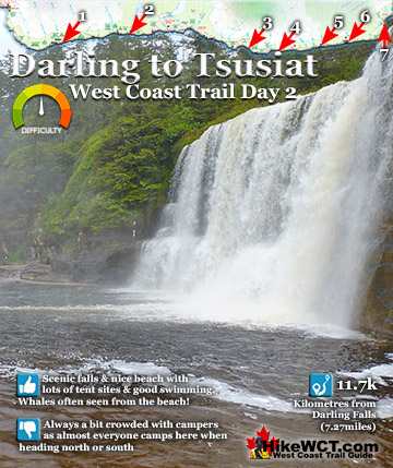
Tsusiat Falls Campsite at 25km
![]() One of the most popular and beautiful campsites along the West Coast Trail. Tsusiat Falls is one of the main highlights on the trail with its dramatically wide and beautifully picturesque appearance. You will find Tsusiat Falls at the base of an extraordinary array of ladders extending hundreds of metres up into the trees. Tsusiat Falls pours over an abrupt and wide cliff onto the sandy beach. The force of the water has dug out quite a large pool that flows in an ever changing channel through the sand to the ocean. It is quite common to see whales passing in the distance from the beach at Tsusiat. The beach is raised up a few metres from the ocean and affords you a better vantage point over the ocean than you get elsewhere. Tsusiat Falls campsite is wide and extends as far as you want to go down the beach. As everyone has seen pictures of it, everyone aims for it to spend the night. If you don't mind crowds then you'll love it. If you don't like crowds, you may have trouble finding a serene corner to camp. If you really want to find serenity, you might try camping at the far end of the beach where you will find quite a large sea cave. If you love waking up to whales in the distance and the beautiful roar of waterfalls nearby, then you will find that at Tsusiat. The campsite is well designed for crowds though as the hundreds of driftwood logs on the beach have fashioned partitioned areas randomly, where some sort of organized privacy exists.
One of the most popular and beautiful campsites along the West Coast Trail. Tsusiat Falls is one of the main highlights on the trail with its dramatically wide and beautifully picturesque appearance. You will find Tsusiat Falls at the base of an extraordinary array of ladders extending hundreds of metres up into the trees. Tsusiat Falls pours over an abrupt and wide cliff onto the sandy beach. The force of the water has dug out quite a large pool that flows in an ever changing channel through the sand to the ocean. It is quite common to see whales passing in the distance from the beach at Tsusiat. The beach is raised up a few metres from the ocean and affords you a better vantage point over the ocean than you get elsewhere. Tsusiat Falls campsite is wide and extends as far as you want to go down the beach. As everyone has seen pictures of it, everyone aims for it to spend the night. If you don't mind crowds then you'll love it. If you don't like crowds, you may have trouble finding a serene corner to camp. If you really want to find serenity, you might try camping at the far end of the beach where you will find quite a large sea cave. If you love waking up to whales in the distance and the beautiful roar of waterfalls nearby, then you will find that at Tsusiat. The campsite is well designed for crowds though as the hundreds of driftwood logs on the beach have fashioned partitioned areas randomly, where some sort of organized privacy exists.
Beautiful Tsusiat Falls


Tsusiat Falls campsite continued here...
West Coast Trail A to Z

The West Coast Trail by Day

Explore BC Hiking Destinations!
The West Coast Trail
Victoria Hiking Trails
Clayoquot Hiking Trails
Whistler Hiking Trails
Squamish Hiking Trails

Vancouver Hiking Trails