
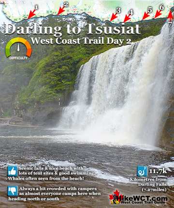
![]() The route from Darling River to Tsusiat Falls is just under 12 kilometres and quite a lot of that distance can be hiked on the beach. From Darling River you can take an inland route or walk along the beach. The beach route is very nice and few people hike the challenging inland route. Don't forget to jump in the pool at Darling Falls before you start hiking, you'll feel amazingly energized for the start of the trail!
The route from Darling River to Tsusiat Falls is just under 12 kilometres and quite a lot of that distance can be hiked on the beach. From Darling River you can take an inland route or walk along the beach. The beach route is very nice and few people hike the challenging inland route. Don't forget to jump in the pool at Darling Falls before you start hiking, you'll feel amazingly energized for the start of the trail!
 You can swim under two waterfalls on day 2
- Fairly relaxing hiking, much of it along the beach
- Interesting little sea cave at Orange Juice Creek
- Tsocowis Creek crossing has amazing views
- Lots of good water sources along the route
- The infamous Valencia Bluffs at 18k
- The Woodside's anchor on the rocks near 20k
- First cable car river crossing over Klanawa River
- Tsusiat Falls campsite is great for whale watching
 The beaches aren't the best looking on the WCT
Hike the West Coast Trail
![]() Prologue
Prologue ![]() 1: The West Coast Trail
1: The West Coast Trail ![]() 2: When to Hike & Fees
2: When to Hike & Fees ![]() 3: Trailheads
3: Trailheads ![]() 4: Getting There
4: Getting There ![]() 5: Considerations
5: Considerations ![]() 6: Campsites
6: Campsites ![]() 7: Shipwrecks
7: Shipwrecks ![]() 8: Routes
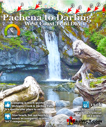
8: Routes ![]() Day 1 Pachena to Darling
Day 1 Pachena to Darling ![]() Day 2 Darling to Tsusiat
Day 2 Darling to Tsusiat ![]() Day 3 Tsusiat to Carmanah
Day 3 Tsusiat to Carmanah ![]() Day 4 Carmanah to Walbran
Day 4 Carmanah to Walbran ![]() Day 5 Walbran to Cullite
Day 5 Walbran to Cullite ![]() Day 6 Cullite to Camper
Day 6 Cullite to Camper ![]() Day 7 Camper to Thrasher
Day 7 Camper to Thrasher ![]() Michigan Creek at 12k
Michigan Creek at 12k ![]() Darling River at 14k
Darling River at 14k ![]() Orange Juice Creek at 15k
Orange Juice Creek at 15k ![]() Tsocowis Creek at 16.5k
Tsocowis Creek at 16.5k ![]() Klanawa River at 23k
Klanawa River at 23k ![]() Tsusiat Falls at 25k
Tsusiat Falls at 25k ![]() Cribs Creek at 42k
Cribs Creek at 42k ![]() Carmanah Creek at 46k
Carmanah Creek at 46k ![]() Bonilla Creek at 48k
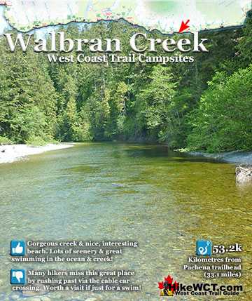
Bonilla Creek at 48k ![]() Walbran Creek at 53k
Walbran Creek at 53k ![]() Cullite Cove at 58k
Cullite Cove at 58k ![]() Camper Bay at 62k
Camper Bay at 62k ![]() Thrasher Cove at 70k
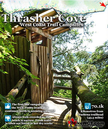
Thrasher Cove at 70k
When you get to Tsusiat Falls you can jump in there too. To start and end your hike by swimming under waterfalls on the West Coast Trail makes for a pretty memorable day! There is quite a lot of interesting sights on this section. You can touch a big wall of rusting metal from an unidentified shipwreck near Tsocowis Creek at 16km. At 18km you will have a magnificent view from the top of Valencia Bluffs. This is of course where the famous Valencia disaster occurred and was the final impetus to create a the West Coast Trail. You can look down on the swirling torrents of white water crashing onto the unforgiving, rocky shore below. Further along the trail, just past the 20 kilometre mark you will nearly trip over the huge anchor on the rocks. This, we can be fairly sure came from the Woodside, a ship that provided a regular ferry service up and down the coast of Vancouver Island. At 23km you come to the mighty Klanawa River and your first cable car crossing on the West Coast Trail. After Klanawa River you just have a couple kilometres of hiking through the forest before descending the astonishingly tall network of ladders down to Tsusiat Falls.

Day 2: Darling River to Tsusiat Falls on the West Coast Trail
The Darling River campsite is nice, despite the beach being not terribly pretty, at least compared to the strikingly varied beach campsites to come further along the trail. Beautiful Darling Falls more than makes up for the mediocre beach.

Perfect Darling Falls
The perfect little waterfall pouring into the green pool of water contrasts nicely with the meandering river that is strewn with a surreal collection of huge driftwood deadfall thrown in by winter storms. With the river at just half a metre deep, the clear green water pours around a tangle of ocean polished giants with bark long gone leaving smooth, angular surfaces polished dinosaur bone smooth.

Darling River Storms
You wonder what kind of crazy storm could launch a huge centuries old cedar so far up the river and leave it lodged in the middle of the river with its worn away, but still huge roots sunk a metre into the river bed. You can assume that by the rest of its trunk jutting a metre out of the water. Does next year’s storms rip this giant out and carry it back out to sea and replace it with new giants? That seems to be the case as every year the brontosaurus sized collection of deadfall is exchanged with another.

Leaving Darling River Camp 14km
![]() The beach extending south from Darling River is similarly smashed in by winter storms and driftwood logs pile up near the treeline. Over the hiking season campers arrange the tangled mess into some interesting structures. During days of nice weather, stretching out your camp on the smooth sand in the open is nice, but during days of rain, sheltering close to the edge of the forest gives you at least a feeling of shelter. There are always odd collections of driftwood structures to nestle your tent close to and string up a tarp to. Mostly to keep the rain off, but camping amongst driftwood has a certain West Coast Trail charm to it.
The beach extending south from Darling River is similarly smashed in by winter storms and driftwood logs pile up near the treeline. Over the hiking season campers arrange the tangled mess into some interesting structures. During days of nice weather, stretching out your camp on the smooth sand in the open is nice, but during days of rain, sheltering close to the edge of the forest gives you at least a feeling of shelter. There are always odd collections of driftwood structures to nestle your tent close to and string up a tarp to. Mostly to keep the rain off, but camping amongst driftwood has a certain West Coast Trail charm to it.

You feel like a kid again, building a beach fort. Even on a rainy day the view through every gap in your fort is sensational. More than a century ago there was an actual cabin built by lineman David Logan next to Darling River. He built it out of driftwood and it was used as a survival shelter for many years.
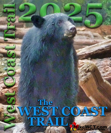
Darling West Coast Trail Black Bears
Darling River in recent years has had more than its share of bear sightings. This big black bear was very busy digging in the rocks and driftwood next to Darling River one spring morning. Very busy digging, but stared us down from quite a distance away with a menacing look and visible claws at the end of very long legs. So much for a morning dip into Darling River under the falls.

In other parts of BC you lose any fear you might have of black bears with their skittish and fleeing nature, but West Coast Trail bears seem altogether different. This was his beach and he wasn’t going anywhere and definitely wasn’t going to let anyone pass.

Far away, out of focus and in pouring rain, he kept staring us down.
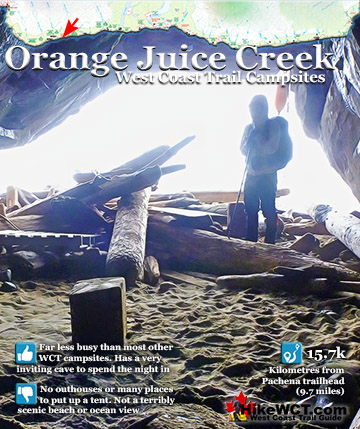
Orange Juice Cave
Leaving the Darling River campsite heading south you come to another West Coast Trail campsite remarkably different than the previous two, the Orange Juice Creek campsite. As you approach you hear the crashing sound of a waterfall. Before you can see the source, you notice a big cave carved out of the cliff along the beach. It isn’t a big, cavernous cave, but the result of centuries of waves carving out a room of sorts into the base of the cliff.

The unassuming opening of the cave conceals the roominess of the interior. Driftwood logs arranged in a circle around a small fire ring hints at the popularity of this little hideaway from the elements. Looking at the walls there is an unexpectedly old collection of graffiti carved and written on the walls, some dating back over five decades!

Orange Juice Creek Campsite at 15km
![]() Back outside the cave the loud crashing of water gets louder as you approach a hilariously huge tangle of driftwood logs. Piled up so high that you can hardly see the small waterfall crashing down into a reddish brown pool of water at the edge of a steep cliff. This is the aptly named Orange Juice Creek which gets its strange colour from tannins leached out of the rainforest by water. Though the colour is not appetizing, it is perfectly good to drink, though like all the creeks and rivers on the West Coast Trail it is advised to treat, filter or boil it first to avoid beaver fever.
Back outside the cave the loud crashing of water gets louder as you approach a hilariously huge tangle of driftwood logs. Piled up so high that you can hardly see the small waterfall crashing down into a reddish brown pool of water at the edge of a steep cliff. This is the aptly named Orange Juice Creek which gets its strange colour from tannins leached out of the rainforest by water. Though the colour is not appetizing, it is perfectly good to drink, though like all the creeks and rivers on the West Coast Trail it is advised to treat, filter or boil it first to avoid beaver fever.


Orange Juice Campsite is Underrated
The Orange Juice Creek campsite suffers from a bad first impression as on first glance it appears as a messy pile of driftwood with a horribly coloured creek flowing out of it. If you give it a moment or two, you come to appreciate its rustic, West Coast Trail charm. The absurdly huge pile of driftwood logs is interesting in its own right and after long day of hiking, the small pool under the falls is great to jump into. Also, the cave is weirdly cozy and at night with a little campfire it surely would be an amazing place to be and surely a unique experience for most. Added to that, the poor first impressing the campsite has means that very few hikers stop to camp and you might have this wildly interesting place to yourself.

Orange Juice Creek Driftwood Crossing
Crossing Orange Juice Creek is interesting in that you have to cross the erratic collection of logs to get to the other side. You could walk through the shallow, ankle deep creek as it fans out into the ocean, but it’s not nearly as fun as scrambling over the giant barricade of logs. Once across the sandy beach broadens and gets increasingly pretty with smooth sand meeting the ocean and stretching far off in the distance.

Tsocowis Shipwreck
![]() After only one kilometre of increasingly scenic beach walking you suddenly come to a mangled, old shipwreck high up on the beach. Strangely, this one seems to be unidentified on the West Coast Trail map. Which is only strange until you start to fathom the crazy number of shipwrecks along this coast over the past couple centuries. So many ships wrecked along this Graveyard of the Pacific that after a few particularly big winter storms a century ago, lost ships would be searched for only to find additional ships that were not yet reported lost! This one might be one of those unidentified ones, or maybe I haven’t asked the right person or read the right West Coast Trail shipwreck book to find it.
After only one kilometre of increasingly scenic beach walking you suddenly come to a mangled, old shipwreck high up on the beach. Strangely, this one seems to be unidentified on the West Coast Trail map. Which is only strange until you start to fathom the crazy number of shipwrecks along this coast over the past couple centuries. So many ships wrecked along this Graveyard of the Pacific that after a few particularly big winter storms a century ago, lost ships would be searched for only to find additional ships that were not yet reported lost! This one might be one of those unidentified ones, or maybe I haven’t asked the right person or read the right West Coast Trail shipwreck book to find it.

Tsocowis Ranger Cabin
![]() Just beyond the shipwreck you see a very unusual thing, unusual for the West Coast Trail anyway, a little cabin. It is the Tsocowis ranger cabin and it turns out that some form of emergency shelter has been here for over a century. Used by park staff these days, but in the past it would have been used as an emergency shelter for shipwreck survivors. They used to be stocked with food and with a fireplace to keep warm, a simple structure like this surely saved quite a few shipwreck survivors in the past.
Just beyond the shipwreck you see a very unusual thing, unusual for the West Coast Trail anyway, a little cabin. It is the Tsocowis ranger cabin and it turns out that some form of emergency shelter has been here for over a century. Used by park staff these days, but in the past it would have been used as an emergency shelter for shipwreck survivors. They used to be stocked with food and with a fireplace to keep warm, a simple structure like this surely saved quite a few shipwreck survivors in the past.

Tsocowis Creek Campsite at 16.5km
![]() Continuing along the beach past the ranger cabin you start to hear another crashing waterfall. Similar in size to Orange Juice Falls, Tsocowis Falls crash violently into a pool surrounded by big driftwood logs. The pool here is much bigger than at Orange Juice Creek and there are far less driftwood logs. Also, Tsocowis Creek cuts a deep channel through the beach to the ocean. Much like at Orange Juice Creek, the Tsocowis Creek campsite looks a bit messy on first glance and comparatively few hikers camp here either. I has more campsite amenities than Orange Juice, with Tsocowis having outhouses and food cache boxes.
Continuing along the beach past the ranger cabin you start to hear another crashing waterfall. Similar in size to Orange Juice Falls, Tsocowis Falls crash violently into a pool surrounded by big driftwood logs. The pool here is much bigger than at Orange Juice Creek and there are far less driftwood logs. Also, Tsocowis Creek cuts a deep channel through the beach to the ocean. Much like at Orange Juice Creek, the Tsocowis Creek campsite looks a bit messy on first glance and comparatively few hikers camp here either. I has more campsite amenities than Orange Juice, with Tsocowis having outhouses and food cache boxes.


Serenity at Tsocowis Creek
The Tsocowis Creek campsite is actually not that bad. The sand is nice along the beach, the view from the bridge above the falls is fantastic. As with the campsite at Orange Juice Creek, Tsocowis is usually overlooked by hikers. If serenity is what you are after, you will probably get it here.

Should You Camp at Tsocowis Creek?
Yes, if you love a peaceful campsite that you may have to yourself. If that is not a big consideration than you should probably move on to Darling River just three kilometres away heading north, or Klanawa River, five kilometres heading south.

Tsocowis Creek Bridge
Wonderfully steep and long ladders take you high up into the forest alongside Tsocowis Creek which crashes down a steep set of cliffs nearby. The ladders lead to a narrow bridge that crosses over the creek and gives you a fantastic view from above the falls smashing onto the beach far below. In the opposite direction you can see Tsocowis Creek flow through narrow channels carved out of the cliff disappearing up into the forest.


More West Coast Trail Ladders
After a few kilometres of relaxing and flat beach hiking, the forest is quite a shock with its tall ladders up and tall ladders down. The ladders on the West Coast Trail are definitely one of its defining features and though they are absurdly tall, they are always fun.

West Coast Trail Mud
Another defining feature of the West Coast Trail that is not as fun as the ladders is the sections of mud. Sections of trail with unavoidable pools of mud that are often knee deep and appear at an ever increasing rate along this section of the trail.

The Varsity Shipwreck at 17.6km
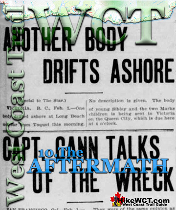
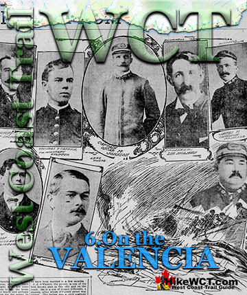
![]() In 1940 three survivors of the Varsity shipwreck swam and crawled their way to the shelf below what is now called Valencia Bluffs. They now found themselves up against a tall, steep cliff that they had no hope of climbing. Out of the wreckage of the Varsity they were able to keep from dying of exposure and also construct a ladder up the cliff and found the trail that would one day be called the West Coast Trail. The three survivors made their way to Tsocowis Creek and found the Tsocowis cabin occupied by a lineman who was able to call for a rescue. Today the Varsity’s huge metal winch can still sometimes be seen rusting in a crevice at the foot of Valencia Bluffs. From Tsocowis Creek, Valencia Bluffs is about 1 kilometre further along the trail. It is a gorgeous viewpoint high up on the cliffs overlooking the wreck site of the Varsity as well as the most notoriously tragic shipwreck of the entire Graveyard of the Pacific. The Valencia wrecked here just 25 metres from the cliffs, but the freezing cold and stormy seas nearly killed all the 170 passengers and crew. Over the next 36 hours the ship was battered by waves as the survivors clung to parts of the ship not submerged. Lifeboats packed with woman and children were lowered into the churning sea only to be flipped over or smashed into the side of the Valencia. Their occupants instantly disappearing under the crashing waves. Over the 36 hour ordeal, 133 would die and only 37 survive. Most of the dead were never found and the Valencia shipwreck is often regarded as the worst maritime disaster in the Graveyard of the Pacific. Though the number of deaths is second to the sinking of the Pacific, that tragedy was mercifully quicker.
In 1940 three survivors of the Varsity shipwreck swam and crawled their way to the shelf below what is now called Valencia Bluffs. They now found themselves up against a tall, steep cliff that they had no hope of climbing. Out of the wreckage of the Varsity they were able to keep from dying of exposure and also construct a ladder up the cliff and found the trail that would one day be called the West Coast Trail. The three survivors made their way to Tsocowis Creek and found the Tsocowis cabin occupied by a lineman who was able to call for a rescue. Today the Varsity’s huge metal winch can still sometimes be seen rusting in a crevice at the foot of Valencia Bluffs. From Tsocowis Creek, Valencia Bluffs is about 1 kilometre further along the trail. It is a gorgeous viewpoint high up on the cliffs overlooking the wreck site of the Varsity as well as the most notoriously tragic shipwreck of the entire Graveyard of the Pacific. The Valencia wrecked here just 25 metres from the cliffs, but the freezing cold and stormy seas nearly killed all the 170 passengers and crew. Over the next 36 hours the ship was battered by waves as the survivors clung to parts of the ship not submerged. Lifeboats packed with woman and children were lowered into the churning sea only to be flipped over or smashed into the side of the Valencia. Their occupants instantly disappearing under the crashing waves. Over the 36 hour ordeal, 133 would die and only 37 survive. Most of the dead were never found and the Valencia shipwreck is often regarded as the worst maritime disaster in the Graveyard of the Pacific. Though the number of deaths is second to the sinking of the Pacific, that tragedy was mercifully quicker.

West Coast Trail Storm Damage
Passing through a few pools of mud along the trail you come to yet another charming quirk of the West Coast Trail, boardwalk sections smashed by deadfall. Every year hundreds of enormous trees crash down across the trail and sometimes they crush sections of carefully constructed boardwalk. The devastation is quite a sight to see and like an exhibit of West Coast Trail art, many are left partly destroyed and mangled. Which is kind of nice as they are a stark reminder of the brutality of the coastline you are hiking and definitely makes the trail more of an adventure.

The swampy, muddy nature of the rainforest along the cliffs high above the ocean here has meant a lot of boardwalk was built along the trail here. Many decades of wear and tear and forest growth has given them a hardy, antique feel. Weather beaten and with the forest growing out of every crack and gap.
Valencia Bluffs and Valencia Shipwreck at 18.2km
![]() The Valencia is usually regarded as the worst shipwreck disaster in the Graveyard of the Pacific and the final impetus for the creation of the West Coast Trail. The SS Valencia was an iron-hulled, 1600 ton passenger steamer built in 1882. Originally built for service between Venezuela and New York City, she later became a coastal passenger liner on the West Coast of the United States. In 1906 she was wrecked off Cape Beale, near Clo-oose, on the west coast of Vancouver Island. The captain did not take into account the strong northerly current that caused ships to overrun the Juan de Fuca Strait by a considerable distance. Blinded by the weather and battered with strong winds and currents, the captain turned the Valencia toward the coast for its run into the strait. Just before midnight on the 22nd of January, she collided with the reef near Pachena Point on the southwest coast of Vancouver Island. The number of fatalities is thought to be 133, with only 37 survivors. The Canadian government rapidly began work on what would result in the West Coast Trail. A lighthouse was was constructed and regularly spaced shelters along the newly constructed trail. The Valencia shipwreck disaster happened in 1906, the Pachena Point Lighthouse was finished in 1908, and in 1911 the West Coast Trail was completed.
The Valencia is usually regarded as the worst shipwreck disaster in the Graveyard of the Pacific and the final impetus for the creation of the West Coast Trail. The SS Valencia was an iron-hulled, 1600 ton passenger steamer built in 1882. Originally built for service between Venezuela and New York City, she later became a coastal passenger liner on the West Coast of the United States. In 1906 she was wrecked off Cape Beale, near Clo-oose, on the west coast of Vancouver Island. The captain did not take into account the strong northerly current that caused ships to overrun the Juan de Fuca Strait by a considerable distance. Blinded by the weather and battered with strong winds and currents, the captain turned the Valencia toward the coast for its run into the strait. Just before midnight on the 22nd of January, she collided with the reef near Pachena Point on the southwest coast of Vancouver Island. The number of fatalities is thought to be 133, with only 37 survivors. The Canadian government rapidly began work on what would result in the West Coast Trail. A lighthouse was was constructed and regularly spaced shelters along the newly constructed trail. The Valencia shipwreck disaster happened in 1906, the Pachena Point Lighthouse was finished in 1908, and in 1911 the West Coast Trail was completed.

SS Valencia: The Ghost Ship that Haunts the Graveyard of the Pacific
This is a good documentary of the Valencia from the Youtube channel Big Old Boats. The events are narrated over photos and videos similar to what the Valencia faced. Though the photos and videos are mostly quite different, they still give a sense of how things actually were. For example, the coastline videos appear to be the Oregon coast, not the West Coast of Vancouver Island. An excellent video and retelling of this incredible story.
Janet Cowan Shipwreck at 19k
![]() The Janet Cowan was a steel sailing vessel, four-masted, bark rigged, of 2498 tons built at Glasgow in 1889. She was wrecked at about the 19 kilometre mark on the West Coast Trail with several lives lost. The Janet Cowan shipwreck shone a light on the necessity of building more lighthouses and constructing a coastal lifesaving trail. Little was done, however, and just 10 years later, and less than a kilometre away, the Valencia met a similar fate. Considerably more loss of life and media attention spurred the Canadian government forward and the West Coast Trail and the nearby Pachena Point Lighthouse were born. The Janet Cowan was named after the maiden name of the wife of the first owner. Unlike most other shipwrecks in the Graveyard of the Pacific, a good record of the ship as well as at least a couple photographs of her still exist. The Janet Cowan sailed from Cape Town on September 11th, 1895, bound for Royal Roads(near Victoria) on Vancouver Island. With 1100 tons of ballast and a crew of 29. The long voyage went very well until the evening of December 30th, 1895. Approaching Juan de Fuca Strait, under easy sail and with moderate weather, attempts were made to signal for a tug or pilot. They received no response. With daylight gone, she was sailing blind into the Graveyard of the Pacific. The captain decided to wait for daylight before sailing further. Just after 7pm the wind shifted suddenly and steadily increased into a gale. The Janet Cowan was brought around and attempted to run out for an offing to wait out the storm. At 845pm, Cape Flattery Lighthouse was spotted four or five miles away. The weather continued to worsen, with a violent gale blowing, heavy seas and thick snow falling, the Captain worried that their repeated wearing(a sailing technique of turning through the wind to shift the wind from one side of the boat to the other), would cause them to lose ground. This agonizing battle went on in brutal darkness as they charted their position based on their last sight of Cape Flattery and estimated speed. They pinpointed their position to be about seven miles off Vancouver Island, with the time now being well after midnight. Just before 1am, the second mate reported land on the starboard bow. The crew rushed to steer away, however the ship was caught in the trough of the sea and still inching towards the shore. At 130am the Janet Cowan was perilously inside the outside breakers and unable to escape. The ship was swung broadside on, with her head to the westward and the seas breaking over her fore and aft, she crashed into the shore. The captain ordered all hands aft and one of the crew, Thomas Chamberlain volunteered to swim ashore with a rope. The attempt failed when the rope became hopelessly tangled in the rocks. He had to let it go to save himself, clawing his way to the shore. They succeeded on their next attempt, though with tremendous difficulty, by using a lifeboat to get to the shore with a rope. Bitterly cold weather, tumultuous, swirling seas, and overall precarious situation made the lifeboat unusable in getting the crew to the shore. Instead they used the line suspended between the shore and the ship to clumsily bring people over one at a time. In the frantic chaos of that night three of the crew drowned, never to be seen again. It is assumed they drowned while attempting the crossing, however, they were only noticed missing after a muster of the crew by the captain on shore. One final crewman, too afraid to leave the crumbling ship, remained. He eventually made it to shore after daybreak. Cold, wet and desperate, it was decided to make an attempt to reach Cape Beale Lighthouse and obtain assistance. With this object in view, the crew divided, and the telegraph line being found, it was decided to follow it, the younger members of the crew pushing ahead, and others following as best they could. The captain, who appears to have been worn out from incessant watching before reaching shore, being unable to keep up, the chief officer telling the steward and donkeyman to stay by and assist captain, pushed on himself in the hope of obtaining help. After spending a night in the woods, and finding it impossible to make progress through the heavy snow and dense forests, had no alternative but to return to wreck. On the way back he passed the body of captain. who had died from exposure, also bodies of W. Selkirk, donkeyman, and Peberval, A.B., and other members of the crew; reported death of George Kinnear, cook, from same cause. The wreck being reached, and sea having moderated, crew were enabled to get on board ship, and proceeded to land provisions and sails for making tents, and then made camp on beach, meanwhile, doing all they could to attract attention of passing vessels. Almost two weeks passed and on the 11th day of January, the steam-tug "Tyee" arrived on the scene and rescued mate and 12 of crew who were in the immediate vicinity of wreck. Leaving nine men in camp higher up on beach, who at the time could not be reached, and after an unsuccessful attempt at reaching them, owing to bad surf and darkness, the tug proceeded to Port Townsend. The nine men were rescued by Canadian steamer Princess Louise on Monday following, and safely landed at Victoria, B.C.
The Janet Cowan was a steel sailing vessel, four-masted, bark rigged, of 2498 tons built at Glasgow in 1889. She was wrecked at about the 19 kilometre mark on the West Coast Trail with several lives lost. The Janet Cowan shipwreck shone a light on the necessity of building more lighthouses and constructing a coastal lifesaving trail. Little was done, however, and just 10 years later, and less than a kilometre away, the Valencia met a similar fate. Considerably more loss of life and media attention spurred the Canadian government forward and the West Coast Trail and the nearby Pachena Point Lighthouse were born. The Janet Cowan was named after the maiden name of the wife of the first owner. Unlike most other shipwrecks in the Graveyard of the Pacific, a good record of the ship as well as at least a couple photographs of her still exist. The Janet Cowan sailed from Cape Town on September 11th, 1895, bound for Royal Roads(near Victoria) on Vancouver Island. With 1100 tons of ballast and a crew of 29. The long voyage went very well until the evening of December 30th, 1895. Approaching Juan de Fuca Strait, under easy sail and with moderate weather, attempts were made to signal for a tug or pilot. They received no response. With daylight gone, she was sailing blind into the Graveyard of the Pacific. The captain decided to wait for daylight before sailing further. Just after 7pm the wind shifted suddenly and steadily increased into a gale. The Janet Cowan was brought around and attempted to run out for an offing to wait out the storm. At 845pm, Cape Flattery Lighthouse was spotted four or five miles away. The weather continued to worsen, with a violent gale blowing, heavy seas and thick snow falling, the Captain worried that their repeated wearing(a sailing technique of turning through the wind to shift the wind from one side of the boat to the other), would cause them to lose ground. This agonizing battle went on in brutal darkness as they charted their position based on their last sight of Cape Flattery and estimated speed. They pinpointed their position to be about seven miles off Vancouver Island, with the time now being well after midnight. Just before 1am, the second mate reported land on the starboard bow. The crew rushed to steer away, however the ship was caught in the trough of the sea and still inching towards the shore. At 130am the Janet Cowan was perilously inside the outside breakers and unable to escape. The ship was swung broadside on, with her head to the westward and the seas breaking over her fore and aft, she crashed into the shore. The captain ordered all hands aft and one of the crew, Thomas Chamberlain volunteered to swim ashore with a rope. The attempt failed when the rope became hopelessly tangled in the rocks. He had to let it go to save himself, clawing his way to the shore. They succeeded on their next attempt, though with tremendous difficulty, by using a lifeboat to get to the shore with a rope. Bitterly cold weather, tumultuous, swirling seas, and overall precarious situation made the lifeboat unusable in getting the crew to the shore. Instead they used the line suspended between the shore and the ship to clumsily bring people over one at a time. In the frantic chaos of that night three of the crew drowned, never to be seen again. It is assumed they drowned while attempting the crossing, however, they were only noticed missing after a muster of the crew by the captain on shore. One final crewman, too afraid to leave the crumbling ship, remained. He eventually made it to shore after daybreak. Cold, wet and desperate, it was decided to make an attempt to reach Cape Beale Lighthouse and obtain assistance. With this object in view, the crew divided, and the telegraph line being found, it was decided to follow it, the younger members of the crew pushing ahead, and others following as best they could. The captain, who appears to have been worn out from incessant watching before reaching shore, being unable to keep up, the chief officer telling the steward and donkeyman to stay by and assist captain, pushed on himself in the hope of obtaining help. After spending a night in the woods, and finding it impossible to make progress through the heavy snow and dense forests, had no alternative but to return to wreck. On the way back he passed the body of captain. who had died from exposure, also bodies of W. Selkirk, donkeyman, and Peberval, A.B., and other members of the crew; reported death of George Kinnear, cook, from same cause. The wreck being reached, and sea having moderated, crew were enabled to get on board ship, and proceeded to land provisions and sails for making tents, and then made camp on beach, meanwhile, doing all they could to attract attention of passing vessels. Almost two weeks passed and on the 11th day of January, the steam-tug "Tyee" arrived on the scene and rescued mate and 12 of crew who were in the immediate vicinity of wreck. Leaving nine men in camp higher up on beach, who at the time could not be reached, and after an unsuccessful attempt at reaching them, owing to bad surf and darkness, the tug proceeded to Port Townsend. The nine men were rescued by Canadian steamer Princess Louise on Monday following, and safely landed at Victoria, B.C.
Derelict Grader and Donkey Engine at 19km
About one kilometre past Valencia Bluffs you will encounter two relics of the past. A derelict grader and a donkey engine. A donkey engine is the common name for a steam powered winch or logging engine. Cutting down a tree a century ago was hard enough, but you also have to pull it out of the forest to be transported. Their operation was quite simple. A line horse would carry the cable out to the felled tree, tie it around and the donkey engine would drag the log toward it. Invented in 1882, the donkey engine was the workhorse in the forest industry until the invention of the internal combustion engine and the diesel powered tractor crawler. Donkey engines suddenly became obsolete and now reside in museums and many more sit abandoned in forests. The West Coast Trail has two of these ancient donkey engines. There is another one near the end of the trail at kilometre 72, 3 kilometres from the Gordon River trailhead.

More West Coast Trail Mud
More destroyed boardwalk and mud on the West Coast Trail. With the seemingly endless rainfall along the trail it is no wonder many sections are barely intact. There are dozens of hilarious boardwalk sections like this one that abruptly end at a big pool of mud.

Ladder Down to Trestle Creek Beach
One of the remarkable sights on the West Coast Trail that you never get used to is the sudden appearance of a ladder or stairs. Having slogged through the wet, muddy, zigzagging rainforest trail for a long and exhausting time. Rarely able to see more than a few metres in any direction due to the wildly encroaching forest pushing through and over the trail. Suddenly you see a gap in the forest a few metres ahead and the trail appears to suddenly end. As you get closer you find yourself at one of many extraordinary locations on the West Coast Trail. Often you come to an alarmingly vertical ladder that descends down so far you can't see the bottom as it disappears in the rainforest far below. Other times, such as the one shown below you find an increasingly descending boardwalk arching down to yet another wild and beautiful beach. This little hidden beach is called Trestle Creek Beach.

Trestle Creek Beach View of Robert Lewers Shipwreck
![]() As you emerge from the forest and onto the rocky beach you will be about 300 metres from the shipwreck of Robert Lewers which rests under the waves. The Robert Lewers was a 185 foot, four masted schooner of 732 tons, built in Port Blakely, Washington in 1889. She was wrecked just before the kilometre 20 mark on the West Coast Trail, just half a kilometre from the Janet Cowen shipwreck, and less than two kilometres from the Valencia shipwreck. The Robert Lewers entered the Graveyard of the Pacific during the spring of 1923. The ship was heading for Bellingham, Washington in ballast from Honolulu with a crew of 14. The circumstances of how Robert Lewers became wrecked on this shore is a depressing tale of unfortunate mishaps. As she entered the Juan de Fuca Strait she found little wind and was forced to wait for a tug boat. A tug boat finally arrived to tow her into port. While passing the hawser line from the tug, it became tangled in the masts and rigging, tearing away the Robert Lewers jib boom and head gear. Another attempt was made with hopeful success, until the tow rope snapped. In the confusion, the tug hit a rock and was forced to limp back to Seattle for repairs. Through this ordeal the ship creeped perilously close to shore so the port anchor was released. Moments later the stern of the ship was dragging along the bottom. As the situation became desperate a call was sent out for another tug. An hour and a half passed, waiting for rescue as the ship continued to grind on the reef. When the second tug arrived, it could not get in close enough to attach a line. The wind was picking up so the captain decided to pull the anchor and try to sail out. The wind was far too weak to pull the massive ship away from the rocks and she fell broadside on the beach. The crew abandoned ship and the Robert Lewers remained, battered by waves and in the next few hours, she broke in two and became a permanent part of the Graveyard of the Pacific just offshore of what would later become the West Coast Trail.
As you emerge from the forest and onto the rocky beach you will be about 300 metres from the shipwreck of Robert Lewers which rests under the waves. The Robert Lewers was a 185 foot, four masted schooner of 732 tons, built in Port Blakely, Washington in 1889. She was wrecked just before the kilometre 20 mark on the West Coast Trail, just half a kilometre from the Janet Cowen shipwreck, and less than two kilometres from the Valencia shipwreck. The Robert Lewers entered the Graveyard of the Pacific during the spring of 1923. The ship was heading for Bellingham, Washington in ballast from Honolulu with a crew of 14. The circumstances of how Robert Lewers became wrecked on this shore is a depressing tale of unfortunate mishaps. As she entered the Juan de Fuca Strait she found little wind and was forced to wait for a tug boat. A tug boat finally arrived to tow her into port. While passing the hawser line from the tug, it became tangled in the masts and rigging, tearing away the Robert Lewers jib boom and head gear. Another attempt was made with hopeful success, until the tow rope snapped. In the confusion, the tug hit a rock and was forced to limp back to Seattle for repairs. Through this ordeal the ship creeped perilously close to shore so the port anchor was released. Moments later the stern of the ship was dragging along the bottom. As the situation became desperate a call was sent out for another tug. An hour and a half passed, waiting for rescue as the ship continued to grind on the reef. When the second tug arrived, it could not get in close enough to attach a line. The wind was picking up so the captain decided to pull the anchor and try to sail out. The wind was far too weak to pull the massive ship away from the rocks and she fell broadside on the beach. The crew abandoned ship and the Robert Lewers remained, battered by waves and in the next few hours, she broke in two and became a permanent part of the Graveyard of the Pacific just offshore of what would later become the West Coast Trail.

Anchor of the Woodside Shipwreck at 20.5km
![]() Just past the 20 kilometre mark of the West Coast Trail you will find an anchor of the Woodside on the beach. The Woodside, an 87 foot long steamer built in Sooke, BC in 1878. The Woodside provided regular service between Victoria, Port Renfrew, Barkley Sound(sometimes spelled Barclay Sound), and the Albernie Canal. On March 12th, 1888, the Woodside lost her rudder and drifted into the rock shelf in front of Trestle Creek. Just past the 20 kilometre mark on the West Coast Trail, the anchor of the Woodside still sits in the middle of the beach. The ship was a total loss, disintegrating over the years with little left but the hauntingly vivid reminder of the wreck, laying rusting on the beach. The improbably located anchor on the beach is a stunning representation of how cool the West Coast Trail is. Emerge from the deep forest and difficult trail, to a desolate feeling, rocky coastline with a huge anchor left here from a shipwreck that happened over a century ago.
Just past the 20 kilometre mark of the West Coast Trail you will find an anchor of the Woodside on the beach. The Woodside, an 87 foot long steamer built in Sooke, BC in 1878. The Woodside provided regular service between Victoria, Port Renfrew, Barkley Sound(sometimes spelled Barclay Sound), and the Albernie Canal. On March 12th, 1888, the Woodside lost her rudder and drifted into the rock shelf in front of Trestle Creek. Just past the 20 kilometre mark on the West Coast Trail, the anchor of the Woodside still sits in the middle of the beach. The ship was a total loss, disintegrating over the years with little left but the hauntingly vivid reminder of the wreck, laying rusting on the beach. The improbably located anchor on the beach is a stunning representation of how cool the West Coast Trail is. Emerge from the deep forest and difficult trail, to a desolate feeling, rocky coastline with a huge anchor left here from a shipwreck that happened over a century ago.

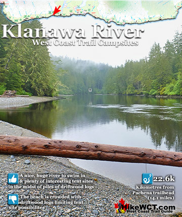
Beautiful Klanawa River Campsite at 22.5km
![]() The campsite at Klanawa River is quite nice because of its lovely, swimmable river, expansive beach and serenity relative to other West Coast Trail campsites.. Though the beach is a thick, tangle of driftwood, you can still manage to find cleared areas perfect for a tent. Klanawa River is just a couple kilometres from Tsusiat Falls. Tsusiat Falls is pretty impressive and hardly any West Coast Trail hikers don't camp there. This leaves few people at Klanawa River. Nice beach and a wonderfully huge river, the Klanawa River campground is fantastic. And because it is close to the super popular Tsusiat Falls campground it is often quiet and serene. Also, the main trail runs to the cable car crossing which diverts the crowds away. At Klanawa River you will find the water flowing past wide and slow.
The campsite at Klanawa River is quite nice because of its lovely, swimmable river, expansive beach and serenity relative to other West Coast Trail campsites.. Though the beach is a thick, tangle of driftwood, you can still manage to find cleared areas perfect for a tent. Klanawa River is just a couple kilometres from Tsusiat Falls. Tsusiat Falls is pretty impressive and hardly any West Coast Trail hikers don't camp there. This leaves few people at Klanawa River. Nice beach and a wonderfully huge river, the Klanawa River campground is fantastic. And because it is close to the super popular Tsusiat Falls campground it is often quiet and serene. Also, the main trail runs to the cable car crossing which diverts the crowds away. At Klanawa River you will find the water flowing past wide and slow.


Swimming in Klanawa River
The river is deep enough to dive into from the riverbank. Which is the best way to get in as it is always surprisingly cold. There are several nice places in the morass of tangled driftwood logs to put up a tent. This gives you a nice feeling of having partial walls and you are never more than a metre away from a log to sit on. In the forest you will find a few more, very nice and also serene feeling clearings for tents. Always with a perfect little fire ring in the centre and sometimes with log furniture surrounding. It is hard to say where is better for your tent, in the wild, deep forest or the wild, driftwood scattered beach. The forest is a bit more cozy feeling and especially suited for a campfire in the forest.

Quiet and Beautiful Klanawa River
The beach, however has the benefit of a perfectly smooth, sand surface under your tent and the ever present river and ocean view. You have the same amenities at Klanawa River as you do at most other West Coast Trail campsites. Outhouses and animal proof food boxes. The water from Klanawa River is nice, clean and just steps away. Beware of skinny dipping in the river, the trail runs on the opposite side of the river behind a narrow band of trees! Possibly the most endearing feature of the campsite at Klanawa River is how beautifully quiet it is. Nobody camps here and everyone camps at the nearby Tsusiat Falls. Almost every hiker passes by without even a look at the beach. Camping here one night is recommended before or after a night at Tsusiat Falls.
Klanawa River Crossing
![]() Klanawa River is a contender for the most underrated place on the West Coast Trail because it is located just two kilometres from Tsusiat Falls. Tsusiat Falls is such a popular campsite that in recent years campers are restricted to only one night there. Tsusiat is beautiful, there is no question, but Klanawa is absolutely wonderful for a whole bunch of reasons. First of course is its lack of popularity means you will have this wonderful place to yourself almost certainly. Second, the river is huge and slow moving, with a smooth pebble shore that is somewhat steep sided. That means you can jump in from the shore into your own giant swimming pool and float on your back to the ocean. The cable car crossing is within site of your camp if you choose to camp on the beach, which of course you would because you have the whole campsite to yourself. After sunset the swimming is even more wonderful as you can only sense your surroundings in shadows and trees against the stars.
Klanawa River is a contender for the most underrated place on the West Coast Trail because it is located just two kilometres from Tsusiat Falls. Tsusiat Falls is such a popular campsite that in recent years campers are restricted to only one night there. Tsusiat is beautiful, there is no question, but Klanawa is absolutely wonderful for a whole bunch of reasons. First of course is its lack of popularity means you will have this wonderful place to yourself almost certainly. Second, the river is huge and slow moving, with a smooth pebble shore that is somewhat steep sided. That means you can jump in from the shore into your own giant swimming pool and float on your back to the ocean. The cable car crossing is within site of your camp if you choose to camp on the beach, which of course you would because you have the whole campsite to yourself. After sunset the swimming is even more wonderful as you can only sense your surroundings in shadows and trees against the stars.

More Storm Battered Trail and Mud
The hilariously bizarre and battered boardwalk continues along this stretch of trail. Some sections like this one are so brutalized by the forest that they appear to have several causes. Multiple trees crashing down crushing a section of boardwalk, breaking it and lifting it into a funny position of leading to an abrupt drop.

Cliff Overlooking the Uncle John Shipwreck
![]() The Uncle John was a 138 foot, three masted barkentine of 314 tons. Built in Eureka, California in 1881 and wrecked one kilometre east of Tsusiat Falls on the West Coast Trail. She was inbound in ballast from Hololulu, heading to Port Townsend. Owing to awful weather and heavy seas, the captain and crew of four were unable to obtain any sights. At 2am on the morning of 6 October, 1899, finally a lighthouse was spotted and it was thought to be the Carmanah Point Lighthouse. Now knowing where they were in relation to the Carmanah Point Lighthouse, Captain Henningsen could now confidently sail into Juan de Fuca Strait. Unfortunately what he thought was Carmanah Point was in fact the Cape Beale Lighthouse and they were sailing directly into the side of Vancouver Island. The wind died down and they slowly inched toward disaster. Their mistake was suddenly realized when breakers were spotted and heard. They quickly dropped the anchor, however they were already being lifted by the heavy swell which was so powerful it snapped the anchor chain. Moments later they hit the reef broadside and the ship was lifted and thrown against the reef over and over. A lifeboat was manned, lowered and as it hit the water was smashed against the ship. The occupants thrown into the water, then pulled back onto the Uncle John which was now lodged against a huge rock shelf surrounded by ocean. They were able to step off the ship onto the rock where they remained, huddled in the darkness soaking wet. The picture here is the stretch of coastline from Tsusiat to Hole Point. The Uncle John was likely lodged against one of these.
The Uncle John was a 138 foot, three masted barkentine of 314 tons. Built in Eureka, California in 1881 and wrecked one kilometre east of Tsusiat Falls on the West Coast Trail. She was inbound in ballast from Hololulu, heading to Port Townsend. Owing to awful weather and heavy seas, the captain and crew of four were unable to obtain any sights. At 2am on the morning of 6 October, 1899, finally a lighthouse was spotted and it was thought to be the Carmanah Point Lighthouse. Now knowing where they were in relation to the Carmanah Point Lighthouse, Captain Henningsen could now confidently sail into Juan de Fuca Strait. Unfortunately what he thought was Carmanah Point was in fact the Cape Beale Lighthouse and they were sailing directly into the side of Vancouver Island. The wind died down and they slowly inched toward disaster. Their mistake was suddenly realized when breakers were spotted and heard. They quickly dropped the anchor, however they were already being lifted by the heavy swell which was so powerful it snapped the anchor chain. Moments later they hit the reef broadside and the ship was lifted and thrown against the reef over and over. A lifeboat was manned, lowered and as it hit the water was smashed against the ship. The occupants thrown into the water, then pulled back onto the Uncle John which was now lodged against a huge rock shelf surrounded by ocean. They were able to step off the ship onto the rock where they remained, huddled in the darkness soaking wet. The picture here is the stretch of coastline from Tsusiat to Hole Point. The Uncle John was likely lodged against one of these.

Tsusiat Falls from Above at 25.2km
As you arrive at Tsusiat Falls, you cross over a small bridge over the shallow water that pours over the cliff. Though the falls drop several metres, you get the illusion from here that the top of the falls and the ocean in the distance are joined.

Tsusiat Falls Ladder Network
The ladder network descending down to the beach next to Tsusiat Falls is enormous. One ladder down to another, then another, then another, then a walkway, then another ladder and another. They go on and on and has to be the most fun approach to any beach on the West Coast Trail.

Beautiful Tsusiat Falls
![]() Tsusiat Falls pours over an abrupt and wide cliff onto the sandy beach. The force of the water has dug out quite a large pool that flows in an ever changing channel through the sand to the ocean. It is quite common to see whales passing in the distance from the beach at Tsusiat. The beach is raised up a few metres from the ocean and affords you a better vantage point over the ocean than you get elsewhere. Tsusiat Falls campsite is wide and extends as far as you want to go down the beach. As everyone has seen pictures of it, everyone aims for it to spend the night. If you don't mind crowds then you'll love it. If you don't like crowds, you may have trouble finding a serene corner to camp.
Tsusiat Falls pours over an abrupt and wide cliff onto the sandy beach. The force of the water has dug out quite a large pool that flows in an ever changing channel through the sand to the ocean. It is quite common to see whales passing in the distance from the beach at Tsusiat. The beach is raised up a few metres from the ocean and affords you a better vantage point over the ocean than you get elsewhere. Tsusiat Falls campsite is wide and extends as far as you want to go down the beach. As everyone has seen pictures of it, everyone aims for it to spend the night. If you don't mind crowds then you'll love it. If you don't like crowds, you may have trouble finding a serene corner to camp.

Beautiful Tsusiat Beach
Tsusiat Beach is very nice with the falls cutting a deep and ever-changing channel through the beach to the ocean.

Tsusiat Beach Cave
Way down the beach you come to a well concealed cave nestled into the cliffs. Huge driftwood logs are scattered along its opening. Inside you usually find a circle of log seats around a fire.

Tsusiat Falls Campsite
![]() One of the most popular and beautiful campsites along the West Coast Trail. Tsusiat Falls is one of the main highlights on the trail with its dramatically wide and beautifully picturesque appearance. You will find Tsusiat Falls at the base of an extraordinary array of ladders extending hundreds of metres up into the trees. Tsusiat Falls pours over an abrupt and wide cliff onto the sandy beach. The force of the water has dug out quite a large pool that flows in an ever changing channel through the sand to the ocean. It is quite common to see whales passing in the distance from the beach at Tsusiat. The beach is raised up a few metres from the ocean and affords you a better vantage point over the ocean than you get elsewhere.
One of the most popular and beautiful campsites along the West Coast Trail. Tsusiat Falls is one of the main highlights on the trail with its dramatically wide and beautifully picturesque appearance. You will find Tsusiat Falls at the base of an extraordinary array of ladders extending hundreds of metres up into the trees. Tsusiat Falls pours over an abrupt and wide cliff onto the sandy beach. The force of the water has dug out quite a large pool that flows in an ever changing channel through the sand to the ocean. It is quite common to see whales passing in the distance from the beach at Tsusiat. The beach is raised up a few metres from the ocean and affords you a better vantage point over the ocean than you get elsewhere.


Huge and Popular Tsusiat Falls Campsite
Tsusiat Falls campsite is wide and extends as far as you want to go down the beach. As everyone has seen pictures of it, everyone aims for it to spend the night. If you don't mind crowds then you'll love it. If you don't like crowds, you may have trouble finding a serene corner to camp. If you really want to find serenity, you might try camping at the far end of the beach where you will find quite a large sea cave. If you love waking up to whales in the distance and the beautiful roar of waterfalls nearby, then you will find that at Tsusiat. The campsite is well designed for crowds though as the hundreds of driftwood logs on the beach have fashioned partitioned areas randomly, where some sort of organized privacy exists.


West Coast Trail Day 3: Tsusiat to Carmanah
The West Coast Trail by Day

West Coast Trail Campsites
The Valencia Disaster
Explore BC Hiking Destinations!
The West Coast Trail
Victoria Hiking Trails
Clayoquot Hiking Trails
Whistler Hiking Trails
Squamish Hiking Trails

Vancouver Hiking Trails