![]() Day 1 on the West Coast Trail hiking south from the Pachena trailhead is a fairly relaxing first day. Your first beach, Pachena Beach is a lovely, wide, sandy arch that stretches to a thick wall of forest on either end. As you look past the beautiful beach and size up the thick wilderness that hides the start of the trail, you can't help but be struck by the vast jungle rainforest. The trees are so thick that they spill over the ocean and you can't see even a few metres beyond the abrupt, rocky coastline.
Day 1 on the West Coast Trail hiking south from the Pachena trailhead is a fairly relaxing first day. Your first beach, Pachena Beach is a lovely, wide, sandy arch that stretches to a thick wall of forest on either end. As you look past the beautiful beach and size up the thick wilderness that hides the start of the trail, you can't help but be struck by the vast jungle rainforest. The trees are so thick that they spill over the ocean and you can't see even a few metres beyond the abrupt, rocky coastline.
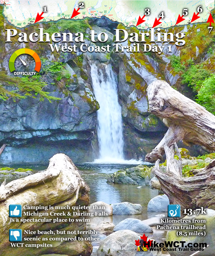
 Pachena Beach is a wild & pretty start to the WCT
- Pachena to Darling River is mostly easy hiking
- Sea Lion Haul Out Rock is found at 9km
- You can visit the Pachena Lighthouse at 10km
- See your first WCT shipwrecks at Michigan & Darling
- Swimming at Darling Falls is wonderful & secluded
- Darling Beach is less busy than Michigan Beach
 The beaches on this stretch are not the nicest
- Low tide reveals a bit of an ugly shoreline
- There are not a lot of great tent sites
The West Coast Trail
![]() Prologue
Prologue ![]() 1: The West Coast Trail
1: The West Coast Trail ![]() 2: When to Hike & Fees
2: When to Hike & Fees ![]() 3: Trailheads
3: Trailheads ![]() 4: Getting There
4: Getting There ![]() 5: Considerations
5: Considerations ![]() 6: Campsites
6: Campsites ![]() 7: Shipwrecks
7: Shipwrecks ![]() 8: Routes
8: Routes ![]() Day 1 Pachena to Darling
Day 1 Pachena to Darling ![]() Day 2 Darling to Tsusiat
Day 2 Darling to Tsusiat ![]() Day 3 Tsusiat to Carmanah
Day 3 Tsusiat to Carmanah ![]() Day 4 Carmanah to Walbran
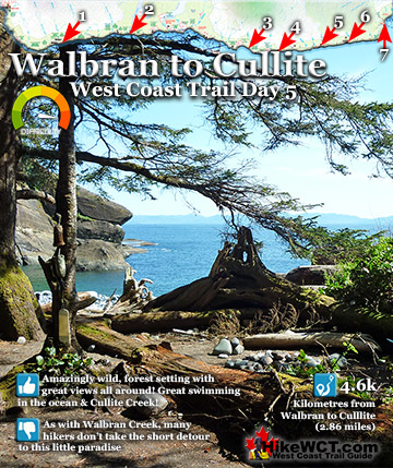
Day 4 Carmanah to Walbran ![]() Day 5 Walbran to Cullite
Day 5 Walbran to Cullite ![]() Day 6 Cullite to Camper
Day 6 Cullite to Camper ![]() Day 7 Camper to Thrasher
Day 7 Camper to Thrasher ![]() Michigan Creek at 12k
Michigan Creek at 12k ![]() Darling River at 14k
Darling River at 14k ![]() Orange Juice Creek at 15k
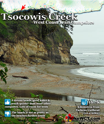
Orange Juice Creek at 15k ![]() Tsocowis Creek at 16.5k
Tsocowis Creek at 16.5k ![]() Klanawa River at 23k
Klanawa River at 23k ![]() Tsusiat Falls at 25k
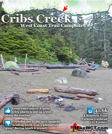
Tsusiat Falls at 25k ![]() Cribs Creek at 42k
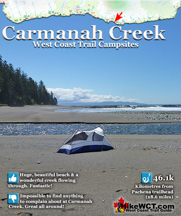
Cribs Creek at 42k ![]() Carmanah Creek at 46k
Carmanah Creek at 46k ![]() Bonilla Creek at 48k
Bonilla Creek at 48k ![]() Walbran Creek at 53k
Walbran Creek at 53k ![]() Cullite Cove at 58k
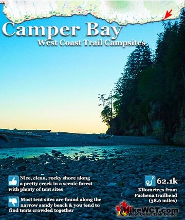
Cullite Cove at 58k ![]() Camper Bay at 62k
Camper Bay at 62k ![]() Thrasher Cove at 70
Thrasher Cove at 70
What is most striking about the view from the beach is the utter lack of humanity. No signs, no people, nothing. You can imagine this view as it would have been a thousand years ago. Or just a century ago when the Graveyard of the Pacific was earning its ominous name. If you look out from Pachena Beach, not far past the entrance of the bay you will be looking over the shipwreck sites of the Alaskan and the Soquel. Hidden from view under the waves, you won't get to see and touch your first West Coast Trail shipwreck until you get to Michigan Creek at 12km. Here you will find the massive boiler of the Michigan that wrecked here in 1893. Starting the West Coast Trail from Pachena Beach you will notice the trail markers start from here and you will soon spot the 1 kilometre marker. They continue until the 75 kilometre marker just before the trailhead exit at Gordon River. Hiking to the 14 kilometre mark at Darling River is a good distance for your first day on the trail. Having a nice place to camp is a very important part of the West Coast Trail. As you will likely be camping at 5, 6 or 7 different campsites out of a possible 13 campsites along the trail, picking the best ones make your adventure much more memorable.
West Coast Trail Day 1 Pachena to Darling Map

Pachena Bay Trailhead West Coast Trail
![]() After you are dropped off or park your car at the Pachena Bay trailhead in Bamfield you will have to do the mandatory orientation session at the little West Coast Trail building. Through the trees, and just a few metres away you catch your first glimpse of what lies ahead on your hike along the wild West Coast of Vancouver Island. A beautiful, big sandy beach, with forest extending on ether side like two giant tree covered arms. Pachena Bay is wonderfully tranquil and surprisingly devoid of people or structures. Staring out at the bay you can't see any signs of humanity and wonder why there are no people enjoying this gorgeous place. Then you recall the long journey you took to get here and realize how relatively few people live in this area. Also, along this quiet and wild coast, there are no shortage of great beaches. The next beach over is probably just as nice, and the next one and the next one after that.
After you are dropped off or park your car at the Pachena Bay trailhead in Bamfield you will have to do the mandatory orientation session at the little West Coast Trail building. Through the trees, and just a few metres away you catch your first glimpse of what lies ahead on your hike along the wild West Coast of Vancouver Island. A beautiful, big sandy beach, with forest extending on ether side like two giant tree covered arms. Pachena Bay is wonderfully tranquil and surprisingly devoid of people or structures. Staring out at the bay you can't see any signs of humanity and wonder why there are no people enjoying this gorgeous place. Then you recall the long journey you took to get here and realize how relatively few people live in this area. Also, along this quiet and wild coast, there are no shortage of great beaches. The next beach over is probably just as nice, and the next one and the next one after that.

Beach Route or Forest Trail at Pachena Bay
Standing on Pachena Beach and looking left you see a solid wall of forest extending along the shoreline with the West Coast Trail hidden within. You can walk along the beach and link onto the West Coast Trail in just a couple hundred metres or start from the trailhead just off the beach and immediately enter the forest. You will get used to this choice along the West Coast Trail as you often have a beach route as well as a forest trail. The beach routes tend to be preferred, however walking on soft sand gets tiring as you sink in and feel like every step takes you one step forward and a half step back. Many of the beach routes are solid rock shelfs, which are faster, though you often have to tend with very slippery and slimy rock. The first 12 kilometres of the West Coast Trail, with the exception of the short Pachena Beach section, is forest trail only. Compared to the forest sections beyond, the first 12km are very easy and relaxing.

You catch the occasional nice glimpse of Pachena Bay as you hike along mostly easy and flat terrain along the first few minutes of the trail.

West Coast Trail Ladders into the Rainforest
Not far from the trailhead at Pachena Beach, about 10 minutes along the trail you enter the forest and come to your first ladder up into the trees away from the beach and into the rainforest. This is the first of many ladders and a tiny one compared to most of the rest you will soon encounter. Made of cedar which is resistant to rot, many of these ladders have been here for decades and the rungs have two very noticeable depressions worn into them from thousands of hikers boots.

The rainforest surrounds you and forces its way into everything around you. You quickly start to grasp what a monumental job it is to maintain the West Coast Trail. After the harsh winter weather there are knocked down trees splayed across the trail. In the spring months the trail is very muddy and some attempts have been made to cross the mud, but its a pretty monumental task.

Variety of West Coast Trail Ladders
The ladders on the West Coast Trail are wonderful. The variety you get is always a surprise. Some are sloping, others are vertical, many ladders end at a small platform, then another ladder continues, then another platform, then another ladder. And with the encroaching forest, you can often only see a few metres up or down and can't tell how high or low you are going. Extraordinary!

West Coast Trail ladders are definitely a great feature of the trail and after trudging through the forest for a while, coming to one gives you the thought that something exciting is up ahead like a beach or river crossing.

The Winter Battered West Coast Trail
The destructive power of the winters here is evident in areas along the trail where trees have smashed down on the trail. Trees bent and broken over the trail. If the fallen trees don't block the trail too much, it will be left by maintenance crews. Something you see very often in the form of enormous trees arching over the trail, forcing you to duck under. It is a nice thing that these are left as each one becomes a marvel. You can't help but replay in your head the moment the tree came crashing down.

Deadfall, Windthrow and Blowdown
The incredible number of mangled, deadfall laying across the trail makes it much more interesting and beautiful. Having to duck under a pair of enormous trees, one of them ripped apart makes you wonder what kind of violent storm could do that to a tree. You instinctively assume that many of the trees laying across the trail at eye level have fallen here years ago, but after a closer look it is clear many are just from the past winter and maybe in recent weeks. There are a few words to describe the various specific types of fallen trees in the forest. Deadfall is the more generalized term that literally means dead and fallen, as in a dead and fallen tree. Windthrow and blowdown are slightly more specific in that they refer to trees blown over and uprooted by strong winds during storms. Encountering a tree on the West Coast Trail laying across the trail you would call a deadfall, or more specifically a blowdown or windthrow.

The Extraordinary Phenomenon of Windsnap
If a tree did not uproot, but instead was broken along its trunk would be called windsnap. These are often the most impressive ones to see as they are so brutal in appearance and make you wonder what kind of powerful storm could have broken a tree in two!

Shipwrecks 5km-8km - West Coast Trail Day 1
One the first day of the West Coast Trail you don't get very close to any shipwrecks. Partly because you hike through the forest and not along the ocean, but mainly because the wrecks have disintegrated and hide underwater. You do get one great benefit from being in the forest, that is the frequent ocean views from high up. From this height you get a great vantage point to where these ships met their end. The Becherdass-Ambiadass shipwreck occurred near the 8km mark of the West Coast Trail and there is great view of the ocean overlooking where she went down in 1879.

The Alaskan Shipwreck Near KM4
![]() The Alaskan was last seen from Pachena Point apparently unable to round Cape Beale due to high winds and she evidently had turned back. Distress flares were reportedly spotted in the evening from witnesses. No one witnessed its destruction and the Alaskan is believed to have foundered just after 7pm on January 2nd, 1923, killing the entire crew of 11. Three bodies washed ashore with considerable debris on the beaches west of Pachena Point. You will pass the location of the Alaskan shipwreck at about the 4km mark on the West Coast Trail, however there is no visible indication of the wreck for hikers to see.
The Alaskan was last seen from Pachena Point apparently unable to round Cape Beale due to high winds and she evidently had turned back. Distress flares were reportedly spotted in the evening from witnesses. No one witnessed its destruction and the Alaskan is believed to have foundered just after 7pm on January 2nd, 1923, killing the entire crew of 11. Three bodies washed ashore with considerable debris on the beaches west of Pachena Point. You will pass the location of the Alaskan shipwreck at about the 4km mark on the West Coast Trail, however there is no visible indication of the wreck for hikers to see.
The Alaskan shipwreck continued here...
The Soquel Shipwreck Near KM5
![]() The Soquel shipwreck, which lies just past Seabird Rocks, was a much larger ship than the Alaskan at 698 tons. She was a four masted schooner built in San Francisco, California in 1902. The Soquel was sailing with ballast from Callao, Peru, heading for Port Townsend (near Seattle), when bad weather and high seas carried her far off course. The crew of 12 battled the storm as it continued to worsen, toppling two of the ship's four masts. The captains wife and daughter were killed by falling spars when the masts came crashing down on them. Throughout the night they struggled to reach a safe place to escape the storm. At some point during the the night she ran aground. The next morning, on January 22nd, 1909, the Soquel was spotted, aground on Seabird Rocks. The recently organized Bamfield lifesaving crew began a rescue operation. They battled the huge waves with their steamer, however unable to get close enough to perform a rescue. A few hours later, a second steamer arrived on the scene and together they managed to save five of the crew. Darkness prevented further rescue and the seven remaining crew had to wait out the night on the wrecked ship. The next morning calmer seas enable the rescue the remaining survivors as well as the bodies of the captain's wife and child. You will pass the presumed location of the Soquel shipwreck at about the 5km mark on the West Coast Trail, however there is no visible indication of the wreck for hikers to see.
The Soquel shipwreck, which lies just past Seabird Rocks, was a much larger ship than the Alaskan at 698 tons. She was a four masted schooner built in San Francisco, California in 1902. The Soquel was sailing with ballast from Callao, Peru, heading for Port Townsend (near Seattle), when bad weather and high seas carried her far off course. The crew of 12 battled the storm as it continued to worsen, toppling two of the ship's four masts. The captains wife and daughter were killed by falling spars when the masts came crashing down on them. Throughout the night they struggled to reach a safe place to escape the storm. At some point during the the night she ran aground. The next morning, on January 22nd, 1909, the Soquel was spotted, aground on Seabird Rocks. The recently organized Bamfield lifesaving crew began a rescue operation. They battled the huge waves with their steamer, however unable to get close enough to perform a rescue. A few hours later, a second steamer arrived on the scene and together they managed to save five of the crew. Darkness prevented further rescue and the seven remaining crew had to wait out the night on the wrecked ship. The next morning calmer seas enable the rescue the remaining survivors as well as the bodies of the captain's wife and child. You will pass the presumed location of the Soquel shipwreck at about the 5km mark on the West Coast Trail, however there is no visible indication of the wreck for hikers to see.
The Soquel shipwreck continued here...
The Sarah Shipwreck Near KM7
![]() The captain of the Sarah sighted the recently built Carmanah Point Lighthouse and mistook it for the Cape Flattery Lighthouse. The Sarah struggled against the south-east wind and the ship was pushed westward. Later the crew was able to regain their eastward coarse, toward what they though was Juan de Fuca Strait. The ocean current had moved the ship considerably far north and on the evening of the 8th November, 1891, the crew was surprised to suddenly hear distant breakers. They immediately dropped anchor, then shortly after another one. But it was too late, the Sarah ran aground on the shore of what is now KM7 of the West Coast Trail. One lifeboat was freed with some of the crew, however the captain, the rest of his crew and his wife and baby remained because the second lifeboat could not be freed. Throughout the following day and night they struggled to free the boat to make their escape to safety. Two of the crew drowned in attempting to reach the shore in a makeshift raft. Finally they managed to free another lifeboat and the survivors managed to get ashore. They were rescued by one of the many indigenous tribes residing on Vancouver Island. It seems safe to assume that it was the Huu-ay-aht First Nations which resided there, as they do now, at Pachena Bay. The Huu-ay-aht brought the shipwreck survivors to a trader's post where they found passage to Victoria on a local schooner. 16 of the crew of 18 and the captain's wife and baby survived the Sarah shipwreck.
The captain of the Sarah sighted the recently built Carmanah Point Lighthouse and mistook it for the Cape Flattery Lighthouse. The Sarah struggled against the south-east wind and the ship was pushed westward. Later the crew was able to regain their eastward coarse, toward what they though was Juan de Fuca Strait. The ocean current had moved the ship considerably far north and on the evening of the 8th November, 1891, the crew was surprised to suddenly hear distant breakers. They immediately dropped anchor, then shortly after another one. But it was too late, the Sarah ran aground on the shore of what is now KM7 of the West Coast Trail. One lifeboat was freed with some of the crew, however the captain, the rest of his crew and his wife and baby remained because the second lifeboat could not be freed. Throughout the following day and night they struggled to free the boat to make their escape to safety. Two of the crew drowned in attempting to reach the shore in a makeshift raft. Finally they managed to free another lifeboat and the survivors managed to get ashore. They were rescued by one of the many indigenous tribes residing on Vancouver Island. It seems safe to assume that it was the Huu-ay-aht First Nations which resided there, as they do now, at Pachena Bay. The Huu-ay-aht brought the shipwreck survivors to a trader's post where they found passage to Victoria on a local schooner. 16 of the crew of 18 and the captain's wife and baby survived the Sarah shipwreck.
The Sarah shipwreck continued here...
The Becherdass-Ambiadass Shipwreck Near KM8
![]() Built in 1864 the 1376 ton, 3 masted ship, Becherdass-Ambiadass was wrecked on the rocky shore only a half mile from Pachena Point. This British ship was returning from Shanghai to Moodyville (now North Vancouver) when Cape Beale was sighted. As she neared Vancouver Island early morning fog blinded her and under full sail collided with the abruptly rocky shore near the 8km mark of the West Coast Trail. Amazingly no one was seriously hurt, but the ship was wrecked. The crew used the lifeboats to save themselves. The next day a local boat carried both the crew and their belongings to Victoria. In the following weeks the ship disintegrated on the rocks. There are no remnants of wreckage from the Becherdass-Ambiadass shipwreck to see. The wreck sits under the waves not far from where the Black River meets the ocean near KM8 along the West Coast Trail.
Built in 1864 the 1376 ton, 3 masted ship, Becherdass-Ambiadass was wrecked on the rocky shore only a half mile from Pachena Point. This British ship was returning from Shanghai to Moodyville (now North Vancouver) when Cape Beale was sighted. As she neared Vancouver Island early morning fog blinded her and under full sail collided with the abruptly rocky shore near the 8km mark of the West Coast Trail. Amazingly no one was seriously hurt, but the ship was wrecked. The crew used the lifeboats to save themselves. The next day a local boat carried both the crew and their belongings to Victoria. In the following weeks the ship disintegrated on the rocks. There are no remnants of wreckage from the Becherdass-Ambiadass shipwreck to see. The wreck sits under the waves not far from where the Black River meets the ocean near KM8 along the West Coast Trail.

The Becherdass-Ambiadass shipwreck continued here...
Sea Lion Haul Out Rock at 9km - West Coast Trail Day 1
At about the 9 kilometre mark on the West Coast Trail you will come to your first marvellous view of wildlife. Sea Lion Haul Out Rock is a gathering place for Steller sea lions. Every year in May, reproductively mature sea lions return to this rookery. A rookery is a clearly defined breeding ground for colony forming sea birds and marine mammals. Dominant males stake out territories on the rookery and a few days later adult females arrive, usually pregnant from the previous season. Shortly after arriving, the females give birth and start mating again within a couple weeks. Females go foraging for food after nursing for a week, however reproductive males usually remain on the rookery, usually without entering the water until August! August is when the colony disperses back to the ocean, returning again the following spring.

The king of the sea lions. From the cliffs along the West Coast Trail you get to see this whole other world at a distance. Hundreds of sea lions oblivious to your existence up in the forest go about their life on their secure castle fortress surrounded by ocean.

Pachena Point Lighthouse at 10k - West Coast Trail Day 1
![]() The Pachena Point Lighthouse is an interesting bit of west coast history that you can visit. You can only see the grounds outside and not in the lighthouse itself. The view down from the 100 foot cliffs surrounding the lighthouse are beautiful and a vivid look at how powerful the crashing waves are. Pachena Point is the menacing point of land out to the left if you are standing next to the lighthouse. Pachena Point was originally named Beghadoss Point after the Becherdass-Ambiadass shipwreck that occurred here on July 27th, 1879. The name Beghadoss was the original name of the Becherdass-Ambiadass. When the lighthouse was completed in 1907 the name of the point and lighthouse were changed to Pachena Point and Pachena Point Lighthouse. The name is thought to come from the word pacheenah. A word that the Indigenous hunters along the coast used for seafoam. It is also reported that Pachena was easier for Canadians to pronounce than Beghadoss. It is a stark reminder to how treacherous the Graveyard of the Pacific is here, that despite the newly constructed lighthouse, shipwrecks continued to occur in the area. The Soquel wrecked near here in 1909, the Varsity in 1940 and the Uzbekistan in 1943!
The Pachena Point Lighthouse is an interesting bit of west coast history that you can visit. You can only see the grounds outside and not in the lighthouse itself. The view down from the 100 foot cliffs surrounding the lighthouse are beautiful and a vivid look at how powerful the crashing waves are. Pachena Point is the menacing point of land out to the left if you are standing next to the lighthouse. Pachena Point was originally named Beghadoss Point after the Becherdass-Ambiadass shipwreck that occurred here on July 27th, 1879. The name Beghadoss was the original name of the Becherdass-Ambiadass. When the lighthouse was completed in 1907 the name of the point and lighthouse were changed to Pachena Point and Pachena Point Lighthouse. The name is thought to come from the word pacheenah. A word that the Indigenous hunters along the coast used for seafoam. It is also reported that Pachena was easier for Canadians to pronounce than Beghadoss. It is a stark reminder to how treacherous the Graveyard of the Pacific is here, that despite the newly constructed lighthouse, shipwrecks continued to occur in the area. The Soquel wrecked near here in 1909, the Varsity in 1940 and the Uzbekistan in 1943!

Pachena Cable Pully
A short trail takes you to the lighthouse where you can do a tour of the outside. One surprising thing you encounter is a long cable pulley stretching down to the reef far below. This cable is used to receive supplies from boats that drop things off to this natural dock.

Pachena Lighthouse Miles To Sign
Next to the lighthouse there is a sign indicating how far and in what direction different countries are.

Michigan Beach Campsite at 12k - West Coast Trail Day 1
![]() The campsite at Michigan Creek is the first or last campsite you will encounter on the West Coast Trail. First if you begin your hike at the Pachena trailhead(hiking south) and last if you begin in Port Renfrew(hiking north). The 12.1 kilometres(7.5 miles) between the Pachena trailhead and Michigan Creek is fairly easy and flat. Compared to the rest of the West Coast Trail, this section is wonderfully relaxing. At a brisk pace, you should be able to hike this section in a little over 3 hours. At a more relaxed pace, and stopping at the Pachena Point Lighthouse, you will take 4 or 5 hours from the trailhead. Certainly the highlight of Michigan Creek is the extraordinary remnant of the Michigan shipwreck trapped on the rocky shelf revealed by low tide.
The campsite at Michigan Creek is the first or last campsite you will encounter on the West Coast Trail. First if you begin your hike at the Pachena trailhead(hiking south) and last if you begin in Port Renfrew(hiking north). The 12.1 kilometres(7.5 miles) between the Pachena trailhead and Michigan Creek is fairly easy and flat. Compared to the rest of the West Coast Trail, this section is wonderfully relaxing. At a brisk pace, you should be able to hike this section in a little over 3 hours. At a more relaxed pace, and stopping at the Pachena Point Lighthouse, you will take 4 or 5 hours from the trailhead. Certainly the highlight of Michigan Creek is the extraordinary remnant of the Michigan shipwreck trapped on the rocky shelf revealed by low tide.

The huge boiler of the Michigan is so large that it sits ominously in a depression on the rocky shelf near where it drops off to deeper ocean. From the sandy shoreline, this rusty hulk sits about 70 metres away as large waves constantly pound it. You can easily walk out to it when the tide is low and get a close look at just a couple metres away. Getting close enough to touch it will require a short and cold plunge into the ocean with swirling water all around.


Because this campsite is the first or last campsite for hikers on the West Coast Trail it is always busy and you should pick one of the nearby campsites. Darling River, Orange Juice Creek and Tsocowis Creek campsites are all better than Michigan and just down the beach. Also, the beach at Michigan Creek is not very nice and your view is largely seaweed covered rock. Though the areas to camp in the forest are quite nice, you still get the mediocre beach views through the trees.


Should You Camp at Michigan Creek?
Should you camp at Michigan Creek? No, there are better options close by. If you are heading north to the trailhead and heavy rain is expected you may want to camp at Michigan so you don't have to get across Darling River. Darling River is a much nicer place to camp because it is less popular and sits next to the remarkable Darling Falls. A beautiful little hideaway, just a short walk up Darling River. Somehow every guidebook, website and blog on the West Coast Trail misses this little paradise. Certainly the highlight of the first(or last) day on the trail!
Michigan Shipwreck at 12k - West Coast Trail Day 1
![]() The Michigan shipwreck on the West Coast Trail is the first one you can see and actually touch, which is incredible since it is well over a century old. On January 21st, 1893 this 695 ton steam schooner was heading to Puget Sound from San Francisco. The strong northerly current that prevails in this part of the Pacific and would eventually cause dozens of shipwrecks, caused the Michigan to massively overrun her position. Instead of sailing into Juan de Fuca Strait, she collided with Vancouver Island in the middle of the night. The 25 people on board managed to get ashore after daylight. The the seas calmed the crew was able to retrieve a boat from the wreck and was able to get to Neah Bay for assistance. A ship rescue was attempted, but was not successful. One death resulted from the attempt to hike over the old telegraph trail to Carmanah Point. A testament to how difficult it was then as compared to how relatively easy the West Coast Trail is now.
The Michigan shipwreck on the West Coast Trail is the first one you can see and actually touch, which is incredible since it is well over a century old. On January 21st, 1893 this 695 ton steam schooner was heading to Puget Sound from San Francisco. The strong northerly current that prevails in this part of the Pacific and would eventually cause dozens of shipwrecks, caused the Michigan to massively overrun her position. Instead of sailing into Juan de Fuca Strait, she collided with Vancouver Island in the middle of the night. The 25 people on board managed to get ashore after daylight. The the seas calmed the crew was able to retrieve a boat from the wreck and was able to get to Neah Bay for assistance. A ship rescue was attempted, but was not successful. One death resulted from the attempt to hike over the old telegraph trail to Carmanah Point. A testament to how difficult it was then as compared to how relatively easy the West Coast Trail is now.
Darling River Campsite at 14k - West Coast Trail Day 1
![]() Just 2 kilometres past the popular and chaotic Michigan Creek campsite you will come to the Darling River crossing. Depending on the rainfall of previous days, you may walk through the river just a couple centimetres deep or a rushing torrent thigh deep. When it is deep and fast moving may find it difficult to get across without slipping or getting knocked over by the current. This is one of the creek crossing they warn you about at the West Coast Trail orientation, and some hikers get caught behind it waiting for it to subside. Most of the time when there hasn't been significant rain, you will barely get your shoes wet crossing.
Just 2 kilometres past the popular and chaotic Michigan Creek campsite you will come to the Darling River crossing. Depending on the rainfall of previous days, you may walk through the river just a couple centimetres deep or a rushing torrent thigh deep. When it is deep and fast moving may find it difficult to get across without slipping or getting knocked over by the current. This is one of the creek crossing they warn you about at the West Coast Trail orientation, and some hikers get caught behind it waiting for it to subside. Most of the time when there hasn't been significant rain, you will barely get your shoes wet crossing.

After you cross, you will have arrived at the Darling River campsite. Mostly nestled along the treeline, the Darling River campsite is relatively quiet compared to Michigan Creek. The significant draw to Darling River is not the campsite, but rather the idyllic waterfalls that can be found just a few hundred metres up the river.

Darling Falls is a beautiful little hidden paradise that most hikers evidently miss completely. The emerald green water cascades down just a couple meters from a narrow channel in the rock. A perfect place to swim surrounded by stunning forest. Darling River flows down to the ocean through a beautifully chaotic collection of driftwood and massive logs.


Darling Beach Camping
Darling Beach has a seemingly endless number of clearings next to treeline amongst the erratic mess of driftwood. The sand is soft and you are just steps from a food cache box and outhouse back in the forest.

Darling Beach Rain Camp
You can always find some shelter from the frequent West Coast Trail rain by nudging in amongst the ever-present driftwood constructions.

Should You Camp at Darling River?
Should you camp at the Darling River campsite? Definitely. Darling Falls and Darling River make this mediocre West Coast Trail beach and campsite exceptional. Darling Falls is one of those rare waterfalls that you find in movies where our heroes stumble upon after getting lost. It is a hidden, emerald coloured world that entices you to throw off your clothes and dive into. Washing off the the sweat and grime of the day.

Uzbekistan Shipwreck at 14k - West Coast Trail Day 1
![]() The Uzbekistan was a steel steamship of 2569 tons. Built in 1937 in France and became a shipwreck on April 1st, 1943. A Russian ship, the Uzbekistan was part of the lend-lease program during World War II, where the US shipped war materials to Russia. She left Portland for Seattle to pick up a load of war materials destined for Vladivostok. On April 1st 1943 the Uzbekistan encountered stormy weather and bad visibility, mistaking the light at Swiftsure Bank for that of Umatilla Reef. She steered toward what was thought to be Juan de Fuca Strait. Because of the strong northerly current, she was far north of her supposed location. At 11pm the Uzbekistan collided with the the rocky shelf just down from today's Darling River. The entire crew made it to shore safely and made camp. They then managed to hike their way to Bamfield and were eventually picked up by a Royal Canadian Navy ship. Today, if you are lucky you can spot the Uzbekistan's boilers and parts of her propulsion machinery at very low tide at the edge of the reef. You will more easily spot pieces of steel scattered around the mouth of Darling River.
The Uzbekistan was a steel steamship of 2569 tons. Built in 1937 in France and became a shipwreck on April 1st, 1943. A Russian ship, the Uzbekistan was part of the lend-lease program during World War II, where the US shipped war materials to Russia. She left Portland for Seattle to pick up a load of war materials destined for Vladivostok. On April 1st 1943 the Uzbekistan encountered stormy weather and bad visibility, mistaking the light at Swiftsure Bank for that of Umatilla Reef. She steered toward what was thought to be Juan de Fuca Strait. Because of the strong northerly current, she was far north of her supposed location. At 11pm the Uzbekistan collided with the the rocky shelf just down from today's Darling River. The entire crew made it to shore safely and made camp. They then managed to hike their way to Bamfield and were eventually picked up by a Royal Canadian Navy ship. Today, if you are lucky you can spot the Uzbekistan's boilers and parts of her propulsion machinery at very low tide at the edge of the reef. You will more easily spot pieces of steel scattered around the mouth of Darling River.

West Coast Trail Day 2: Darling to Tsusiat
The West Coast Trail by Day

West Coast Trail Campsites
The Valencia Disaster

Explore BC Hiking Destinations!

The West Coast Trail
Victoria Hiking Trails

Clayoquot Hiking Trails
Whistler Hiking Trails

Squamish Hiking Trails

Vancouver Hiking Trails