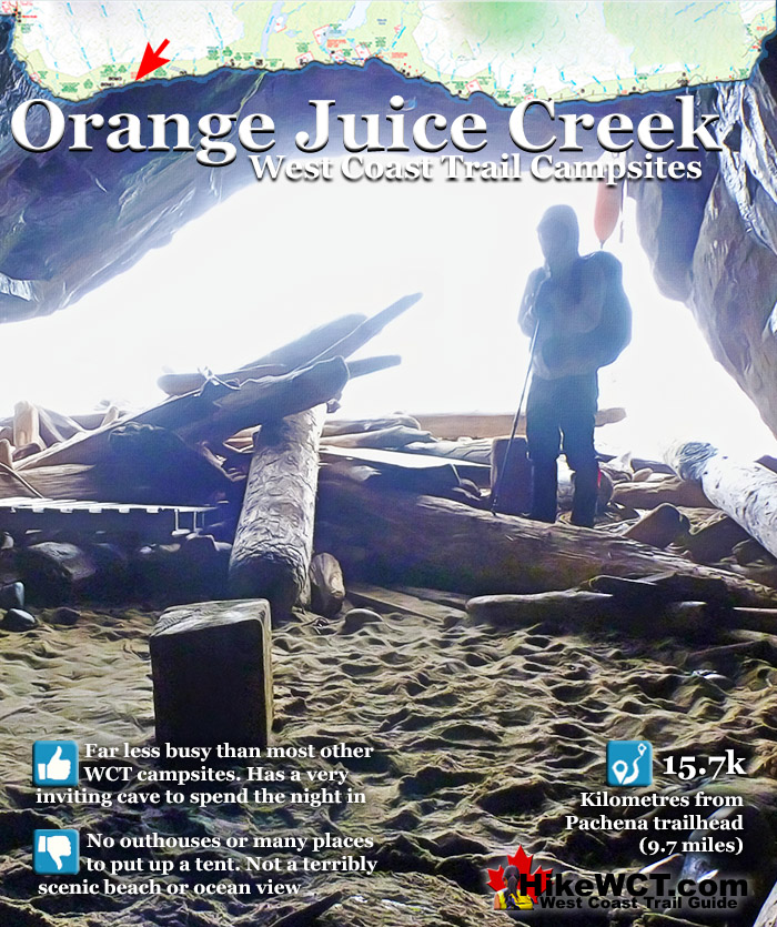
![]() Just a kilometre past the Darling River campsite you will come to another beach campsite at Orange Juice Creek. Orange Juice Creek is not terribly pretty and gets its name from the intensely, orange juice coloured water that crashes through a tangled morass of driftwood logs. If you aren't keen on swimming and/or washing at Darling Falls, Orange Juice Creek is a good alternative.
Just a kilometre past the Darling River campsite you will come to another beach campsite at Orange Juice Creek. Orange Juice Creek is not terribly pretty and gets its name from the intensely, orange juice coloured water that crashes through a tangled morass of driftwood logs. If you aren't keen on swimming and/or washing at Darling Falls, Orange Juice Creek is a good alternative.
 Less busy than most other WCT campsites
- Good water source with Orange Juice Creek
- Interesting cave to explore with old grafitti
- Escape stormy weather in the cave
- Lots of firewood for a perfect WCT campfire
 Orange Juice Creek is not terribly pretty
- Not a lot of exciting spots for a tent
- Not a very scenic beach
- Orange Juice Creek is too shallow to swim
- No outhouses
West Coast Trail Campsites
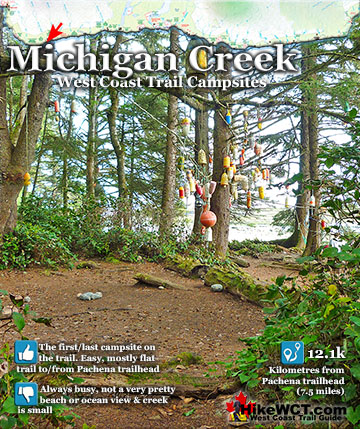
![]() Michigan Creek at 12km
Michigan Creek at 12km ![]() Darling River at 14km
Darling River at 14km ![]() Orange Juice Creek at 15km
Orange Juice Creek at 15km ![]() Tsocowis Creek at 16.5km
Tsocowis Creek at 16.5km ![]() Klanawa River at 23km
Klanawa River at 23km ![]() Tsusiat Falls at 25km
Tsusiat Falls at 25km ![]() Cribs Creek at 42km
Cribs Creek at 42km ![]() Carmanah Creek at 46km
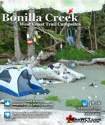
Carmanah Creek at 46km ![]() Bonilla Creek at 48km
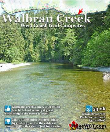
Bonilla Creek at 48km ![]() Walbran Creek at 53km
Walbran Creek at 53km ![]() Cullite Cove at 58km
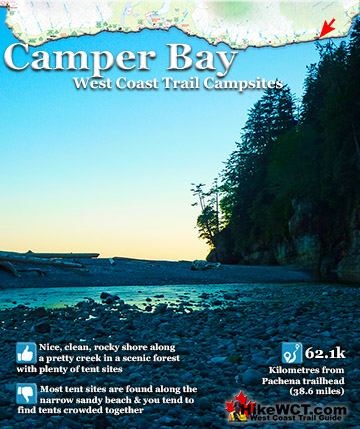
Cullite Cove at 58km ![]() Camper Bay at 62km
Camper Bay at 62km ![]() Thrasher Cove at 70km
Thrasher Cove at 70km
Orange Juice Creek is the third(or third to last) campsite on the West Coast Trail. Michigan Creek, Darling River, Orange Juice Creek and Tsocowis Creek are all along a fairly continuous beach that stretches for 5 kilometres. All are easily within a days hike from or to the Pachena trailhead. Of the four campsites Michigan Creek is by far the busiest and Darling River is definitely best because of its wonderful waterfall. The waterfall is amazing, located in deep forest, pouring through a narrow channel and plunging 2 metres into a crystal clear, emerald coloured pool. In terms of popularity with campers, Orange Juice Creek is considerably quieter than Michigan Creek and much quieter than Darling River. Also, due to the arching shape of the beach and morass of driftwood you will find a more relaxed and private campsite at Orange Juice Creek. One interesting aspect of Orange Juice Creek that makes it worth camping at is the small, but very livable sea cave. Some find it charming, others find it spooky. At the very least it is worth a look. A small fire ring usually sits in the middle, surrounded by driftwood logs for seats. In horribly, wet weather, this cave is paradise, at least if you are looking for an unusual and interesting place to escape the rain. Orange Juice Creek spills from the forest in a bizarre looking reddish, brown torrent onto the beach in the midst of a monstrous tangle of driftwood logs. At first sight, Orange Juice Creek is an ugly mess of logs and murky coloured water. After some closer consideration, the place becomes interesting and even beautiful in a way.
The Strange Colour of Orange Juice Creek
The water is perfectly fine to drink and the murky, colour is just the presence minerals from the forest. The colours come from dissolved organic matter called tannins leeched out of the rainforest. Of course you always have to filter or treat water on the West Coast Trail to avoid any possibility of getting beaver fever. It is also a good idea to bring some sort of drink powder to change the colour of your water from dirty looking brownish orange to a more appetizing red colour.

Orange Juice Creek Campsite Map
![]() The chaotic tangle of driftwood logs is the result of months of harsh winter storms driving them against the treeline. The small waterfall crashing out of the trees is a vicious torrent of water emerging from the trees. The forest is such a thick tangle that forms an almost solid green wall at the edge of the beach. The crashing falls emerge from the dark and deep forest, only visible as they spill over an abrupt rock face. Orange Juice Creek is not inviting and often not deep enough for a swim like the nearby emerald pool at Darling Falls. It is worth considering how marvellously different these two rivers/waterfalls are. Just a kilometre separates these two stunning glimpses at the terrifically wild and beautiful West Coast Trail!
The chaotic tangle of driftwood logs is the result of months of harsh winter storms driving them against the treeline. The small waterfall crashing out of the trees is a vicious torrent of water emerging from the trees. The forest is such a thick tangle that forms an almost solid green wall at the edge of the beach. The crashing falls emerge from the dark and deep forest, only visible as they spill over an abrupt rock face. Orange Juice Creek is not inviting and often not deep enough for a swim like the nearby emerald pool at Darling Falls. It is worth considering how marvellously different these two rivers/waterfalls are. Just a kilometre separates these two stunning glimpses at the terrifically wild and beautiful West Coast Trail!

Of the four campsites along this stretch of beach only Darling River and Tsocowis Creek are deep enough to plunge into after a tough day of hiking. Orange Juice Creek is definitely the least crowded campsite of the four, but Tsocowis Creek is also much quieter than the chaotic Michigan Creek campsite and the moderately busy Darling Falls. This is always a consideration on the West Coast Trail as you don't want to be crowded with others on a beach if you can plan ahead and find a nicer and quieter campsite to enjoy.
Orange Juice Creek Campsite
![]() The campsite at Orange Juice Creek isn't equipped with the fancy outhouses you see at most of the other West Coast Trail campsites, which might me a consideration for some people. There are food cache boxes, but that is really the only amenities to speak of. The fact that this campsite is largely overlooked by other hikers is a huge plus if serenity and privacy appeal to you. The interesting cave is another fun aspect and one of the rare places on the West Coast Trail you can escape the rain. The beach is nicer than the beaches at Darling and Michigan, though the beaches heading south get considerably nicer. The somewhat narrow sand beach turns to rocky pebbles at the shore and the ocean is broken up with dozens of fierce looking reefs.
The campsite at Orange Juice Creek isn't equipped with the fancy outhouses you see at most of the other West Coast Trail campsites, which might me a consideration for some people. There are food cache boxes, but that is really the only amenities to speak of. The fact that this campsite is largely overlooked by other hikers is a huge plus if serenity and privacy appeal to you. The interesting cave is another fun aspect and one of the rare places on the West Coast Trail you can escape the rain. The beach is nicer than the beaches at Darling and Michigan, though the beaches heading south get considerably nicer. The somewhat narrow sand beach turns to rocky pebbles at the shore and the ocean is broken up with dozens of fierce looking reefs.

The reefs jut out of the water at an angle making them menacing looking. Most of the beaches on the West Coast Trail overlook reefs with radically different features. Some like this one have been uplifted by ancient tectonic activity and others are enormous and flat.

Where the reef meets the rocky shore, centuries of grinding waves and rocks have polished them quite smooth, but the reef further out is jagged and forboding.

The Orange Juice Creek Cave
The first inkling that you are at a campsite is when you near the cave just a few metres from Orange Juice Creek. In front of the cave you see some clearings in the sand for tents and driftwood logs positioned around them. For the most part the campsite is just a driftwood littered beach. Despite that it is fairly nice in a wild, West Coast Trail sort of way.

The cave is not huge like you might expect it to be. Instead it is just a large, eroded area under a vertical rock cliff. Thousands of years of crashing waves have worn away the softer rock at the base of this cliff and created a marvellous little world with a million dollar view of the ocean. The ceiling and walls of the cave are a stunning mixture of varying rock colours. Brown, yellow, orange, white, red, and even swirls of dark blue igneous rock interspersed with sedimentary layers of rock crumbling away and revealing huge, smooth boulders frozen in time.

The beach and ocean fill the view from inside the cave and with a little maneuvering, you can arrange the driftwood from the beach into living room furniture.

All sorts of ocean debris gets washed or dragged into this cave and often there are little animal footprints coming in and out.

A funny collection of graffiti is found on the walls and most date back several decades.

Every curve inside the cave is wonderfully vivid with various colours of different rock and a sheen of some sort of green slime growing, or at least surviving.

Orange Juice Falls
Orange Juice Falls crashes into a huge pile of washed in driftwood logs. Crossing it is and adventure of scrambling over and walking along huge logs, with the fire hose like torrent of water crashing down behind you.

The hilariously precarious log jam crossing of Orange Juice Creek, with Orange Juice Falls crashing behind. Tsocowis Creek is the next campsite heading south at just 1 kilometre away. If you are heading north, the Darling River campsite is just 1.5 kilometres away.

Shipwrecks Near Orange Juice Creek
The Becherdass-Ambiadass Shipwreck at 8km
![]() Built in 1864 the 1376 ton, 3 masted ship, Becherdass-Ambiadass was wrecked on the rocky shore only a half mile from Pachena Point. This British ship was returning from Shanghai to Moodyville (now North Vancouver) when Cape Beale was sighted. As she neared Vancouver Island early morning fog blinded her and under full sail collided with the abruptly rocky shore near the 8k mark of the West Coast Trail. Amazingly no one was seriously hurt, but the ship was wrecked. The crew used the lifeboats to save themselves. The next day a local boat carried both the crew and their belongings to Victoria. In the following weeks the ship disintegrated on the rocks. There are no remnants of wreckage from the Becherdass-Ambiadass shipwreck to see. The wreck sits under the waves not far from where the Black River meets the ocean at the 8 kilometre mark of the West Coast Trail.
Built in 1864 the 1376 ton, 3 masted ship, Becherdass-Ambiadass was wrecked on the rocky shore only a half mile from Pachena Point. This British ship was returning from Shanghai to Moodyville (now North Vancouver) when Cape Beale was sighted. As she neared Vancouver Island early morning fog blinded her and under full sail collided with the abruptly rocky shore near the 8k mark of the West Coast Trail. Amazingly no one was seriously hurt, but the ship was wrecked. The crew used the lifeboats to save themselves. The next day a local boat carried both the crew and their belongings to Victoria. In the following weeks the ship disintegrated on the rocks. There are no remnants of wreckage from the Becherdass-Ambiadass shipwreck to see. The wreck sits under the waves not far from where the Black River meets the ocean at the 8 kilometre mark of the West Coast Trail.
The Becherdass-Ambiadass shipwreck continued here...
The Michigan Shipwreck at 12km
![]() On the West Coast Trail at the 12 kilometre mark you will come to the Michigan. The Michigan shipwreck on the West Coast Trail is the first one you can see and actually touch, which is incredible since it is well over a century old. On January 21st, 1893 this 695 ton steam schooner was heading to Puget Sound from San Francisco. The strong northerly current that prevails in this part of the Pacific and would eventually cause dozens of shipwrecks, caused the Michigan to massively overrun her position. Instead of sailing into the Juan de Fuca Strait, she collided with Vancouver Island in the middle of the night. The 25 people on board managed to get ashore after daylight. The the seas calmed the crew was able to retrieve a boat from the wreck and was able to get to Neah Bay for assistance. A ship rescue was attempted, but was not successful. One death resulted from the attempt to hike over the old telegraph trail to Carmanah Point. A testament to how difficult it was then as compared to how relatively easy the now relatively easy West Coast Trail.
On the West Coast Trail at the 12 kilometre mark you will come to the Michigan. The Michigan shipwreck on the West Coast Trail is the first one you can see and actually touch, which is incredible since it is well over a century old. On January 21st, 1893 this 695 ton steam schooner was heading to Puget Sound from San Francisco. The strong northerly current that prevails in this part of the Pacific and would eventually cause dozens of shipwrecks, caused the Michigan to massively overrun her position. Instead of sailing into the Juan de Fuca Strait, she collided with Vancouver Island in the middle of the night. The 25 people on board managed to get ashore after daylight. The the seas calmed the crew was able to retrieve a boat from the wreck and was able to get to Neah Bay for assistance. A ship rescue was attempted, but was not successful. One death resulted from the attempt to hike over the old telegraph trail to Carmanah Point. A testament to how difficult it was then as compared to how relatively easy the now relatively easy West Coast Trail.
The Michigan shipwreck continued here...
The Uzbekistan Shipwreck at 13.8km
![]() The Uzbekistan was a steel steamship of 2569 tons. Built in 1937 in France and became a shipwreck on April 1st, 1943. A Russian ship, the Uzbekistan was part of the lend-lease program during World War II, where the US shipped war materials to Russia. She left Portland for Seattle to pick up a load of war materials destined for Vladivostok. On April 1st 1943 the Uzbekistan encountered stormy weather and bad visibility, mistaking the light at Swiftsure Bank for that of Umatilla Reef. She steered toward what was thought to be Juan de Fuca Strait. Because of the strong northerly current, she was far north of her supposed location. At 11pm the Uzbekistan collided with the the rocky shelf just down from today's Darling River. The entire crew made it to shore safely and made camp. They then managed to hike their way to Bamfield and were eventually picked up by a Royal Canadian Navy ship. Today, if you are lucky you can spot the Uzbekistan's boilers and parts of her propulsion machinery at very low tide at the edge of the reef. You will more easily spot pieces of steel scattered around the mouth of Darling River.
The Uzbekistan was a steel steamship of 2569 tons. Built in 1937 in France and became a shipwreck on April 1st, 1943. A Russian ship, the Uzbekistan was part of the lend-lease program during World War II, where the US shipped war materials to Russia. She left Portland for Seattle to pick up a load of war materials destined for Vladivostok. On April 1st 1943 the Uzbekistan encountered stormy weather and bad visibility, mistaking the light at Swiftsure Bank for that of Umatilla Reef. She steered toward what was thought to be Juan de Fuca Strait. Because of the strong northerly current, she was far north of her supposed location. At 11pm the Uzbekistan collided with the the rocky shelf just down from today's Darling River. The entire crew made it to shore safely and made camp. They then managed to hike their way to Bamfield and were eventually picked up by a Royal Canadian Navy ship. Today, if you are lucky you can spot the Uzbekistan's boilers and parts of her propulsion machinery at very low tide at the edge of the reef. You will more easily spot pieces of steel scattered around the mouth of Darling River.
The Uzbekistan shipwreck continued here...
The Varsity Shipwreck at 17.6km
![]() Just 4 kilometres past the Uzbekistan shipwreck you will pass by the final resting place of the Varsity. The Varsity was a small fishing boat of 90 tons, returning to Puget Sound from California on February 5th, 1940. In bad weather and stormy seas, she abruptly struck the shore, just a kilometre past, what is today, Tsocowis Creek on the West Coast Trail. The Varsity had overrun her position due to the fast northerly current. The crew were so hopelessly lost that they believed their position to still be in American waters, instead of way up on the coast of Vancouver Island. Unfortunately their distress call gave their position as several kilometres south of their actual position. Of the crew of seven, three survived by crawling their way to the shelf below what is now called Valencia Bluffs. They now found themselves on a steep shelf that they could not climb. Out of the wreckage they managed to survive exposure and construct a ladder up the cliff and found the trail that hikers now call the West Coast Trail. The three survivors made their way to Tsocowis Creek and found the Tsocowis cabin occupied by lineman who fortunately was there. The three were later picked up from Tsocowis Beach. Today the shipwreck's huge metal winch rusts in a crevice at the foot of Valencia Bluffs.
Just 4 kilometres past the Uzbekistan shipwreck you will pass by the final resting place of the Varsity. The Varsity was a small fishing boat of 90 tons, returning to Puget Sound from California on February 5th, 1940. In bad weather and stormy seas, she abruptly struck the shore, just a kilometre past, what is today, Tsocowis Creek on the West Coast Trail. The Varsity had overrun her position due to the fast northerly current. The crew were so hopelessly lost that they believed their position to still be in American waters, instead of way up on the coast of Vancouver Island. Unfortunately their distress call gave their position as several kilometres south of their actual position. Of the crew of seven, three survived by crawling their way to the shelf below what is now called Valencia Bluffs. They now found themselves on a steep shelf that they could not climb. Out of the wreckage they managed to survive exposure and construct a ladder up the cliff and found the trail that hikers now call the West Coast Trail. The three survivors made their way to Tsocowis Creek and found the Tsocowis cabin occupied by lineman who fortunately was there. The three were later picked up from Tsocowis Beach. Today the shipwreck's huge metal winch rusts in a crevice at the foot of Valencia Bluffs.
Varsity shipwreck continued here...
The Valencia Shipwreck at 18.3km
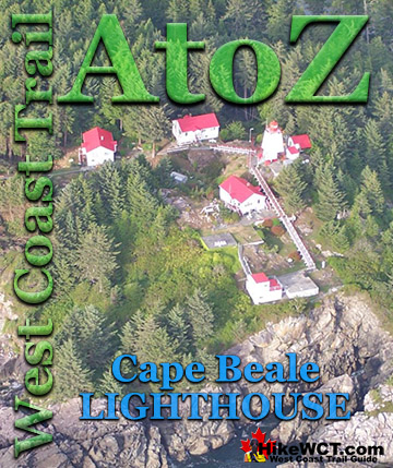
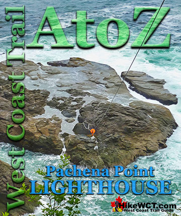
![]() The Valencia is usually regarded as the worst shipwreck disaster in the Graveyard of the Pacific and the final impetus for the creation of the West Coast Trail. The SS Valencia was an iron-hulled, 1600 ton passenger steamer built in 1882. Originally built for service between Venezuela and New York City, she later became a coastal passenger liner on the West Coast of the United States. In 1906 she was wrecked off Cape Beale, near Clo-oose, on the west coast of Vancouver Island. The captain did not take into account the strong northerly current that caused ships to overrun Juan de Fuca Strait by a considerable distance. Blinded by the weather and battered with strong winds and currents, the captain turned the Valencia toward the coast for its run into the strait. Just before midnight on the 22nd of January, she collided with the reef near Pachena Point on the southwest coast of Vancouver Island. The high number of fatalities are estimated to have been between 117 to 181. Varying sources and speculation has resulted in a fair bit of uncertainty on those figures. According to the government report at the time, the official deaths numbered 136. Only 37 men survived the shipwreck and all the woman and children perished. The Canadian government rapidly began work on what would result in the West Coast Trail. A lighthouse was was constructed and regularly spaced shelters along the newly constructed trail. The Valencia shipwreck disaster happened in 1906, the Pachena Point Lighthouse was finished in 1908, and in 1911 the West Coast Trail was completed.
The Valencia is usually regarded as the worst shipwreck disaster in the Graveyard of the Pacific and the final impetus for the creation of the West Coast Trail. The SS Valencia was an iron-hulled, 1600 ton passenger steamer built in 1882. Originally built for service between Venezuela and New York City, she later became a coastal passenger liner on the West Coast of the United States. In 1906 she was wrecked off Cape Beale, near Clo-oose, on the west coast of Vancouver Island. The captain did not take into account the strong northerly current that caused ships to overrun Juan de Fuca Strait by a considerable distance. Blinded by the weather and battered with strong winds and currents, the captain turned the Valencia toward the coast for its run into the strait. Just before midnight on the 22nd of January, she collided with the reef near Pachena Point on the southwest coast of Vancouver Island. The high number of fatalities are estimated to have been between 117 to 181. Varying sources and speculation has resulted in a fair bit of uncertainty on those figures. According to the government report at the time, the official deaths numbered 136. Only 37 men survived the shipwreck and all the woman and children perished. The Canadian government rapidly began work on what would result in the West Coast Trail. A lighthouse was was constructed and regularly spaced shelters along the newly constructed trail. The Valencia shipwreck disaster happened in 1906, the Pachena Point Lighthouse was finished in 1908, and in 1911 the West Coast Trail was completed.

Valencia shipwreck continued here...
![]() Becherdass-Ambiadass at 8k
Becherdass-Ambiadass at 8k ![]() Michigan at 12k
Michigan at 12k ![]() Uzbekistan at 13.8k
Uzbekistan at 13.8k ![]() Varsity at 17.6k
Varsity at 17.6k ![]() Valencia at 18.3k
Valencia at 18.3k
More West Coast Trail Campsites
![]() The campsite at Michigan Creek is the first or last campsite you will encounter on the West Coast Trail. First if you begin your hike at the Pachena trailhead(hiking south) and last if you begin in Port Renfrew(hiking north). The 12.1 kilometres(7.5 miles) between the Pachena trailhead and Michigan Creek is fairly easy and flat. Compared to the rest of the West Coast Trail, this section is wonderfully relaxing. At a brisk pace, you should be able to hike this section in a little over 3 hours. At a more relaxed pace, and stopping at the Pachena Lighthouse, you will take 4 or 5 hours from the trailhead. Certainly the highlight of Michigan Creek is the extraordinary remnant of the Michigan shipwreck trapped on the rocky shelf revealed by low tide. The huge boiler of the Michigan is so large that it sits ominously in a depression on the rocky shelf near where it drops off to deeper ocean. From the sandy shoreline, this rusty hulk sits about 70 metres away as large waves constantly pound it. You can easily walk out to it when the tide is low and get a close look at just a couple metres away. Getting close enough to touch it will require a short and cold plunge into the ocean with swirling water all around.
The campsite at Michigan Creek is the first or last campsite you will encounter on the West Coast Trail. First if you begin your hike at the Pachena trailhead(hiking south) and last if you begin in Port Renfrew(hiking north). The 12.1 kilometres(7.5 miles) between the Pachena trailhead and Michigan Creek is fairly easy and flat. Compared to the rest of the West Coast Trail, this section is wonderfully relaxing. At a brisk pace, you should be able to hike this section in a little over 3 hours. At a more relaxed pace, and stopping at the Pachena Lighthouse, you will take 4 or 5 hours from the trailhead. Certainly the highlight of Michigan Creek is the extraordinary remnant of the Michigan shipwreck trapped on the rocky shelf revealed by low tide. The huge boiler of the Michigan is so large that it sits ominously in a depression on the rocky shelf near where it drops off to deeper ocean. From the sandy shoreline, this rusty hulk sits about 70 metres away as large waves constantly pound it. You can easily walk out to it when the tide is low and get a close look at just a couple metres away. Getting close enough to touch it will require a short and cold plunge into the ocean with swirling water all around.


Michigan Creek campsite continued here...
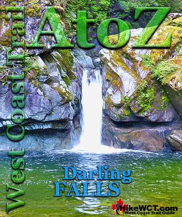
Darling River Campsite at 14km
![]() Just 2 kilometres past the popular and chaotic Michigan Creek campsite you will come to the Darling River crossing. Depending on the rainfall of previous days, you may walk through the river just a couple centimetres deep or thigh deep. When it is deep and fast moving may find it difficult to get across without slipping or getting knocked over by the current. Without significant rain, you will barely get your shoes wet crossing. After you cross, you will have arrived at the Darling River campsite. Mostly nestled along the treeline, the Darling River campsite is relatively quiet compared to Michigan Creek. The significant draw to Darling River is not the campsite, but rather the idyllic waterfalls that can be found just a few hundred metres up the river. Swimming at Darling Falls is always chilly, but the serenity of this little hideaway makes you forget the water temperature and drink in the emerald green water and rainforest surrounding you.
Just 2 kilometres past the popular and chaotic Michigan Creek campsite you will come to the Darling River crossing. Depending on the rainfall of previous days, you may walk through the river just a couple centimetres deep or thigh deep. When it is deep and fast moving may find it difficult to get across without slipping or getting knocked over by the current. Without significant rain, you will barely get your shoes wet crossing. After you cross, you will have arrived at the Darling River campsite. Mostly nestled along the treeline, the Darling River campsite is relatively quiet compared to Michigan Creek. The significant draw to Darling River is not the campsite, but rather the idyllic waterfalls that can be found just a few hundred metres up the river. Swimming at Darling Falls is always chilly, but the serenity of this little hideaway makes you forget the water temperature and drink in the emerald green water and rainforest surrounding you.


Darling River campsite continued here...
Tsocowis Creek Campsite at 16.5km
![]() The Tsocowis Creek campsite at 16.5k has a decent beach with an excellent water source. There is plenty of room for tents along the beach amongst the driftwood logs. You have the same amenities here as other West Coast Trail campsites such as deluxe outhouses and animal proof food storage boxes. Tsocowis is home to one of the West Coast Trail guard cabin's. In 1940 the survivors of the Varsity shipwreck survived by crawling their way to the shelf below what is now called Valencia Bluffs. They now found themselves on a steep shelf that they could not climb. Out of the wreckage they managed to survive exposure and construct a ladder up the cliff and found the trail that hikers now call the West Coast Trail. The three survivors made their way to Tsocowis Creek and found the Tsocowis cabin occupied by lineman who fortunately was there. The three were later picked up from Tsocowis Beach. Today the shipwreck's huge metal winch rusts in a crevice at the foot of Valencia Bluffs. Hikers tend to pass this campsite and push on to the end of the trail(or the next campsite if heading south). Everybody it seems camp at Tsusiat Falls or Klanawa River. Both less than 9 kilometres further south. Tsocowis Creek is an entry or exit point from the beach trail and there is an alternate trail that runs through the forest north to Darling River. The beach route seems far better all around however, and much easier too as you don't get slowed by hiking on sand. Still, walking along the Pacific Ocean's Graveyard of the Pacific is always something special.
The Tsocowis Creek campsite at 16.5k has a decent beach with an excellent water source. There is plenty of room for tents along the beach amongst the driftwood logs. You have the same amenities here as other West Coast Trail campsites such as deluxe outhouses and animal proof food storage boxes. Tsocowis is home to one of the West Coast Trail guard cabin's. In 1940 the survivors of the Varsity shipwreck survived by crawling their way to the shelf below what is now called Valencia Bluffs. They now found themselves on a steep shelf that they could not climb. Out of the wreckage they managed to survive exposure and construct a ladder up the cliff and found the trail that hikers now call the West Coast Trail. The three survivors made their way to Tsocowis Creek and found the Tsocowis cabin occupied by lineman who fortunately was there. The three were later picked up from Tsocowis Beach. Today the shipwreck's huge metal winch rusts in a crevice at the foot of Valencia Bluffs. Hikers tend to pass this campsite and push on to the end of the trail(or the next campsite if heading south). Everybody it seems camp at Tsusiat Falls or Klanawa River. Both less than 9 kilometres further south. Tsocowis Creek is an entry or exit point from the beach trail and there is an alternate trail that runs through the forest north to Darling River. The beach route seems far better all around however, and much easier too as you don't get slowed by hiking on sand. Still, walking along the Pacific Ocean's Graveyard of the Pacific is always something special.


Tsocowis Creek campsite continued here...
Best West Coast Trail Sights & Highlights

West Coast Trail Campsites
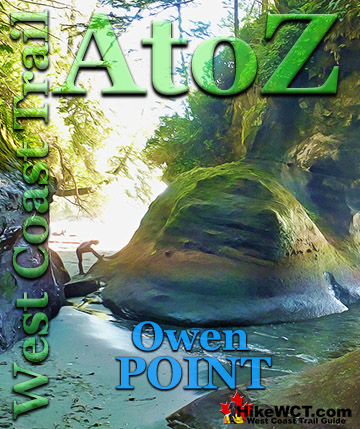
West Coast Trail A to Z
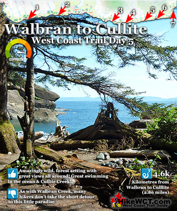
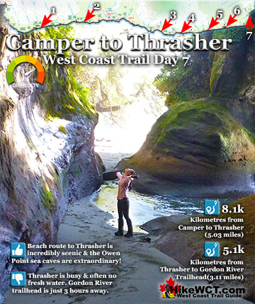
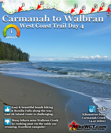
The West Coast Trail by Day

Explore BC Hiking Destinations!

The West Coast Trail
Victoria Hiking Trails

Clayoquot Hiking Trails
Whistler Hiking Trails

Squamish Hiking Trails

Vancouver Hiking Trails