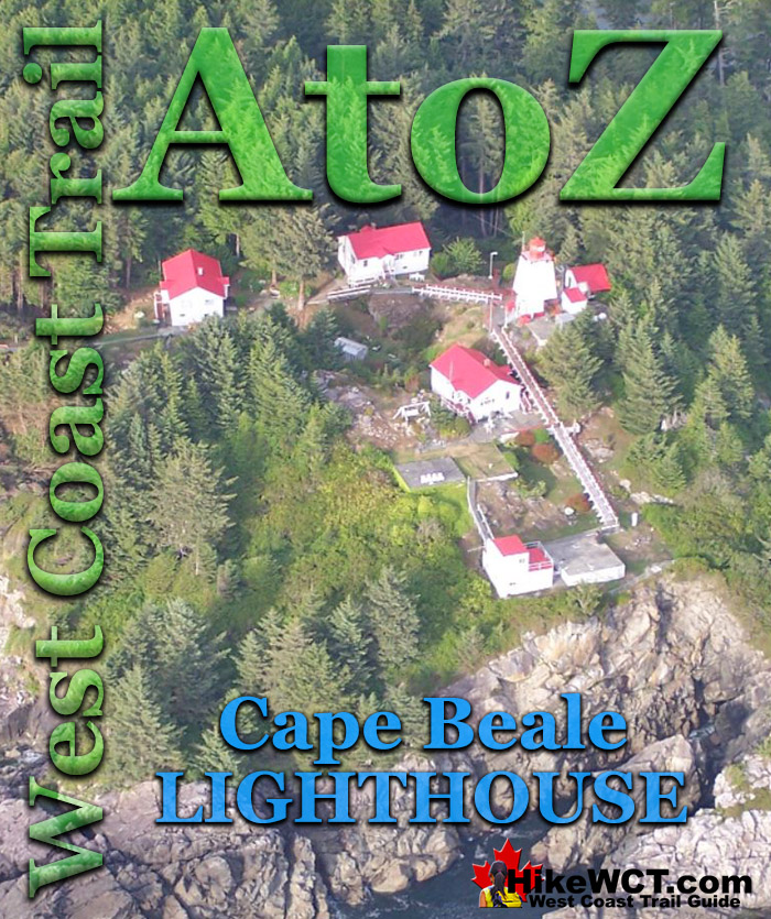
![]() The Cape Beale Lighthouse was built in 1873 and lit up the southern tip of the entrance to Barkley Sound. Barkley Sound is the huge gap in Vancouver Island filled with islands, with Ucluelet at the north end of the gap and Bamfield and Cape Beale at the south end. The West Coast Trail's Pachena Bay trailhead begins just south of Bamfield and 6 kilometres east of Cape Beale.
The Cape Beale Lighthouse was built in 1873 and lit up the southern tip of the entrance to Barkley Sound. Barkley Sound is the huge gap in Vancouver Island filled with islands, with Ucluelet at the north end of the gap and Bamfield and Cape Beale at the south end. The West Coast Trail's Pachena Bay trailhead begins just south of Bamfield and 6 kilometres east of Cape Beale.
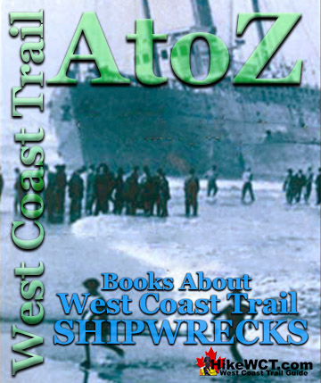
West Coast Trail Shipwrecks
![]() Alaskan at 4k
Alaskan at 4k ![]() Soquel at 5k
Soquel at 5k ![]() Sarah at 7k
Sarah at 7k ![]() Becherdass-Ambiadass at 8k
Becherdass-Ambiadass at 8k ![]() Michigan at 12k
Michigan at 12k ![]() Uzbekistan at 13.8k
Uzbekistan at 13.8k ![]() Varsity at 17.6k
Varsity at 17.6k ![]() Valencia at 18.3k
Valencia at 18.3k ![]() Janet Cowan at 19k
Janet Cowan at 19k ![]() Robert Lewers at 20k
Robert Lewers at 20k ![]() Woodside at 20.2k
Woodside at 20.2k ![]() Uncle John at 26.2k
Uncle John at 26.2k ![]() Vesta at 29k
Vesta at 29k ![]() Raita at 33k
Raita at 33k ![]() Skagit at 34.2k
Skagit at 34.2k ![]() Santa Rita at 37k
Santa Rita at 37k ![]() Dare at 39k
Dare at 39k ![]() Lizzie Marshall at 47k
Lizzie Marshall at 47k ![]() Puritan at 48.5k
Puritan at 48.5k ![]() Wempe Brothers at 49.4k
Wempe Brothers at 49.4k ![]() Duchess of Argyle at 58k
Duchess of Argyle at 58k ![]() John Marshall at 62.3k
John Marshall at 62.3k ![]() William Tell at 64.2
William Tell at 64.2 ![]() Revere at 69k
Revere at 69k ![]() Cyrus at 75k
Cyrus at 75k
West Coast Trail Campsites
![]() Pachena Bay Campground
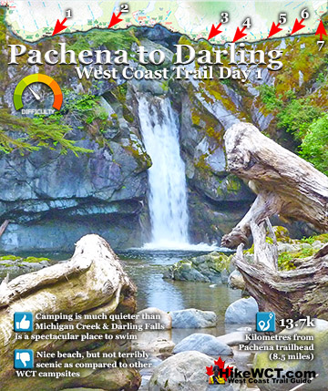
Pachena Bay Campground ![]() Michigan Creek at 12k
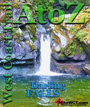
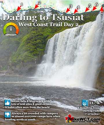
Michigan Creek at 12k ![]() Darling River at 14k
Darling River at 14k ![]() Orange Juice Creek at 15k
Orange Juice Creek at 15k ![]() Tsocowis Creek at 16.5k
Tsocowis Creek at 16.5k ![]() Klanawa River at 23k
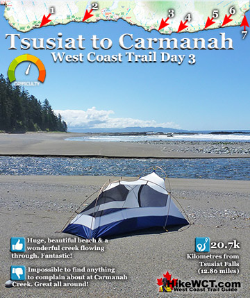
Klanawa River at 23k ![]() Tsusiat Falls at 25k
Tsusiat Falls at 25k ![]() Cribs Creek at 42k
Cribs Creek at 42k ![]() Carmanah Creek at 46k
Carmanah Creek at 46k ![]() Bonilla Creek at 48k
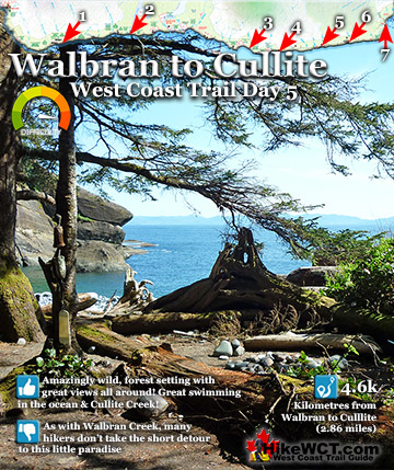
Bonilla Creek at 48k ![]() Walbran Creek at 53k
Walbran Creek at 53k ![]() Cullite Cove at 58k
Cullite Cove at 58k ![]() Camper Bay at 62k
Camper Bay at 62k ![]() Thrasher Cove at 70k
Thrasher Cove at 70k ![]() Pacheedaht Campground
Pacheedaht Campground
The Cape Flattery Lighthouse, built sixteen years earlier, sits at the northwest tip of Washington State and marks the south end of the entrance to Juan de Fuca Strait. Cape Beale is 65 kilometres northwest of Cape Flattery and about 39 kilometres northwest of the Vancouver Island side of the entrance to Juan de Fuca Strait. It wasn’t until 1891 that this northern entrance to Juan de Fuca Strait was lit up by the Carmanah Point Lighthouse. In the 1850’s Juan de Fuca Strait rapidly become a major shipping route to and from ports in Puget Sound, Vancouver and Victoria. Cape Flattery Lighthouse provided a much needed aid to navigation to Juan de Fuca Strait, which was often hidden by fog, in the midst of stormy seas and with unfamiliar currents causing a horrific number of ships to wreck in what was becoming notoriously known as the Graveyard of the Pacific. When Cape Flattery was the only lighthouse marking the entrance to the 24.5km mouth of Juan de Fuca Strait and none on the Vancouver Island side, Cape Flattery was to be the first. The obvious question is, why there? Why not directly across the strait from Cape Flattery where the Carmanah Point Lighthouse would eventually be built? The answer comes out of the chaos in the decades prior to the construction of the Cape Beale Lighthouse in 1873.
The Cape Beale Lighthouse in 1917

From Colonies to Confederation
Just a few decades earlier the British and Americans were scrambling to lay claim to territory along the west coast of North America. The Americans were rapidly pushing north claiming what is now Washington State. In an attempt to halt their expansion northward, Fort Victoria was established by the British on the southern tip of Vancouver Island in 1844. Two years later, in 1846 the Oregon Boundary Treaty defined the border along the 49th parallel which exists today as the border between Canada and the Unites States. In 1846, what would become British Columbia was a recently established British colony and the establishment of Canada as an independent country wouldn’t happen until 1867 and British Columbia wouldn’t join the Confederation of Canada until 1871. In 1871 British Columbia largely unexplored by the newly arrived Europeans, now called Canadians and probably only consisted of 11,000. The Rocky Mountains were a serious impediment to expansion into British Columbia. As the CanadaHistoryProject.ca wonderfully describes the situation in 1871. “When British Columbia joined Confederation it was so remote from the rest of Canada that mail going east had to carry an American stamp and go through San Francisco.” A transcontinental railway across Canada, through the Rocky Mountains and to the west coast of British Columbia was being constructed to connect the newly formed country.
Vancouver Island’s First West Coast Lighthouse
Now we return to the planning stage for the new lighthouse on the west coast of Vancouver Island to mitigate the huge number of shipwrecks in and out of Juan de Fuca Strait. The western terminus to the new railroad was still undecided and one strong contender was in Port Alberni located partway up Vancouver Island at the end of Alberni Inlet that almost cuts through the width of the island. Alberni Inlet connects to Barkley Sound and the Pacific Ocean. From a shipping perspective Port Alberni would reduce shipping times dramatically as compared to sailing into the treacherous Juan de Fuca Strait, around the bottom of Vancouver Island and into a Vancouver port. Largely with this in mind the planners in 1872 chose Cape Beale as the location for the new lighthouse. If shipping lanes diverted away from Juan de Fuca Strait and into Barkley Sound, a lighthouse at the entrance would be of vital importance. A year later the lighthouse was built and operational, though the terminus would be in Port Moody near Vancouver when the railroad was finally completed in 1886.

Construction of the Cape Beale Lighthouse
The construction of the Cape Beale Lighthouse illustrates wonderfully the challenges of the west coast of Vancouver Island. In the fall of 1872 the Canadian government sent surveyors and engineers to Cape Beale on the steamer Sir James Douglas. Several attempts were made to land boats on the rocky shore of Cape Beale, however the rough seas made it impossible.

The Sir James Douglas steamed five miles into Bamfield Inlet to the nearest location where they could get boats to shore. Once on shore they now had to hike 5 miles through the rainforest to Cape Beale. The forest was an almost impenetrable tangle of fallen trees and thick undergrowth. With limited time they were forced to abandon their efforts and return to Victoria after covering only about two thirds the distance. A few months later another attempt was made in the summer when seas are calmer. This time boats were successfully landed on the shore of Cape Beale and it was decided to go ahead with construction as soon as possible.

Cape Beale Lighthouse Construction Begins
Hayward and Jenkinson was awarded the government contract and construction began in the summer of 1873. The construction crew and materials arrived in the schooner Surprise and they immediately set about overcoming the logistical difficulties of building in such a wild and inaccessible place. The ship anchored in Dodger Cove, three miles north of Cape Beale. Here they were able to offload materials, ferry them across to Cape Beale and haul them up the steep slope to the construction site. A trail was constructed down to the sheltered lagoon behind the lighthouse and through the forest to the head of Bamfield Inlet three miles away. Finally the construction site was accessible by land and construction went ahead at a frantic pace. The following summer, in June 1874 the new Cape Beale Lighthouse was completed.

Carmanah Point Lighthouse Plans
In R. Bruce Scott’s wonderful book Barkley Sound A History of the Pacific Rim National Park Area, he found a newspaper article from 18 March 1873 which outlined plans to begin construction of another lighthouse on Bonilla Point in May. Bonilla Point and Carmanah Point are right next to each other and the names were often confused. To add to the confusion, Carmanah Point was previously named Bonilla Point. Scott was unable to discover the reason why this lighthouse was not started as reported and was built 17 years later in 1890, and operational in 1891.

History of Cape Beale
Cape Beale at the southern entrance to Barkley Sound was named by Captain Charles Barkley in 1787 after John Beale, a member of the crew of Barkley’s ship, the Imperial Eagle. John Beale was killed, along with four other crewmembers by Indians near Destruction Island later that year.

Cape Beale Lighthouse in Print

 Vancouver Island’s West Coast 1762-1962 by George Nicholson is a fantastic history that gives you a window to a staggering array of events that occurred during those two eventful centuries. The amount of research that went into this book must have been colossal. Dozens and dozens of beautiful illustrations bring the people and places to life. Published in 1965 after decades of living in the area, Nicholson is able to write about events he was part of. Other events that happened before his time, he is able to describe in detail only possible by living in the area and knowing every feature of the land. His sources are from the written journals of the many explorers in the area. All the other well-known West Coast Trail shipwrecks are mentioned in one chapter titled, “Forty Wrecks, One for Every Mile”. Tsusiat Falls has a chapter devoted to it as well as the Carmanah Point Lighthouse and the Cape Flattery Lighthouse. Vancouver Island’s West Coast 1762-1962 can be found online on Amazon and many other online book stores. Vancouver Island’s West Coast 1762-1962 continued here... R. Bruce Scott's second book, Barkley Sound A History of the Pacific Rim National Park Area is yet another incredible book by Scott and the second in his trilogy of books on the history of the west coast of Vancouver Island. This amazing book published in 1972 has a chapter on Pacific Rim National Park, a few chapters on some of the first European explorers. He then has chapters covering some of the trading posts and early settlements along the islands West Coast. He has an interesting chapter on the Cape Beale Lighthouse, the Carmanah Point Lighthouse and the Pachena Point Lighthouse. Barkley Sound A History of Pacific Rim Park continued here...
More West Coast Trail Glossary A to Z
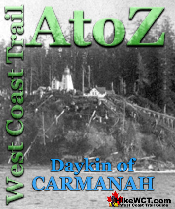
West Coast Trail A to Z

The West Coast Trail by Day

Explore BC Hiking Destinations!
The West Coast Trail
Victoria Hiking Trails
Clayoquot Hiking Trails
Whistler Hiking Trails
Squamish Hiking Trails

Vancouver Hiking Trails