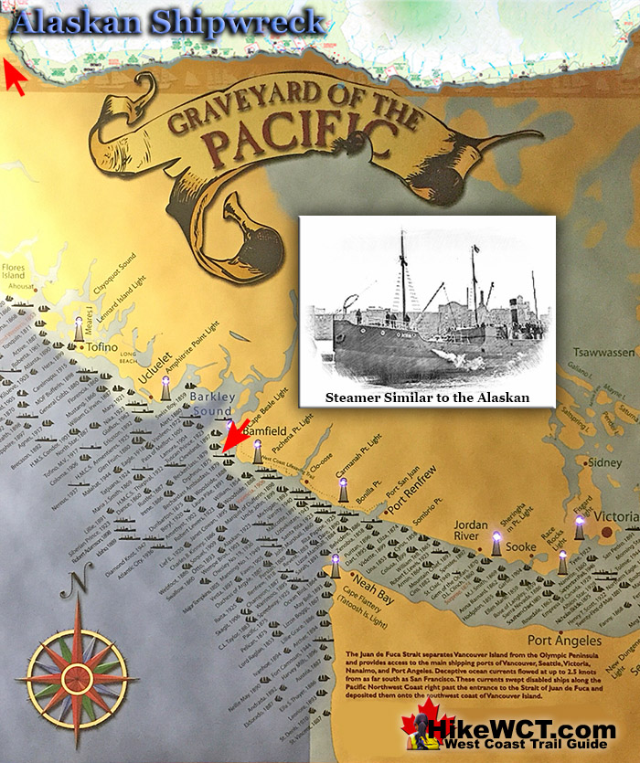
![]() The Alaskan was a small, wooden hulled steamship of 150 tons built in Oregon in 1886. She was owned by a Vancouver freight company and was on route to Kildonan in Barkley Sound with 100 tons of box shooks(metal fittings to construct wooden crates). The West Coast Trail maps given to hikers list the cargo as salt, which appears to be incorrect.
The Alaskan was a small, wooden hulled steamship of 150 tons built in Oregon in 1886. She was owned by a Vancouver freight company and was on route to Kildonan in Barkley Sound with 100 tons of box shooks(metal fittings to construct wooden crates). The West Coast Trail maps given to hikers list the cargo as salt, which appears to be incorrect.
 Alaskan Shipwreck at 4km
- Soquel Shipwreck at 5km
- Sarah Shipwreck at 7km
- Becherdass-Ambiadass Shipwreck at 8km
- Michigan Shipwreck at 12km
- Uzbekistan Shipwreck at 13.8km
- Varsity Shipwreck at 17.6km
- Valencia Shipwreck at 18.3km
- Janet Cowan Shipwreck at 19km
- Robert Lewers Shipwreck at 20km
- Woodside Shipwreck at 20.2km
- Uncle John Shipwreck at 26.2km
- Vesta Shipwreck at 29km
- Raita Shipwreck at 33km
- Skagit Shipwreck at 34.2km
- Santa Rita Shipwreck at 37km
- Dare Shipwreck at 39km
- Lizzie Marshall Shipwreck at 47km
- Puritan Shipwreck at 48.5km
- Wempe Brothers Shipwreck at 49.4km
- Duchess of Argyle Shipwreck at 58km
- John Marshall Shipwreck at 62.3km
- William Tell Shipwreck at 64.2km
- Revere Shipwreck at 69km
- Cyrus Shipwreck at 75km
The Alaskan was last seen from Pachena Point apparently unable to round Cape Beale due to high winds she evidently had turned back. Distress flares were reportedly spotted in the evening from witnesses. No one witnessed its destruction and the Alaskan and it is believed to have foundered just after 7pm on January 2nd, 1923, killing the entire crew of 11. Three bodies washed ashore with considerable debris on the beaches west of Pachena Point. You will pass the presumed location of the Alaskan shipwreck at about the 4k mark on the West Coast Trail, however there is no visible indication of the wreck for hikers to see.

Shipwrecks Near the Alaskan (KM4)
The Soquel Shipwreck Near KM5
![]() The Soquel shipwreck, which lies just past Seabird Rocks, was a much larger ship than the Alaskan at 698 tons. She was a four masted schooner built in San Francisco, California in 1902. The Soquel was sailing with ballast from Callao, Peru, heading for Port Townsend (near Seattle), when bad weather and high seas carried her far off course. The crew of 12 battled the storm as it continued to worsen, toppling two of the ship's four masts. The captains wife and daughter were killed by falling spars when the masts came crashing down on them. Throughout the night they struggled to reach a safe place to escape the storm. At some point during the the night she ran aground. The next morning, on January 22nd, 1909, the Soquel was spotted, aground on Seabird Rocks. The recently organized Bamfield lifesaving crew began a rescue operation. They battled the huge waves with their steamer, however unable to get close enough to perform a rescue. A few hours later, a second steamer arrived on the scene and together they managed to save five of the crew. Darkness prevented further rescue and the seven remaining crew had to wait out the night on the wrecked ship. The next morning calmer seas enable the rescue the remaining survivors as well as the bodies of the captain's wife and child. You will pass the presumed location of the Soquel shipwreck at about the 5km mark on the West Coast Trail, however there is no visible indication of the wreck for hikers to see.
The Soquel shipwreck, which lies just past Seabird Rocks, was a much larger ship than the Alaskan at 698 tons. She was a four masted schooner built in San Francisco, California in 1902. The Soquel was sailing with ballast from Callao, Peru, heading for Port Townsend (near Seattle), when bad weather and high seas carried her far off course. The crew of 12 battled the storm as it continued to worsen, toppling two of the ship's four masts. The captains wife and daughter were killed by falling spars when the masts came crashing down on them. Throughout the night they struggled to reach a safe place to escape the storm. At some point during the the night she ran aground. The next morning, on January 22nd, 1909, the Soquel was spotted, aground on Seabird Rocks. The recently organized Bamfield lifesaving crew began a rescue operation. They battled the huge waves with their steamer, however unable to get close enough to perform a rescue. A few hours later, a second steamer arrived on the scene and together they managed to save five of the crew. Darkness prevented further rescue and the seven remaining crew had to wait out the night on the wrecked ship. The next morning calmer seas enable the rescue the remaining survivors as well as the bodies of the captain's wife and child. You will pass the presumed location of the Soquel shipwreck at about the 5km mark on the West Coast Trail, however there is no visible indication of the wreck for hikers to see.
The Soquel shipwreck continued here...
The Sarah Shipwreck Near KM7
![]() The captain of the Sarah sighted the recently built Carmanah Point Lighthouse and mistook it for the Cape Flattery Lighthouse. The Sarah struggled against the south-east wind and the ship was pushed westward. Later the crew was able to regain their eastward coarse, toward what they though was Juan de Fuca Strait. The ocean current had moved the ship considerably far north and on the evening of the 8th November, 1891, the crew was surprised to suddenly hear distant breakers. They immediately dropped anchor, then shortly after another one. But it was too late, the Sarah ran aground on the shore of what is now KM7 of the West Coast Trail. One lifeboat was freed with some of the crew, however the captain, the rest of his crew and his wife and baby remained because the second lifeboat could not be freed. Throughout the following day and night they struggled to free the boat to make their escape to safety. Two of the crew drowned in attempting to reach the shore in a makeshift raft. Finally they managed to free another lifeboat and the survivors managed to get ashore. They were rescued by one of the many indigenous tribes residing on Vancouver Island. It seems safe to assume that it was the Huu-ay-aht First Nations which resided there, as they do now, at Pachena Bay. The Huu-ay-aht brought the shipwreck survivors to a trader's post where they found passage to Victoria on a local schooner. 16 of the crew of 18 and the captain's wife and baby survived the Sarah shipwreck.
The captain of the Sarah sighted the recently built Carmanah Point Lighthouse and mistook it for the Cape Flattery Lighthouse. The Sarah struggled against the south-east wind and the ship was pushed westward. Later the crew was able to regain their eastward coarse, toward what they though was Juan de Fuca Strait. The ocean current had moved the ship considerably far north and on the evening of the 8th November, 1891, the crew was surprised to suddenly hear distant breakers. They immediately dropped anchor, then shortly after another one. But it was too late, the Sarah ran aground on the shore of what is now KM7 of the West Coast Trail. One lifeboat was freed with some of the crew, however the captain, the rest of his crew and his wife and baby remained because the second lifeboat could not be freed. Throughout the following day and night they struggled to free the boat to make their escape to safety. Two of the crew drowned in attempting to reach the shore in a makeshift raft. Finally they managed to free another lifeboat and the survivors managed to get ashore. They were rescued by one of the many indigenous tribes residing on Vancouver Island. It seems safe to assume that it was the Huu-ay-aht First Nations which resided there, as they do now, at Pachena Bay. The Huu-ay-aht brought the shipwreck survivors to a trader's post where they found passage to Victoria on a local schooner. 16 of the crew of 18 and the captain's wife and baby survived the Sarah shipwreck.
The Sarah shipwreck continued here...
The Becherdass-Ambiadass Shipwreck Near KM8
![]() Built in 1864 the 1376 ton, 3 masted ship, Becherdass-Ambiadass was wrecked on the rocky shore only a half mile from Pachena Point. This British ship was returning from Shanghai to Moodyville (now North Vancouver) when Cape Beale was sighted. As she neared Vancouver Island early morning fog blinded her and under full sail collided with the abruptly rocky shore near the 8k mark of the West Coast Trail. Amazingly no one was seriously hurt, but the ship was wrecked. The crew used the lifeboats to save themselves. The next day a local boat carried both the crew and their belongings to Victoria. In the following weeks the ship disintegrated on the rocks. There are no remnants of wreckage from the Becherdass-Ambiadass shipwreck to see. The wreck sits under the waves not far from where the Black River meets the ocean near KM8 along the West Coast Trail.
Built in 1864 the 1376 ton, 3 masted ship, Becherdass-Ambiadass was wrecked on the rocky shore only a half mile from Pachena Point. This British ship was returning from Shanghai to Moodyville (now North Vancouver) when Cape Beale was sighted. As she neared Vancouver Island early morning fog blinded her and under full sail collided with the abruptly rocky shore near the 8k mark of the West Coast Trail. Amazingly no one was seriously hurt, but the ship was wrecked. The crew used the lifeboats to save themselves. The next day a local boat carried both the crew and their belongings to Victoria. In the following weeks the ship disintegrated on the rocks. There are no remnants of wreckage from the Becherdass-Ambiadass shipwreck to see. The wreck sits under the waves not far from where the Black River meets the ocean near KM8 along the West Coast Trail.
The Becherdass-Ambiadass shipwreck continued here...
West Coast Trail A to Z
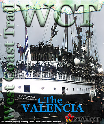
The Valencia Disaster
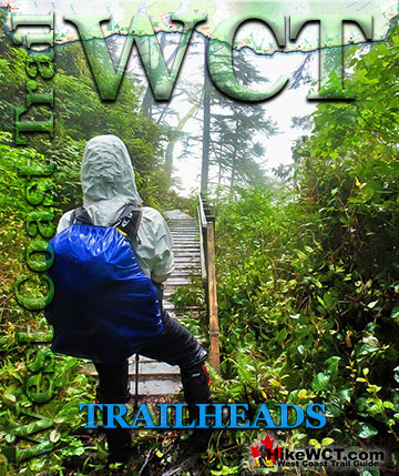
West Coast Trail Guide

Explore BC Hiking Destinations!

The West Coast Trail
Victoria Hiking Trails

Clayoquot Hiking Trails
Whistler Hiking Trails
Squamish Hiking Trails

Vancouver Hiking Trails