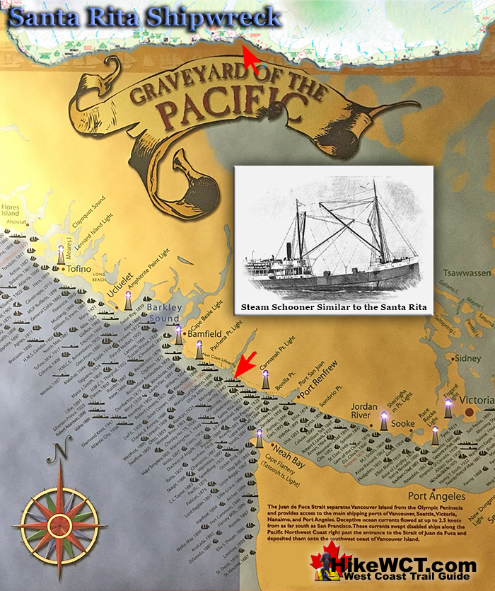
![]() Near the 37 kilometre mark on the West Coast Trail you will pass the Santa Rita, a 100 year old shipwreck hidden under the waves. The Santa Rita was a steel steam schooner, built in San Francisco in 1913. On February 15th, 1923 at 520am, this 235 foot long, 1600 ton ship collided head on with the the small island reef just a few hundred metres from the beach.
Near the 37 kilometre mark on the West Coast Trail you will pass the Santa Rita, a 100 year old shipwreck hidden under the waves. The Santa Rita was a steel steam schooner, built in San Francisco in 1913. On February 15th, 1923 at 520am, this 235 foot long, 1600 ton ship collided head on with the the small island reef just a few hundred metres from the beach.
 Alaskan Shipwreck at 4km
- Soquel Shipwreck at 5km
- Sarah Shipwreck at 7km
- Becherdass-Ambiadass Shipwreck at 8km
- Michigan Shipwreck at 12km
- Uzbekistan Shipwreck at 13.8km
- Varsity Shipwreck at 17.6km
- Valencia Shipwreck at 18.3km
- Janet Cowan Shipwreck at 19km
- Robert Lewers Shipwreck at 20km
- Woodside Shipwreck at 20.2km
- Uncle John Shipwreck at 26.2km
- Vesta Shipwreck at 29km
- Raita Shipwreck at 33km
- Skagit Shipwreck at 34.2km
- Santa Rita Shipwreck at 37km
- Dare Shipwreck at 39km
- Lizzie Marshall Shipwreck at 47km
- Puritan Shipwreck at 48.5km
- Wempe Brothers Shipwreck at 49.4km
- Duchess of Argyle Shipwreck at 58km
- John Marshall Shipwreck at 62.3km
- William Tell Shipwreck at 64.2km
- Revere Shipwreck at 69km
- Cyrus Shipwreck at 75km
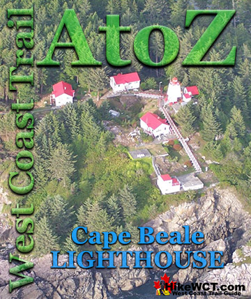
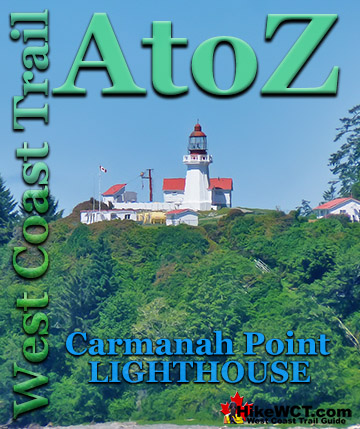
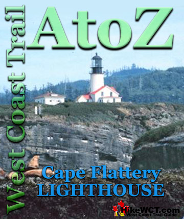
The Santa Rita was sailing in from San Pedro, California, in ballast for a port in the Puget Sound. In stormy weather and blindly navigating in poor visibility, the Carmanah Point Lighthouse was mistaken for the Cape Flattery Lighthouse on Tatoosh Island. The Carmanah Point Lighthouse is along the West Coast Trail and the Cape Flattery Lighthouse is 24.5 kilometres across Juan de Fuca Strait in the United States! The crew turned into what they thought was Juan de Fuca Strait and keeping the Cape Flattery Lighthouse on their right. Unfortunately they were about 20 kilometres north of what they thought, and were in fact keeping the Carmanah Point Lighthouse to their right and sailing directly at Vancouver Island. At 520am on February 15th, 1923 the Santa Rita collided head on into a small offshore reef just a few hundred metres from the West Coast Trail. The large ship, must have been sailing at quite a speed owing to the crew's reckoning that they were entering Juan de Fuca Strait. The sudden impact must have been horrific, loud, and completely unwarned. In the next few hours the entire crew of 30 escaped the wreck via breeches buoy. A breeches buoy is a rope based rescue system where a line runs from the ship to the shore and survivors ride in a flotation ring and leg harness.


West Coast Trail Near Santa Rita (KM37)
Nitinaht Narrows to Cribs Creek 32-41km
Highlights, gorgeous ocean views, the Cheewhat River bridge, spectacular Cheewhat Beach, amazing ladder sections, wildly beautiful, hidden Dare Beach and campsite, more stunning cliffside hiking and ocean viewpoints, the absurdly busy, worst campsite on the West Coast Trail, Cribs Creek.
West Coast Trail Highlights: Gorgeous Ocean Views
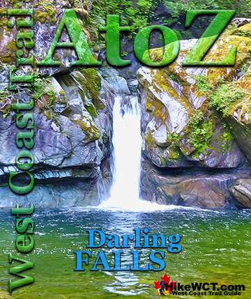
Leaving Carl's Crab Shack you hike an easy and flat section of trail through mostly flat terrain as you pass near Whyac a small First Nations community. Just past KM33 the trail runs close to cliffs overlooking the ocean and some terrific views of jagged reefs and crashing whitewater. Below is the location of another shipwreck, the Raita wrecked here in 1925 and remnants hide under the waves on the other side of those reefs.

West Coast Trail Highlights: Cheewhat Bridge
The trail continues along the coast then through the community of Clo-oose and into the forest for a short distance before arriving at the Cheewhat Bridge. The Cheewhat Bridge near KM36 is near the start of an extraordinary two kilometre section of beach. The bridge is nice and gives you great views from the middle down the river toward the ocean.

West Coast Trail Highlights: Cheewhat Beach
After the Cheewhat Bridge you almost immediately arrive at the stunning, wide open, clear sandy Cheewhat Beach that extends for two kilometres.

West Coast Trail Highlights: Dare Beach
After walking along Cheewhat Beach you have to exit the beach and hike through the forest for a short distance before you get a choice between beach or forest route. After walking the beach and sinking into the sand on every step it is nice to try the forest for a while and the forest section is nice with lots of views and not terribly challenging. Near KM39 you come to a long bridge crossing the creek that flows through Dare Beach. The view of the beach far below is fantastic. Far below you see a pool of clear green water flowing over and beside a big rock shelf emerging from the forest. The beautiful pool ends at a big jumble of deadfall logs where the creek flows through for about 15 metres before ending at a wonderful sandy beach cut through by the creek. This is Dare Beach, named after Dare Point which juts out to the right and the sight of the Dare shipwreck that happened here in 1890. The same Dare Point would claim another ship in 1923 when the 600 ton steel steamer Santa Rita wrecked here. Dare Beach an unofficial West Coast Trail campsite, so it has no campsite amenities and is not marked as a campsite on maps. There is not a lot of room to camp along the beach, but otherwise it is fantastic, especially compared to the busy and a bit ugly Cribs Creek campsite just 1.5 kilometres away.

Near KM41 you come to another end of the trail, abrupt ladder down. This one takes you down to the beach that leads to the campsite at Cribs Creek.

The Cribs Creek campsite is not the greatest and due to its location is always quite busy.

Campsites Near Santa Rita (KM37)
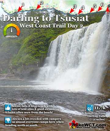
 KM25: Tsusiat Falls Campsite
One of the most popular and beautiful campsites along the West Coast Trail is Tsusiat Falls. Tsusiat Falls is one of the main highlights on the trail with its dramatically wide and beautifully picturesque appearance. You will find Tsusiat Falls near the base of a towering array of ladders extending hundreds of metres up into the trees. Tsusiat Falls pours over an abrupt and wide cliff onto the sandy beach. The force of the water has dug out quite a large pool that flows in an ever changing channel through the sand to the ocean. Tsusiat Falls campsite is wide and extends as far as you want to go down the beach. As everyone has seen pictures of it, everyone aims for it to spend the night. If you don't mind crowds then you'll love it. Tsusiat Falls campsite continued here...
 KM40: Dare Beach Campsite
Dare Beach an unofficial West Coast Trail campsite, so it has no campsite amenities and is not marked as a campsite on maps. There is not a lot of room to camp along the beach, but otherwise it is fantastic, especially compared to the busy and a bit ugly Cribs Creek campsite just 1.5 kilometres away. Near KM39 you come to a long bridge crossing the creek that flows through Dare Beach. Far below you see a pool of clear green water flowing over and beside a big rock shelf emerging from the forest. The beautiful pool ends at a big jumble of deadfall logs where the creek flows through for about 15 metres before ending at a wonderful sandy beach cut through by the creek.
 KM42: Cribs Creek Campsite
Cribs Creek at KM42 of the West Coast Trail is a nice, emerald coloured creek that flows through the messy, beach campsite. The pretty creek is about the only nice part about this campsite. The beach is not great, it smells of ageing seaweed, the sandy beach has patches of grass and bushes that give it a messy feel. Unlike many other beaches on the West Coast Trail where you have long sandy beaches carved out by the ocean in giant arcs. At Cribs Creek, you find an irregular and not very attractive beach setting. Certainly the biggest drawback to Cribs Creek is how busy it always is. Owing to its great distance to the next campsite to the north, Tsusiat Falls, everyone seems to camp here. Cribs Creek campsite continued here...
The Valencia Disaster

West Coast Trail A to Z
The West Coast Trail by Day

Explore BC Hiking Destinations!
The West Coast Trail
Victoria Hiking Trails
Clayoquot Hiking Trails
Whistler Hiking Trails
Squamish Hiking Trails

Vancouver Hiking Trails